
A lengthy but very noteworthy Extended Range Outlook issued a bit early by the WPC:
EXTENDED FORECAST DISCUSSION
NWS WEATHER PREDICTION CENTER COLLEGE PARK MD
1143 AM EDT SUN JUN 18 2017
VALID 12Z WED JUN 21 2017 - 12Z SUN JUN 25 2017
...THE SWELTERING HEAT WAVE ACROSS CA AND DESERT SOUTHWEST WILL
PERSIST THROUGH THURS BEFORE SHIFTING INTO PARTS OF CO/NM AND WEST
TX...
...THE NHC IS MONITORING AN AREA OF DISTURBED WEATHER IN THE
NORTHWESTERN CARIBBEAN, WHICH COULD MOVE INTO THE GULF OF MEXICO
AND COULD IMPACT AREAS ALONG THE GULF COAST WITH HEAVY RAINFALL
BUT MUCH REMAINS UNCERTAIN...
...PATTERN OVERVIEW/MODEL EVALUATION...
THE MEANS SUGGEST A RATHER STABLE UPPER-LEVEL PATTERN FOR MUCH OF
THE MEDIUM RANGE PERIOD, WITH A POSITIVE ANOMALY BASED ALONG THE
CENTRAL WEST COAST GRADUALLY SHIFTING TO SOUTH OF AK BY D+8, A NEG
ANOMALY REMAINING RELATIVELY STATIONARY NEAR THE UPPER GREAT LAKES
WITH LOWER HEIGHTS SPREADING SOUTH INTO THE MIDWEST AND A POSITIVE
ANOMALY MAINLY REMAINING EAST OF THE CANADIAN MARITIMES. HOWEVER,
SOME PARTICULAR SMALL SCALE DETAILS EARLY IN THE FORECAST PERIOD
HINDER THE OVERALL LARGE SCALE PATTERN OF THE OPERATIONAL MODELS
BY LATE WEEK INTO THE WEEKEND.
ONE CONSTANT FEATURE EARLY ON WILL BE THE EXPANSIVE HEAT RIDGE
ANCHORED OVER THE SOUTHWEST WITH A CLOSED 594DM HEIGHT CONTOUR.
RECORD HIGH TEMPS AND DANGEROUS HEAT LIKE CONDITIONS WILL LINGER
THROUGH MID WEEK OR THURS BEFORE CRASHING UPPER HEIGHTS NEAR THE
PAC NW/NRN ROCKIES SKIRT THE GREAT BASIN BEFORE REACHING THE
MIDWEST.
THE LARGEST UNCERTAINTY IN THE FORECAST PERIOD IS THE FUTURE OF AN
AREA OF DISTURBED WEATHER IN THE NWRN CARIBBEAN. STARTING ON WED,
A VARY OF SOLUTIONS RANGE FROM A FORMIDABLE VORT MAX AT 500MB AND
DECENT SURFACE LOW POSSIBLE NEAR THE TX GULF COAST TO THE FL
PANHANDLE, BASED ON ALL OPERATIONAL MODELS AND ENSEMBLE DATA. THE
LAST FEW RUNS OF THE GFS SHOW VERY GOOD CONTINUITY BUT IS TO THE
FAR RIGHT OF THE GUIDANCE (FL PANHANDLE), THE CANADIAN HAS SHIFTED
LEFT AND NOW IS LOCATED NEAR THE CENTRAL GULF COAST AND THE
ECMWF/UKMET AND EVEN NAM ARE MORE DIRECTED TOWARD THE CENTRAL TX
COASTLINE. THE MEANS GENERALLY SUPPORT EACH OPERATIONAL SOLUTION
FOR THE MOST PART. ITS THE INTERACTION TO A CLEAR SHEAR LINE OF
VORTICITY STRETCHING NE TO SW THROUGH THE GULF OF MEXICO AND ITS
POSSIBLE INTERACTION WITH THE TROPICAL DISTURBANCE IS UNKNOWN AND
MIGHT CONTINUE TO BE UNTIL ALL FACETS ARE BETTER DIAGNOSED BY THE
GUIDANCE. WPC FOR THE TIME BEING WENT JUST NORTH AND EAST OF THE
ECMWF/UKMET/EC MEAN AND CARRIED A TROUGH AXIS EXTENDING BACK TO
THE NORTH AND EAST IN CONSIDERATION TO THE OTHER SOLUTIONS,
GFS/GEFS/CANADIAN. EITHER WAY, THE THREAT FOR LOCALLY HEAVY RAIN
WILL BE POSSIBLE ANYWHERE FROM TX TO THE SOUTHEAST. THE FORECAST
BEYOND WED BECOMES EVEN MORE UNCERTAIN, AS SOME SOLUTIONS ALLOW
THE WESTERLIES TO PICK UP THE DISTURBANCE, WHILE OTHERS ALLOW THE
SEMI-AMPLIFIED UPPER TROUGH OVER THE EAST TO LIFT OUT AND LEAVE
THE SYSTEM BEHIND. BOTH SOLUTIONS REMAIN VERY MUCH POSSIBLE AND
NOT OUT OF THE REALM OF POSSIBILITIES. ALSO THIS UNCERTAINTY THEN
EVENTUALLY BEGINS TO IMPACT THE LARGE SCALE PATTERN FRI-SUN ACROSS
THE COUNTRY, NOT PROVIDING MUCH CONFIDENCE IN THE UPCOMING
FORECAST.
WPC STARTED WITH AN EXTENSIVE BLEND OF ALL GLOBAL MODEL
OPERATIONAL SOLUTIONS WITH ECMWF/GEFS MEANS THROUGH THURS/FRI,
GOOD AGREEMENT WITH THE TROUGH OVER THE EAST AND FAST UPSTREAM
FLOW ALONG, WHILE INCLUDING ALL SOLUTIONS CONCERNING THE THREAT IN
THE GULF/GULF COAST. HOWEVER BY NEXT WEEKEND, 80 PERCENT OF THE
BLEND WAS BASED ON THE ECMWF/GEFS AND NAEFS MEANS TO HOPEFULLY
REDUCE THE SPREAD AND CAPTURE THE OVERALL LARGE SCALE UPPER-LEVEL
PATTERN ACROSS THE COUNTRY.
...WEATHER HIGHLIGHTS...
CONSECUTIVE DAYS OF POTENTIALLY RECORD BREAKING HEAT IS EXPECTED
FROM CA/NV EAST INTO THE FOUR CORNERS REGION THROUGH THURS, WITH
DAYTIME TEMPERATURES POSSIBLY EXCEEDING THE 120 DEGREE MARK IN
SOME DESERT LOCATIONS ON WED. THE OVERALL WPC 5 DAY MEAN MAX TEMP
ANOMALY SHOWS WELL ABOVE AVG HIGHS ACROSS THE CORRIDOR AND
STRETCHING UP SOME INTO THE PAC NW AND BELOW AVG HIGHS FOR THE NRN
PLAINS/UPPER MIDWEST AND SOUTH/GULF COAST STATES.
TROPICAL HEAVY RAINFALL COULD BE A THREAT WED THROUGH FRI ANYWHERE
FROM TX TO SOUTHEAST, DEPENDING ON HOW EVERYTHING EVOLVES ACROSS
THE SRN TIER OF THE COUNTRY, JUST ABSOLUTELY TOO UNCERTAIN TO
PINPOINT THIS FAR OUT IN ADVANCE. ALSO ON WED THROUGH FRI,
CONVECTIVE HEAVY RAINFALL WILL BE POSSIBLE FROM THE CENTRAL PLAINS
AND MID/UPPER MS VALLEY INTO THE GREAT LAKES/OH VALLEY AND
NORTHEAST. THEN ON SAT, A DEEP MOISTURE PLUME WILL STRETCH FROM
THE GREAT LAKES INTO THE OH/TN VALLEYS AND MID TO LOWER MS VALLEY
INTO THE SOUTH FOR SCATTERED SHOWERS/STORMS WITH LOCALLY HEAVY
RAINS. THEN FINALLY BY NEXT SUN, MOST OF THE PRECIP SHOULD BE OVER
THE EAST INTO PERHAPS THE SOUTH AND UP INTO THE GREAT LAKES/UPPER
MS VALLEY.
MUSHER
June 2017: Typical Summertime WX To End Month
-
srainhoutx

- Site Admin

- Posts: 19615
- Joined: Tue Feb 02, 2010 2:32 pm
- Location: Maggie Valley, NC
- Contact:
Carla/Alicia/Jerry(In The Eye)/Michelle/Charley/Ivan/Dennis/Katrina/Rita/Wilma/Humberto/Ike/Harvey
Member: National Weather Association
Facebook.com/Weather Infinity
Twitter @WeatherInfinity
Member: National Weather Association
Facebook.com/Weather Infinity
Twitter @WeatherInfinity
-
srainhoutx
- Site Admin
- Posts: 19615
- Joined: Tue Feb 02, 2010 2:32 pm
- Location: Maggie Valley, NC
- Contact:
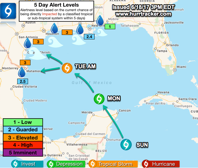
NWS National Hurricane Center Miami FL
200 PM EDT Sun Jun 18 2017
For the North Atlantic...Caribbean Sea and the Gulf of Mexico:
Showers and thunderstorms associated with a tropical wave about 800
miles east-southeast of the southern Windward Islands have become a
little better organized since yesterday. Some additional
development of this system is possible during the next couple of
days before environmental conditions become less favorable for
tropical cyclone formation. This system is forecast to move to the
west-northwest at near 20 mph toward the Windward Islands and
northeastern South America during the next two days, and interests
in these areas should monitor its progress. Regardless of
development, locally heavy rains and gusty winds are likely to
spread over portions of the Windward Islands Monday night and
Tuesday. An Air Force Reserve Hurricane Hunter aircraft is
scheduled to investigate this system on Monday, if necessary.
* Formation chance through 48 hours...medium...60 percent.
* Formation chance through 5 days...medium...60 percent.
Surface observations and satellite data indicate that a broad low
pressure area is centered near the east coast of the Yucatan
Peninsula. This system is producing a large area of showers and
thunderstorms along with winds to gale force several hundred miles
to the east and northeast of the center. However, the low lacks a
well-defined center of circulation, and the Hurricane Hunter mission
scheduled for this afternoon has been canceled. Gradual development
is expected while the low moves slowly north-northwestward across
the Yucatan Peninsula through tonight, and then over the southern or
central Gulf of Mexico on Monday and Tuesday, where a tropical or
subtropical cyclone is likely to form. Regardless of development,
heavy rains are expected over portions of Central America, the
Yucatan Peninsula, Jamaica, the Cayman Islands, and western Cuba
during the next several days. An Air Force Reserve Hurricane Hunter
aircraft is scheduled to investigate this system on Monday, if
necessary. For more information on this system, please see the
High Seas Forecast issued by the Tropical Analysis and Forecast
Branch.
* Formation chance through 48 hours...high...70 percent.
* Formation chance through 5 days...high...90 percent.
Carla/Alicia/Jerry(In The Eye)/Michelle/Charley/Ivan/Dennis/Katrina/Rita/Wilma/Humberto/Ike/Harvey
Member: National Weather Association
Facebook.com/Weather Infinity
Twitter @WeatherInfinity
Member: National Weather Association
Facebook.com/Weather Infinity
Twitter @WeatherInfinity
-
srainhoutx
- Site Admin
- Posts: 19615
- Joined: Tue Feb 02, 2010 2:32 pm
- Location: Maggie Valley, NC
- Contact:
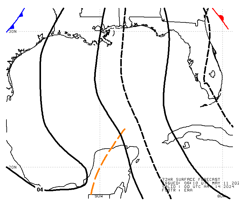
Investigating MIMIC we can see several features that are noteworthy. Clearly we can see the large/broad monsoonal gyre across the EPAC/Central America/Western/NW Caribbean. There is abundant deep tropical moisture associated with the monsoonal spin. To the East of the Bahamas, a TUTT Low is meandering West toward the Bahamas and Florida. South of the Tropical Upper Tropospheric Trough the wave axis associated with 92L is nearing the Caribbean Islands. You can see that the moisture plume in the NW Caribbean is beginning to expand into the Gulf of Mexico which had been very dry. The shear axis along the NW and Western Gulf is loosing some of it identity as it meanders West toward the Mexico Gulf Coast.

Carla/Alicia/Jerry(In The Eye)/Michelle/Charley/Ivan/Dennis/Katrina/Rita/Wilma/Humberto/Ike/Harvey
Member: National Weather Association
Facebook.com/Weather Infinity
Twitter @WeatherInfinity
Member: National Weather Association
Facebook.com/Weather Infinity
Twitter @WeatherInfinity
-
Andrew
- Site Admin
- Posts: 3440
- Joined: Wed Feb 03, 2010 9:46 pm
- Location: North-West Houston
- Contact:
Convection blow up is still well east of whatever weak LLC is present. There is a MLC located in that convection so it will be noteworthy to keep an eye on it.ticka1 wrote:wonder why they cancelled -nothing happening or LLC not forming?
Looking at models, starting to see that western solution slowly gain traction. Looks more and more likely that a Texas/Mexico landfall will be possible. With that said, this system could be quite sheared during landfall.
For Your Infinite Source For All Things Weather Visit Our Facebook

12z European model shows some very heavy rain across the area, as the system makes landfall along the middle Texas coast in a weakened state fwiw.

srainhoutx wrote:Investigating MIMIC we can see several features that are noteworthy. Clearly we can see the large/broad monsoonal gyre across the EPAC/Central America/Western/NW Caribbean. There is abundant deep tropical moisture associated with the monsoonal spin. To the East of the Bahamas, a TUTT Low is meandering West toward the Bahamas and Florida. South of the Tropical Upper Tropospheric Trough the wave axis associated with 92L is nearing the Caribbean Islands. You can see that the moisture plume in the NW Caribbean is beginning to expand into the Gulf of Mexico which had been very dry. The shear axis along the NW and Western Gulf is loosing some of it identity as it meanders West toward the Mexico Gulf Coast.
Good points. The gyre is building angular momentum. Not a big deal year about where convection is blowing up. NE quadrant will remain strongest.
Speaking of which, while HGX is still sitting on the sidelines, Hurricane Tracker app (and GEM) is siding with mid Texas coast solution. That NE side would bring a lot of rain from Houston to NOLA.
HurricaneTracker App
@hurrtrackerapp
While the center may head towards the lower-middle TX coast, effects will be felt far north & east. 6+ inches of rain possible even in SE LA
-
Texaspirate11

- Posts: 1278
- Joined: Tue Dec 31, 2013 12:24 am
- Contact:
HGX is NOT sitting on the sidelines - they are monitoring like everyone else.
No need to spread hysteria when the models cant even kumbaya.
They say in every disco "monitor and be prepared."
Not much else can be said until everything comes in....
Its OUR responsibility to be ready.
Trust me, when they are ready to hoist that flag, our NWS will be the best.
Their latest disco:
TROPICAL...
Tuesday and beyond forecast becomes increasingly dependent on
system now over western Carribean Sea forecast by all the models
to become better organized as it moves N or NW and emerges into
the Gulf of Mexico. NHC gives this system a 70 percent chance of
becoming a tropical cyclone over the next 48 hours and a 90
percent chance over the next 5 days. The track forecast for this
system is very complicated. An upper level trough over western
Gulf...as seen in model progs and water vapor imagery...will tend
to draw the system north perhaps toward the northern Gulf coast
and impose shear on the system. However there is some
indication...especially in latest runs...of this upper trough
becoming more cut off with steering currents then guiding the
system more toward the west on the northern flank of this cut off
low and with 500 mb ridge to the north. ECMWF...GFS...Canadian...
have all trended farther west with their tracks today perhaps due
to the handling of these features. Based on todays trends Texas
coast could see some impacts as early as late Wednesday or
Thursday. That said with complicated steering pattern and still no
well defined low center there remains much uncertainty in the
track of this system and all will need to continue to monitor. A
track to the east would mean little impact. As far as strength of
system...shear over Western Gulf and avaiable intensity guidance
would suggest most likely no stronger than a tropical storm but
will have more information on forecast intensity from the National
Hurricane Center when and if the tropical cyclone forms.
Last edited by Texaspirate11 on Sun Jun 18, 2017 4:05 pm, edited 1 time in total.
Just because you're disabled, you don't have to be a victim
Be Weather Aware & Prepared!
Barbara Jordan Winner in Media
Disability Integration Consultant
Be Weather Aware & Prepared!
Barbara Jordan Winner in Media
Disability Integration Consultant
thanks for reply andrew. flooding tropical systems anywhere along the gulf coast need to be monitored. My hope is being this early in the season we wont see any other tropcial action. I can wishcast right!
recently updated http://www.nhc.noaa.gov/marine/forecast ... .php?large
Synopsis for the Gulf of Mexico
GMZ001-190830-
Synopsis for the Gulf of Mexico
418 PM EDT Sun Jun 18 2017
.SYNOPSIS... Winds and seas will increase in the southern Gulf tonight in response to a broad low pressure area that will move into the southern Gulf early this week... possibly as a tropical cyclone. Widespread showers and thunderstorms with strong to near gale force winds will accompany the low as it moves into the Gulf. The low is expected to track in a general northwestward motion during the upcoming week.
72 hr (better graphics at link)
Synopsis for the Gulf of Mexico
GMZ001-190830-
Synopsis for the Gulf of Mexico
418 PM EDT Sun Jun 18 2017
.SYNOPSIS... Winds and seas will increase in the southern Gulf tonight in response to a broad low pressure area that will move into the southern Gulf early this week... possibly as a tropical cyclone. Widespread showers and thunderstorms with strong to near gale force winds will accompany the low as it moves into the Gulf. The low is expected to track in a general northwestward motion during the upcoming week.
72 hr (better graphics at link)
Last edited by unome on Sun Jun 18, 2017 4:37 pm, edited 1 time in total.
-
Texaspirate11
- Posts: 1278
- Joined: Tue Dec 31, 2013 12:24 am
- Contact:
FIRST ADVISORY FROM THE NHC ON 92L
5:00 P.M
POTENTIAL TROPICAL CYCLONE TWO FORECAST/ADVISORY NUMBER 1
NWS NATIONAL HURRICANE CENTER MIAMI FL AL022017
2100 UTC SUN JUN 18 2017
CHANGES IN WATCHES AND WARNINGS WITH THIS ADVISORY...
THE GOVERNMENT OF BARBADOS HAS ISSUED A TROPICAL STORM WARNING FOR
BARBADOS...ST. VINCENT...AND THE GRENADINES.
SUMMARY OF WATCHES AND WARNINGS IN EFFECT...
A TROPICAL STORM WARNING IS IN EFFECT FOR...
* BARBADOS
* ST. VINCENT AND THE GRENADINES
A TROPICAL STORM WARNING MEANS THAT TROPICAL STORM CONDITIONS ARE
EXPECTED SOMEWHERE WITHIN THE WARNING AREA WITHIN 36 HOURS.
POTENTIAL TROP CYCLONE CENTER LOCATED NEAR 7.5N 50.4W AT 18/2100Z
POSITION ACCURATE WITHIN 40 NM
PRESENT MOVEMENT TOWARD THE WEST OR 280 DEGREES AT 20 KT
ESTIMATED MINIMUM CENTRAL PRESSURE 1008 MB
MAX SUSTAINED WINDS 30 KT WITH GUSTS TO 40 KT.
WINDS AND SEAS VARY GREATLY IN EACH QUADRANT. RADII IN NAUTICAL
MILES ARE THE LARGEST RADII EXPECTED ANYWHERE IN THAT QUADRANT.
REPEAT...CENTER LOCATED NEAR 7.5N 50.4W AT 18/2100Z
AT 18/1800Z CENTER WAS LOCATED NEAR 7.3N 49.4W
FORECAST VALID 19/0600Z 8.2N 53.3W
MAX WIND 30 KT...GUSTS 40 KT.
Just because you're disabled, you don't have to be a victim
Be Weather Aware & Prepared!
Barbara Jordan Winner in Media
Disability Integration Consultant
Be Weather Aware & Prepared!
Barbara Jordan Winner in Media
Disability Integration Consultant
ticka1 wrote:thanks for reply andrew. flooding tropical systems anywhere along the gulf coast need to be monitored. My hope is being this early in the season we wont see any other tropcial action. I can wishcast right!
Indeed, this won't be a major wind event and fortunately not well organized, but caution is necessary, because the time window on effects re: rain and flooding could be in a 48-72 hour range. Models still have a complex forecast to work out re: direction, strength, timing, but folks should be aware of the possibility of a significant rain event...if the system heads towards Texas.
Too not create any confusion....
92l is the system approaching the eastern Caribbean and not related to 93l which is the system in the NW Caribbean. Probably best to put those updates in the hurricane section.
92l is the system approaching the eastern Caribbean and not related to 93l which is the system in the NW Caribbean. Probably best to put those updates in the hurricane section.
Bring on the rain and some cooler weather.
anything to break the heat BRING ON AUTUMN 95 DAYS!Cromagnum wrote:Bring on the rain and some cooler weather.
-
weatherguy425
- Pro Met

- Posts: 830
- Joined: Wed Feb 03, 2010 7:45 pm
- Location: Atlanta, Georgia
- Contact:
Well, for what it is worth [a bit less frustration at this point] here is some of the tightest clustering we have seen thus far. Still, a long way to go before any certainty is included with the forecast. To put it simply >> hard for models of any resolution and scale to resolve challenging features individually, let along when they are interacting with one another; ULL, ridges, etc.

-
srainhoutx
- Site Admin
- Posts: 19615
- Joined: Tue Feb 02, 2010 2:32 pm
- Location: Maggie Valley, NC
- Contact:
Sunday evening briefing from Jeff:
Tropical system in the NW Caribbean Sea organizing
Tropical Storm likely in the Gulf of Mexico as early as tomorrow…chance of development at 90%.
Residents from TX to FL should closely monitor this system as impacts will be widespread and in some cases significant.
Discussion:
While the tropical system over the NW Caribbean Sea has not organized enough to be declared a tropical depression, the overall structure of the system continues to gain slow organization. A mid level vorticity center has developed on the eastern flank of the broad surface low, but an examination of the low level wind field shows SE trades throughout this entire feature suggesting it does not have any low level circulation even though it may look impressive on satellite images. Deep convection around this mid level vort has weakened today and it is unlikely that this will work its way to the surface. Instead the broad sharping wave axis/low along the eastern coast of the Yucatan is likely to become the dominant feature later tonight into Monday as the system moves into the southern Gulf of Mexico on Monday.
The USAF mission this afternoon was cancelled, but the mission planned for Monday is expected to happen to see if a tropical depression is forming.
Track:
Model track guidance has come into better agreement today with the CMC shifting significantly to the west from SC LA to the middle TX coast. The GFS, which has been a strong NE Gulf solution also shifted west and now brings the system toward SE LA and slows it down and then inland over SC LA. The ECWMF and UKMET solutions remain steadfast in their western track toward S TX. It appears for the first time in days we are starting to see gradual model consensus on a track solution toward the W/NW Gulf of Mexico which has been favored. The complicated track factors evolve around the following features:
1) A splitting trough along the US Gulf coast with the west portion of this trough starting to move WSW toward S TX
2) Building sub-tropical highs from both the SW US toward TX and the SE US from the SW Atlantic Ocean
3) A trough across the Great Lakes which is producing a weakness in the height field over the central US Gulf coast from roughly SC LA to the FL panhandle
These three factors will be the ultimate determination of the final outcome for this system. With the trough along the US Gulf showing signs of fracturing today and starting to retrograde (move westward) this is allowing the sub-tropical ridging to begin to build from both the west and east helping to close the weakness over the central US Gulf coast. Latest ECWMF and 18Z NAM show the western portion of this trough becoming an upper level low over S TX which captures 93L’s circulation and draws it N then NW, then W toward the NW Gulf of Mexico. The 18Z NAM shows this very well. Just how fast all this happens and to what extent will determine the track. Feel much more confident that 93L will develop into the SC Gulf tomorrow and track NNW then NW into the NW Gulf by Wednesday. Track guidance has variations of the system nearing the LA coast as soon as 60-72 hours with most others nearing the TX coast in 72-96 hours.
While the confidence in the track is starting to increase only a slight deviation of the 3 factors above could result in a different track solution so forecast confidence remains low.
Intensity:
The upper level trough/developing upper low will likely help to continue to impart some degree of shear across the system as it moves northward. In fact the GFS may have been picking up on the mid and upper level portions of 93L shearing off toward FL while the other guidance has been latching onto the low level center moving more westward under the shear. What is interesting is that recent 12Z and 18Z runs are trying to show more intensification than before in what appears to be a fairly hostile environment across the Gulf as the surface low interacts with the upper level low. Such interactions can be favorable for a TC in the correct position of the venting flank of an upper level low, but the surface low must be in the correct position. Tropical Storms Allison (01) and Frances (98) both formed in this manner with the surface system interacting with an upper level low over S TX. Both of these systems had extensive moisture plumes on their eastern flank similar to the forecasted plume across the Gulf this week and both featured significant weather impacts well NE of their surface centers…another likely outcome with 93L. Proof of the deep moisture plume is seen in the ECMWF PWS (total column moisture) of nearly 3.25 inches over the central Gulf of Mexico by mid week…which is “off the charts”.
Impacts:
Broad sprawling nature of this system combined with long fetch deep moisture plume will result in impacts for hundreds of miles north and east of the center. Will not make any changes to the forecast and see if the track solutions can hold and stabilize for the next 12-18 hours. Would also like to get some sort of guidance from NHC although the coordinated NHC/WPC points will likely be the initial advisory track when they decide to upgrade or follow similar procedures as they did with the system east of the Windward Island
It should be noted that the latest NHC Gulf marine forecast has 12 foot swells approaching out 100nm waters by Wednesday.
Note: It is possible that NHC could begin issuing advisories Monday even before a tropical depression or storm is declared due to the new ability to issue advisories, watches/warnings, track within 48 hours of possible impacts.
Carla/Alicia/Jerry(In The Eye)/Michelle/Charley/Ivan/Dennis/Katrina/Rita/Wilma/Humberto/Ike/Harvey
Member: National Weather Association
Facebook.com/Weather Infinity
Twitter @WeatherInfinity
Member: National Weather Association
Facebook.com/Weather Infinity
Twitter @WeatherInfinity
GFS - Louisiana
GEM - upper Texas
Euro - lower Texas coast sticking to their guns

NAM as rain mentioned has a broad low lurking off the TX coast.

GEM - upper Texas
Euro - lower Texas coast sticking to their guns
NAM as rain mentioned has a broad low lurking off the TX coast.
-
srainhoutx
- Site Admin
- Posts: 19615
- Joined: Tue Feb 02, 2010 2:32 pm
- Location: Maggie Valley, NC
- Contact:
The sloppy mess in the NW Caribbean continues to slowly lift NNW toward the Southern Gulf. A broad surface low is currently just West of Cancun/ inland over the NE tip of the Yucatan Peninsula.
The 06Z GFS continues the Westward shift with sheared low center making Landfall near Vermilion Bay to the SSE of Lafayette. The 00Z Canadian suggests a sheared surface low making Landfall near or just to the West of High Island and finally the 00Z ECMWF suggests a weak surface low S of Corpus spinning an 850mb vorticity into Matagorda Bay.
Hopefully today we will have a better idea exactly where this mess is going, but the heavier rainfall likely will be on the NE quadrant of this disturbance.
Locally a couple of inches of rainfall appears the most likely solution with rainfall totals near or above 8 inches possible across portions of the Central/SE Louisiana and Mississippi Coast.
There remains considerable uncertainty in the sensible weather forecast along the Texas and Louisiana Coastal Areas. Until we see an actual closed surface low develop in the Southern/Central Gulf, the forecasting uncertainty will remain as well as the various modeling solutions.
- Attachments
-
Carla/Alicia/Jerry(In The Eye)/Michelle/Charley/Ivan/Dennis/Katrina/Rita/Wilma/Humberto/Ike/Harvey
Member: National Weather Association
Facebook.com/Weather Infinity
Twitter @WeatherInfinity
Member: National Weather Association
Facebook.com/Weather Infinity
Twitter @WeatherInfinity
-
Katdaddy

- Global Moderator

- Posts: 2502
- Joined: Thu Feb 04, 2010 8:18 am
- Location: League City, Tx
- Contact:
From this morning's HOU-GAL AFD regarding Invest 93L:
The National Hurricane Center`s most recent Tropical
Weather Outlook continues to say that gradual development of this system is expected when it moves over the southern or central Gulf of Mexico later today and Tuesday where a tropical or subtropical cyclone is likely to form (80% chance of formation through 48 hours and a 90% chance through 5 days). Models continue to show different scenarios on how this will all evolve, and this will probably persist until we get better system organization for the models to handle, hopefully some time later today if the reconnaissance flight can investigate. There could be significant changes to our forecast over the next several days.
-
srainhoutx
- Site Admin
- Posts: 19615
- Joined: Tue Feb 02, 2010 2:32 pm
- Location: Maggie Valley, NC
- Contact:
Monday morning briefing from Jeff:
Tropical storm likely in the Gulf of Mexico this week…a threat to the US Gulf coast
Discussion:
Disorganized tropical wave axis across the eastern Yucatan into the southern Gulf of Mexico this morning has shown little evidence of becoming any better defined overnight. Surface wind analysis shows more of an elongated trough axis than any sort of surface low. Deep convection has been firing across the western Caribbean waters much of the night, but this is well east of the sharp trough axis. The trough has become slightly better defined near the northern coast of the Yucatan where models have been suggesting for days a surface low will form.
Additionally, the upper trough over the NW Gulf of Mexico continues to produce strong shear across the central Gulf and the northern portions of the tropical wave axis. Deep tropical moisture is quickly advancing northward across the eastern gulf.
Track:
While it has been most frustrating watching the most reliable global weather forecasting computer models there is a slow but steady growing consensus on the track of this system. The complicated setup of steering flow across the Gulf of Mexico is the reason for the large spread in the model guidance with each model having its particular favored choice of which atmospheric circulation will ultimately drive the system toward the US Gulf coast. These factors include:
1) A trough over the northern Gulf coast which is fracturing and will form a weakness or upper level low over the western Gulf
2) Building sub-tropical high pressure ridges from both the SW US and the SW Atlantic.
3) A trough of low pressure over the Great Lakes
It is becoming more defined that the dominant steering pattern will evolve around the fracturing and development of an upper level low over the western Gulf of Mexico over the next 24-48 hours with 93L moving northward along the eastern flank of this large scale circulation. In fact there is enough evidence in the model guidance to suggest these two circulations actually interact more and more creating varied solutions. There is general agreement that the sharp trough axis will drift WNW today with a surface low likely forming somewhere within the northern portion of this axis and moving generally N to NNW along the eastern side of the developing upper trough over the western Gulf. This motion will continue on Tuesday as the system moves into the central Gulf of Mexico, but track guidance then becomes split with the GFS tracking 93L NNW toward southern Louisiana while the ECMWF turns 93L almost due west and toward the middle TX coast by Thursday. The CMC is down the middle tracking the system toward the upper TX coast by Thursday. The key to the track will be how much influence the developing upper trough over the western Gulf has over the developing surface low.
There is enough consensus this morning to suggest that the threat for a landfalling tropical storm on the Texas/Louisiana coasts sometime from late Wednesday into late Thursday is likely.
Intensity:
93L is highly disorganized and the atmospheric setup in the Gulf of Mexico does not look very favorable for intensification. Tropical cyclones can and at times do interact with upper level troughs like the one which is forecast to be in the western Gulf this week. The surface low on the eastern side of the large scale trough must find its way into the favorable venting portion of the trough or shear will have a negative effect on the surface low. What is interesting is that several of the global and now meso scale models show such a shearing environment across the central Gulf and then actually show decent upper air conditions as the system nears the coast. Both the high resolution NAM and CMC show a fairly symmetrical system in their 54-84 hours time periods while the GFS and ECMWF show a much more elongated and lopsided presentation.
Several Gulf of Mexico tropical systems have formed in this manner and the end result is almost always a flood event somewhere along and east of the track of a broad ill defined center.
Impacts:
Will raise seas on Tuesday to 3-4 feet across our 20-60nm waters with NHC forecasting 8-12 feet approaching our outer waters on Wednesday. Increasing tides will be possible as early as Wednesday, but will keep them below 2.0 feet total water for now. Addition of larger easterly swell onto the coast on Wednesday will likely start to pile up the water to some degree. It would seem that rain chances need to be raised to at least 50% late Wednesday and this may need additional adjusting upward. Don’t want to get much more specific with impacts at this point until either there is some guidance from NHC or the model track solutions firm up more. A track of the system toward Louisiana would result in a fairly dry and hot forecast for our area while a track toward the TX coast would result in a certainly more wet forecast.
Significant forecast changes may be required for the Wed-Fri period.
Persons along the TX/LA coasts should closely monitor the progress of 93L and be prepared for adverse conditions to potentially begin impacting the coast as early as midday Wednesday.
Carla/Alicia/Jerry(In The Eye)/Michelle/Charley/Ivan/Dennis/Katrina/Rita/Wilma/Humberto/Ike/Harvey
Member: National Weather Association
Facebook.com/Weather Infinity
Twitter @WeatherInfinity
Member: National Weather Association
Facebook.com/Weather Infinity
Twitter @WeatherInfinity