
I saw someone had posted about the HGX radar site. In the mean time, it's a good time to play around with the various IR scans of GOES-16 --> https://weather.msfc.nasa.gov/goes/abi/ ... and14.html
May 2017: Memorial Day/End Of May Outlook
-
brooksgarner

- Global Moderator

- Posts: 226
- Joined: Tue Jun 04, 2013 3:06 pm
- Location: Houston, TX
- Contact:
What's up, guys? Happy Sunday night. Just dropping in to see what's going on in the forum. The rain is all mesoscale driven. So tough to try to tell people that we can't predict the timing/amount/location exactly. "But, it's tomorrow's forecast! You can't predict 1 stinkin' day into the future?" "Nope. Sorry." haha
I saw someone had posted about the HGX radar site. In the mean time, it's a good time to play around with the various IR scans of GOES-16 --> https://weather.msfc.nasa.gov/goes/abi/ ... and14.html
I saw someone had posted about the HGX radar site. In the mean time, it's a good time to play around with the various IR scans of GOES-16 --> https://weather.msfc.nasa.gov/goes/abi/ ... and14.html
Broadcast Met
http://BrooksGarner.com
http://twitter.com/BrooksWeather
http://BrooksGarner.com
http://twitter.com/BrooksWeather
- '17 Harvey
- '12 Sandy (P3 Orion)
- '91 Bob
- '85 Gloria
RealEarth has a radar layer as well as GOES-16 & many more
https://realearth.ssec.wisc.edu/
ArcGIS
https://arcg.is/1Cj1Sz
https://www.arcgis.com/home/item.html?i ... 9024120c39
https://realearth.ssec.wisc.edu/
ArcGIS
https://arcg.is/1Cj1Sz
https://www.arcgis.com/home/item.html?i ... 9024120c39
Last edited by unome on Sun May 28, 2017 8:49 pm, edited 1 time in total.
-
srainhoutx

- Site Admin

- Posts: 19615
- Joined: Tue Feb 02, 2010 2:32 pm
- Location: Maggie Valley, NC
- Contact:
This cell is worth monitoring. Seeing reports of some impressive downburst winds.
BULLETIN - IMMEDIATE BROADCAST REQUESTED
Severe Thunderstorm Warning
National Weather Service Houston/Galveston TX
840 PM CDT SUN MAY 28 2017
The National Weather Service in League City has issued a
* Severe Thunderstorm Warning for...
Burleson County in southeastern Texas...
Northwestern Washington County in southeastern Texas...
Southwestern Brazos County in southeastern Texas...
* Until 930 PM CDT.
* At 840 PM CDT, a severe thunderstorm was located near Somerville,
or 13 miles southeast of Caldwell, moving east at 30 mph.
HAZARD...70 mph wind gusts.
SOURCE...Radar indicated.
IMPACT...Expect considerable tree damage. Damage is likely to
mobile homes, roofs, and outbuildings.
* Locations impacted include...
Western College Station, southwestern Bryan, Caldwell, Somerville,
Snook, Lake Somerville Dam, Lyons, Deanville, Independence and
Quarry.
Carla/Alicia/Jerry(In The Eye)/Michelle/Charley/Ivan/Dennis/Katrina/Rita/Wilma/Humberto/Ike/Harvey
Member: National Weather Association
Facebook.com/Weather Infinity
Twitter @WeatherInfinity
Member: National Weather Association
Facebook.com/Weather Infinity
Twitter @WeatherInfinity

Thanks so much for the GOES-16 links, Brooks and Unome. Really impressive! The KLCH and KGRK sites are covering about 2/3 of our WFO fairly well, we should survive.
A transplant from Houston to Lincoln, Nebraska.
-
srainhoutx
- Site Admin
- Posts: 19615
- Joined: Tue Feb 02, 2010 2:32 pm
- Location: Maggie Valley, NC
- Contact:
Flash Flood Statement
National Weather Service Houston/Galveston TX
903 PM CDT SUN MAY 28 2017
Houston TX-
903 PM CDT SUN MAY 28 2017
...THE FLASH FLOOD WARNING REMAINS IN EFFECT UNTIL 1015 PM CDT FOR
NORTHERN HOUSTON COUNTY...
At 901 PM CDT, local law enforcement reported heavy rain due to a
thunderstorm over Crockett. Many road closures have been reported
due to water over the road in Crockett including 6th street...4th
street...E Goliad...E Loop...S Loop...19 South...and 7 East. 4 to 6
inches of rain have fallen. Flash flooding is already ongoing.
Some locations that will experience flooding include...
Crockett, Grapeland, Kennard, Latexo and Weches.
Carla/Alicia/Jerry(In The Eye)/Michelle/Charley/Ivan/Dennis/Katrina/Rita/Wilma/Humberto/Ike/Harvey
Member: National Weather Association
Facebook.com/Weather Infinity
Twitter @WeatherInfinity
Member: National Weather Association
Facebook.com/Weather Infinity
Twitter @WeatherInfinity
-
srainhoutx
- Site Admin
- Posts: 19615
- Joined: Tue Feb 02, 2010 2:32 pm
- Location: Maggie Valley, NC
- Contact:
Alright gang, I am out for the evening. Thanks to all of you that are faithful to keeping our folks updated... 
BULLETIN - IMMEDIATE BROADCAST REQUESTED
Severe Thunderstorm Warning
National Weather Service Houston/Galveston TX
909 PM CDT SUN MAY 28 2017
The National Weather Service in League City has issued a
* Severe Thunderstorm Warning for...
Southwestern Trinity County in southeastern Texas...
Eastern Grimes County in southeastern Texas...
Northwestern Montgomery County in southeastern Texas...
Southwestern Houston County in southeastern Texas...
Eastern Madison County in southeastern Texas...
Walker County in southeastern Texas...
* Until 1000 PM CDT.
* At 908 PM CDT, severe thunderstorms were located along a line
extending from 9 miles southwest of Austonio to near Navasota,
moving east at 30 mph.
HAZARD...60 mph wind gusts and penny size hail.
SOURCE...Radar indicated.
IMPACT...Expect damage to roofs, siding, and trees.
* Locations impacted include...
Huntsville, Willis, Trinity, New Waverly, Lovelady, Montgomery,
Riverside, Anderson, Huntsville State Park, Crabbs Prairie, Dacus,
Roans Prairie and Richards.
Carla/Alicia/Jerry(In The Eye)/Michelle/Charley/Ivan/Dennis/Katrina/Rita/Wilma/Humberto/Ike/Harvey
Member: National Weather Association
Facebook.com/Weather Infinity
Twitter @WeatherInfinity
Member: National Weather Association
Facebook.com/Weather Infinity
Twitter @WeatherInfinity
https://twitter.com/iembot_hgx/status/8 ... 6424230912
http://www.spc.noaa.gov/products/md/2017/md0912.html
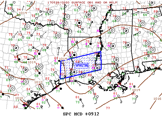
Mesoscale Discussion 0912
NWS Storm Prediction Center Norman OK
0916 PM CDT Sun May 28 2017
Areas affected...LA...Western MS
Concerning...Severe Thunderstorm Watch 296...
Valid 290216Z - 290315Z
The severe weather threat for Severe Thunderstorm Watch 296
continues.
SUMMARY...Severe threat will shift south across WW296 over the next
few hours.
DISCUSSION...Slowly expanding MCS has propagated across the northern
half of LA and the leading edge of this complex will soon shift east
of the MS River. This leading edge is oriented perpendicular to the
mean flow aloft which could enhance damaging wind potential as it
moves east, though instability is considerably weaker across MS than
LA. Trailing convection across central/western portions of the
watch has now been undercut by outflow and marginally severe hail
seems the primary threat with this elevated activity.
..Darrow.. 05/29/2017
...Please see http://www.spc.noaa.gov for graphic product...
ATTN...WFO...JAN...LIX...LCH...SHV...HGX...
LAT...LON 31199457 31939113 30629113 29889457 31199457
http://www.spc.noaa.gov/products/md/2017/md0912.html
Mesoscale Discussion 0912
NWS Storm Prediction Center Norman OK
0916 PM CDT Sun May 28 2017
Areas affected...LA...Western MS
Concerning...Severe Thunderstorm Watch 296...
Valid 290216Z - 290315Z
The severe weather threat for Severe Thunderstorm Watch 296
continues.
SUMMARY...Severe threat will shift south across WW296 over the next
few hours.
DISCUSSION...Slowly expanding MCS has propagated across the northern
half of LA and the leading edge of this complex will soon shift east
of the MS River. This leading edge is oriented perpendicular to the
mean flow aloft which could enhance damaging wind potential as it
moves east, though instability is considerably weaker across MS than
LA. Trailing convection across central/western portions of the
watch has now been undercut by outflow and marginally severe hail
seems the primary threat with this elevated activity.
..Darrow.. 05/29/2017
...Please see http://www.spc.noaa.gov for graphic product...
ATTN...WFO...JAN...LIX...LCH...SHV...HGX...
LAT...LON 31199457 31939113 30629113 29889457 31199457
https://twitter.com/iembot_hgx/status/8 ... 2233007104
Special Weather Statement
National Weather Service Houston/Galveston TX
956 PM CDT SUN MAY 28 2017
TXZ177>179-198>200-212-290330-
San Jacinto TX-Walker TX-Grimes TX-Waller TX-Liberty TX-Polk TX-
Montgomery TX-
956 PM CDT SUN MAY 28 2017
...SIGNIFICANT WEATHER ADVISORY FOR SOUTHEASTERN GRIMES...
MONTGOMERY...SAN JACINTO...NORTHEASTERN WALLER...NORTHWESTERN
LIBERTY...SOUTHERN POLK AND WALKER COUNTIES UNTIL 1030 PM CDT...
At 956 PM CDT, Doppler radar was tracking strong thunderstorms along
a line extending from 9 miles southeast of Bedias to 8 miles north of
Votaw. Movement was south at 30 mph.
Winds in excess of 40 mph will be possible with these storms.
Locations impacted include...
Conroe, Huntsville, Cleveland, Willis, Livingston, Pinehurst, The
Woodlands, Shepherd, Panorama Village, Shenandoah, Onalaska,
Splendora, Patton Village, Roman Forest, Magnolia, Woodbranch, Cut
And Shoot, New Waverly, Coldspring and Hardin.
PRECAUTIONARY/PREPAREDNESS ACTIONS...
Frequent cloud to ground lightning is occurring with these storms.
Lightning can strike 10 miles away from a thunderstorm. Seek a safe
shelter inside a building or vehicle.
These storms may intensify, so be certain to monitor local radio
stations and available television stations for additional information
and possible warnings from the National Weather Service.
&&
A severe thunderstorm watch remains in effect until 1100 PM CDT for
southeastern Texas.
LAT...LON 3049 9454 3049 9473 3017 9462 3020 9580
3025 9581 3023 9605 3089 9560 3086 9541
3083 9539 3084 9534 3086 9532 3084 9525
3080 9517 3085 9511 3081 9461
TIME...MOT...LOC 0256Z 015DEG 26KT 3068 9582 3056 9464
$$
Hathaway
-
Texaspirate11

- Posts: 1278
- Joined: Tue Dec 31, 2013 12:24 am
- Contact:
Looking at the pattern, I'm wondering if these storms will stay north of us
I'm in the Galveston bay area.
I'm in the Galveston bay area.
Just because you're disabled, you don't have to be a victim
Be Weather Aware & Prepared!
Barbara Jordan Winner in Media
Disability Integration Consultant
Be Weather Aware & Prepared!
Barbara Jordan Winner in Media
Disability Integration Consultant
https://twitter.com/iembot_hgx/status/8 ... 4047944706
http://www.wpc.ncep.noaa.gov/metwatch/m ... 84&yr=2017

MESOSCALE PRECIPITATION DISCUSSION 0284
NWS WEATHER PREDICTION CENTER COLLEGE PARK MD
1123 PM EDT SUN MAY 28 2017
AREAS AFFECTED...SOUTH TX
CONCERNING...HEAVY RAINFALL...FLASH FLOODING POSSIBLE
VALID 290320Z - 290920Z
SUMMARY...THUNDERSTORMS PRODUCING HEAVY RAINFALL RATES ARE
EXPECTED TO SPREAD FURTHER EAST ACROSS SOUTH TX OVER THE NEXT
SEVERAL HOURS. FLASH FLOODING IS POSSIBLE.
DESCRIPTION...KDFX RADAR SHOWS SLOW MOVING THUNDERSTORMS PRODUCING
RAINFALL RATES OF UP 2-3 INCHES/HR DRIFTING EAST FROM THE MIDDLE
RIO GRANDE VALLEY INTO SOUTH TX ALONG AND WEST OF I-35. THIS
CONVECTION IS FORECAST TO SPREAD FURTHER EAST INTO SOUTH TX THIS
EVENING...WITH THE POTENTIAL FOR HEAVY RAINFALL RATES EXPECTED TO
CONTINUE AS LOW LEVEL FLOW AMPLIFIES AHEAD OF AN APPROACHING WEAK
SLOW MOVING MID-LEVEL SHORTWAVE. SURFACE DEW POINTS ARE IN THE
MID 70S..WITH THE LATEST SPC MESOANALYSIS INDICATING PWS OF
1.7-1.9 INCHES ACROSS MUCH OF THE REGION. THE 01Z RAP SHOWS PWS
INCREASING TO AT OR ABOVE 2 INCHES AS MOISTURE POOLS ALONG AND
AHEAD OF A COLD FRONT THAT HAS DROPPED SOUTH AND IS EXPECTED TO
STALL ACROSS THE REGION. THE RAP ALSO SHOWS MUCAPES OF 3000-4000
J/KG PERSISTING INTO THE OVERNIGHT HOURS. THROUGH 10Z...THE 01Z
HRRR SHOWS ADDITIONAL RAINFALL ACCUMULATIONS OF UP TO 3-4 INCHES
WITHIN THE HIGHLIGHTED AREA.
PEREIRA
ATTN...WFO...BRO...CRP...EWX...HGX...
ATTN...RFC...WGRFC...
LAT...LON 28999782 28829652 27959724 27259752 26919798
26819848 26769924 27489962 28200021 28749896
http://www.wpc.ncep.noaa.gov/metwatch/m ... 84&yr=2017
MESOSCALE PRECIPITATION DISCUSSION 0284
NWS WEATHER PREDICTION CENTER COLLEGE PARK MD
1123 PM EDT SUN MAY 28 2017
AREAS AFFECTED...SOUTH TX
CONCERNING...HEAVY RAINFALL...FLASH FLOODING POSSIBLE
VALID 290320Z - 290920Z
SUMMARY...THUNDERSTORMS PRODUCING HEAVY RAINFALL RATES ARE
EXPECTED TO SPREAD FURTHER EAST ACROSS SOUTH TX OVER THE NEXT
SEVERAL HOURS. FLASH FLOODING IS POSSIBLE.
DESCRIPTION...KDFX RADAR SHOWS SLOW MOVING THUNDERSTORMS PRODUCING
RAINFALL RATES OF UP 2-3 INCHES/HR DRIFTING EAST FROM THE MIDDLE
RIO GRANDE VALLEY INTO SOUTH TX ALONG AND WEST OF I-35. THIS
CONVECTION IS FORECAST TO SPREAD FURTHER EAST INTO SOUTH TX THIS
EVENING...WITH THE POTENTIAL FOR HEAVY RAINFALL RATES EXPECTED TO
CONTINUE AS LOW LEVEL FLOW AMPLIFIES AHEAD OF AN APPROACHING WEAK
SLOW MOVING MID-LEVEL SHORTWAVE. SURFACE DEW POINTS ARE IN THE
MID 70S..WITH THE LATEST SPC MESOANALYSIS INDICATING PWS OF
1.7-1.9 INCHES ACROSS MUCH OF THE REGION. THE 01Z RAP SHOWS PWS
INCREASING TO AT OR ABOVE 2 INCHES AS MOISTURE POOLS ALONG AND
AHEAD OF A COLD FRONT THAT HAS DROPPED SOUTH AND IS EXPECTED TO
STALL ACROSS THE REGION. THE RAP ALSO SHOWS MUCAPES OF 3000-4000
J/KG PERSISTING INTO THE OVERNIGHT HOURS. THROUGH 10Z...THE 01Z
HRRR SHOWS ADDITIONAL RAINFALL ACCUMULATIONS OF UP TO 3-4 INCHES
WITHIN THE HIGHLIGHTED AREA.
PEREIRA
ATTN...WFO...BRO...CRP...EWX...HGX...
ATTN...RFC...WGRFC...
LAT...LON 28999782 28829652 27959724 27259752 26919798
26819848 26769924 27489962 28200021 28749896
-
Texaspirate11
- Posts: 1278
- Joined: Tue Dec 31, 2013 12:24 am
- Contact:
S. Tx.
Thanks.
Thanks.
Just because you're disabled, you don't have to be a victim
Be Weather Aware & Prepared!
Barbara Jordan Winner in Media
Disability Integration Consultant
Be Weather Aware & Prepared!
Barbara Jordan Winner in Media
Disability Integration Consultant
Special Weather Statement
National Weather Service Houston/Galveston TX
1136 PM CDT SUN MAY 28 2017
TXZ199-200-213-214-238-290515-
Chambers TX-Liberty TX-Galveston TX-Harris TX-Montgomery TX-
1136 PM CDT SUN MAY 28 2017
...SPECIAL WEATHER STATEMENT...
At 1136 PM CDT, Doppler radar was tracking strong thunderstorms along
a line extending from near Spring to 9 miles west of Winnie. Movement
was southeast at 20 mph.
Winds in excess of 30 mph will be possible with these storms.
Locations impacted include...
Pasadena, northern League City, Baytown, La Porte, Deer Park, South
Houston, Humble, Seabrook, Galena Park, Jacinto City, Liberty,
Dayton, Beach City, Kemah, Cloverleaf, Downtown Houston, Kingwood,
Second Ward, Greater Greenspoint and Spring.
PRECAUTIONARY/PREPAREDNESS ACTIONS...
Torrential rainfall is also occurring with these storms, and may lead
to localized flooding. Do not drive your vehicle through flooded
roadways.
&&
LAT...LON 2955 9439 2948 9436 2937 9455 2966 9538
2991 9553 3029 9540 3000 9444 2989 9444
2989 9436 2956 9435
TIME...MOT...LOC 0436Z 336DEG 46KT 3011 9536 2982 9453
$$
11

Without radar, I can't see a thing captain.

These mesos went Rorschach on us. Thought we going to get clobbered. Maybe 0.15 in.
The former outflow boundary moving through Harris Co. should provide some soaking. If the MSC NW of Corpus holds together it may provide action towards Galveston.
The former outflow boundary moving through Harris Co. should provide some soaking. If the MSC NW of Corpus holds together it may provide action towards Galveston.
DoctorMu wrote:These mesos went Rorschach on us. Thought we going to get clobbered. Maybe 0.15 in.
The former outflow boundary moving through Harris Co. should provide some soaking. If the MSC NW of Corpus holds together it may provide action towards Galveston.
Any Pearland action?
-
Texaspirate11
- Posts: 1278
- Joined: Tue Dec 31, 2013 12:24 am
- Contact:
Locations impacted include...
Pasadena, northern League City, Baytown, La Porte, Deer Park, South
Houston, Humble, Seabrook, Galena Park, Jacinto City, Liberty,
Dayton, Beach City, Kemah, Cloverleaf, Downtown Houston, Kingwood,
Second Ward, Greater Greenspoint and Spring.
Still waiting by the bay....
Pasadena, northern League City, Baytown, La Porte, Deer Park, South
Houston, Humble, Seabrook, Galena Park, Jacinto City, Liberty,
Dayton, Beach City, Kemah, Cloverleaf, Downtown Houston, Kingwood,
Second Ward, Greater Greenspoint and Spring.
Still waiting by the bay....
Just because you're disabled, you don't have to be a victim
Be Weather Aware & Prepared!
Barbara Jordan Winner in Media
Disability Integration Consultant
Be Weather Aware & Prepared!
Barbara Jordan Winner in Media
Disability Integration Consultant