Showers and a few thunderstorms this morning…warm this afternoon…showers and thunderstorms again Tuesday evening.
Morning surface charts show a strong surface low pressure system over the northern plains with a cold front and dry line extending SSW from this feature across TX. Dry line currently extends from west of Fort Worth to near Del Rio and is pushing eastward with thunderstorms mainly across N TX. Region of convergence is also leading to thunderstorm development from near Lufkin into western LA. As suspected yesterday the thermodynamics are not really in phase with the main dynamics of this storm system resulting in a fairly stable layer aloft over much of SE TX along with a fairly strong capping inversion. Storms have attempted to develop this morning in the corridor from Columbus to Lake Livingston, but have failed to gain much vertical depth. While shear profiles are very high over the region under a pronounced 50kt low level jet, the weak instability is resulting in meager updrafts and a general failure of those updrafts to take advantage of the wind shear.
Will need to continue to monitor those NE counties along and NE of a line from Huntsville to High Island where a storm or two may overcome the capping and rapidly become severe, but the best chances for any severe weather will be ENE/NE of our area. Main threat will be strong winds in any organized storms with the tornado threat greatly enhanced just to our NE.
Dry line moves to the coast tonight and stalls near the coast/just offshore. Humid air mass will return inland on Tuesday ahead of another strong short wave currently diving through the western US. This feature will bring a cold front across the area Tuesday afternoon and evening and strong lift along the front will likely generate showers and thunderstorms for areas south of HWY 105. Will need to watch the coastal counties for a possible severe threat late Tuesday and latest SPC outlook has areas from Galveston Bay eastward in a slight risk category.
Rest of the week after Tuesday looks dry and cool with lows into the 40’s and highs in the 60’s under moderate offshore flow.
Weekend:
Another storm system in this highly active pattern will move into NW MX this weekend and become cut off from the main flow aloft. This will result in cool NE surface winds becoming trapped under developing warm and most SW winds aloft. Disturbances will eject out of NE MX and across TX during this period and the overall position of the upper level storm over MX will force a fairly strong coastal trough. Guidance…especially the GFS…continues to point toward high rain chances and cool temperatures during this period. Do not think it will rain the entire time from Saturday-Tuesday, but as disturbances move across periods of rain and showers will be likely. Will likely level out temperatures in the lower 50’s through the entire period with continued cold air advection from the NE and thick clouds and rain.
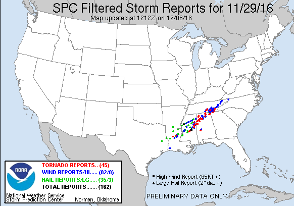
Day 1 (Monday) Severe Weather Outlook:
Carla/Alicia/Jerry(In The Eye)/Michelle/Charley/Ivan/Dennis/Katrina/Rita/Wilma/Humberto/Ike/Harvey
Member: National Weather Association
Facebook.com/Weather Infinity
Twitter @WeatherInfinity
Well this "Severe" event was very disappointing. Sprinkle of rain and many that didint get any. Have a feeling mets were way off on this one. Not even anything severe N/NE of here. Bring on winter already.
Area Forecast Discussion
National Weather Service Houston/Galveston TX
1120 AM CST Mon Nov 28 2016
.AVIATION...
A dry line is approaching SE TX and this feature could trigger
additional shra/iso tsra early this aftn. Capping over the
southern 2/3rds of the region will limit the southward extent of
the thunder and will keep KIAH southward as VCSH.A tight pressure
gradient will remain in place for much of the aftn and strong SW
winds will prevail through about 21-22z before wind speeds begin
to relax. Lighter winds expected overnight and fcst soundings show
clearing skies. SREF ensembles favor some patchy fog near the
coast and added MVFR fog at KLBX. Mstr levels begin to increase
again on Tuesday and clouds are expected to return by mid morning.
43
Area Forecast Discussion
National Weather Service Houston/Galveston TX
653 AM CST Tue Nov 29 2016
.AVIATION...
Warm front continues to lift northward and VLIFR conditions mainly
east to west through the ELA/CXO/DWH/IAH/6R3 corridor with
improving visby to the south. Area of showers and a few
thunderstorms rapidly forming between 11R-CLL-UTS-DKR. Expecting
the area of showers to expand and shift east and northeast the
next few hours. Visby should be improving across the board through
15z. As the cold front pushes into the area may get one last
squeeze to help development of showers and isolated thunderstorms
through mid afternoon for IAH/HOU. Dry NW-N flow takes over
tonight with VFR conditions following a few hours after FROPA.
45
&&
.PREV DISCUSSION... /ISSUED 450 AM CST Tue Nov 29 2016/
DISCUSSION...
Widespread dense fog noted across much of the southern half of SE
TX this morning...with the limited visibilities expected to ling-
er into the mid/late morning hours. This fog developed last night
in the wake of the yesterday`s cold front which has returned back
inland as a warm front. This boundary is expected to stall at/ar-
ound its current location (roughly along a Bellville to Cleveland
line) and could act as a focus for showers/isolated storms (given
some daytime heating). Rain chances will also buoyed with the ap-
proach/passage of a second stronger cold front this afternoon. At
this time only expecting widely scattered activity coverage given
the limited instability.
The cooler/drier weather in the wake of this front for Weds/Thurs
is expected to come to an end Friday. The return of onshore winds
and low-level moisture will be setting the stage for a wet/active
weekend. A deep closed upper low/trof (developing in the vicinity
of the California Baja) is progged to move east across nrn Mexico
Sat/Sun with a coastal surface trof setting up over the middle to
lower TX coast out ahead of it. These systems combined with poss-
ible PWs near 2" are all pointing to widespread unsettled weather
for most of the weekend with heavy rain as the main issue. Models
appear to be in slightly better agreement with these runs, but we
are still seeing the biggest differences with timing. So for now,
stay tuned. Will be adding some initial wording for this weekend
in the HWO later this morning. 41
MARINE...
Quite the variation across the UTCW with winds of 0-8 knots
nearshore and 15-19kts offshore and seas of 6-9 feet. Have kept the
marine dense fog going through 8 am with visibilities of 1 mile or
less and extended the SCA nearshore to 6 am and noon for the
offshore waters. Winds become southwest today and in general relax
somewhat ahead of the incoming cold front. Expect the cold front to
move off the coast between 6 and 8 pm near Matagorda Bay then
Galveston Bay 7-9 pm. Winds in the wake of the front gradually
increase and may need SCA/SCEC by Wednesday 3-6 am for the Gulf
waters. Northerly winds Wednesday through Thursday morning then
winds begin to veer to the NE and E. Long easterly fetch develops
late Friday as coastal troughing forms and flow ramps up bringing
another round of SCA conditions. Eventually the next front kicks
through Saturday night/early Sunday with SCA conditions again in the
wake of the frontal passage.
45
.HGX WATCHES/WARNINGS/ADVISORIES...
TX...Dense Fog Advisory until 8 AM CST this morning for the following
zones: Brazoria...Chambers...Fort Bend...Galveston...
Harris...Jackson...Liberty...Matagorda...Wharton.
GM...Dense Fog Advisory until 8 AM CST this morning for the following
zones: Galveston Bay...Matagorda Bay.
Small Craft Advisory until noon CST today for the following
zones: Waters from Freeport to the Matagorda Ship Channel
from 20 to 60 NM...Waters from High Island to Freeport from
20 to 60 NM.
Area Forecast Discussion
National Weather Service Houston/Galveston TX
1227 PM CST Tue Nov 29 2016
.AVIATION...
Slowly improving conditions in the vicinity of the stationary
boundary that is draped across the central forecast area. Drier
air filtering into the northwestern counties will work its way
southeast through the day...scattering out skies through sunset.
Winds will swing west and then northwest through the late evening
hours...completely scouring out areawide skies by midnight. Cannot
rule out a stray afternoon shower or two along this dry boundary
as it encounters warm and moist air over the near coastal terminals.
Early Wednesday VFR with a (dry) cold frontal passage timed to
come through and strengthen northerlies just before noon. 31
Beautiful sunny skies across SE TX today and tomorrow with highs in the upper 60s and lows in mid to upper 40s. A wet and cool weekend ahead with the potential for heavy rains along the Upper TX Coast.
From this morning's Hou-Gal AFD:
Main issue with the forecast looks to be the active/wet weather
progged for this weekend. As the surface high moves east of the
area, low-level moisture to return rapidly across the CWFA (via
strong onshore winds) on Friday. And combined with disturbances
(via the increasingly SW flow aloft in response to the deep up-
per low/trof out west), elevated rain chances will likely begin
Friday and persist through Sunday. These rains could be further
enhanced by the development and approach of a coastal trof from
the lower/middle TX coast. PWs associated with this system have
ranged from 1.7"-2.0" just along/off the coast and depending on
its track, could have impacts for inland portions of SE TX this
weekend. While models have been in slightly better agreement in
regard to development/strength of the main upper low/trof there
are still some differences with timing. At any rate...not going
with a lot of changes with the wet/cool forecast for this week-
end already in the grids. Stay tuned for a possible bear watch.
Katdaddy wrote:Beautiful sunny skies across SE TX today and tomorrow with highs in the upper 60s and lows in mid to upper 40s. A wet and cool weekend ahead with the potential for heavy rains along the Upper TX Coast.
From this morning's Hou-Gal AFD:
Main issue with the forecast looks to be the active/wet weather
progged for this weekend. As the surface high moves east of the
area, low-level moisture to return rapidly across the CWFA (via
strong onshore winds) on Friday. And combined with disturbances
(via the increasingly SW flow aloft in response to the deep up-
per low/trof out west), elevated rain chances will likely begin
Friday and persist through Sunday. These rains could be further
enhanced by the development and approach of a coastal trof from
the lower/middle TX coast. PWs associated with this system have
ranged from 1.7"-2.0" just along/off the coast and depending on
its track, could have impacts for inland portions of SE TX this
weekend. While models have been in slightly better agreement in
regard to development/strength of the main upper low/trof there
are still some differences with timing. At any rate...not going
with a lot of changes with the wet/cool forecast for this week-
end already in the grids. Stay tuned for a possible bear watch.
Area Forecast Discussion
National Weather Service Houston/Galveston TX
1139 AM CST Wed Nov 30 2016
.AVIATION...
VFR through the period. Gusty north winds will die out through the
afternoon as high pressure builds in from the west. A dry resident
air mass will maintain mostly clear skies with no mentionable threat
for Thursday morning fog/low clouds. Light morning winds will awake
from the east and slowly veer southeast through Thursday afternoon.
31
&&
.PREV DISCUSSION... /ISSUED 1113 AM CST Wed Nov 30 2016/
DISCUSSION...
High pressure over West Texas will build to the east this
afternoon and the tight pressure gradient along the coast will
continue to weaken. Sustained winds are less than 25 mph and the
Wind Advisory previously in effect has been cancelled. It will
remain breezy and winds are expected to subside later this
afternoon as the surface high nudges closer to SE TX. Skies have
generally cleared over all of the area and sunshine is expected
for the rest of the day. Temps are a bit tricky as full sun/heating
will be neutralized by mixing from breezy north winds and cold air
advection. Think the current temp forecast is on track and will
let it ride for now. No other changes planned at this time. 43