
Now for discussion purposes, it seems as though this Halloween will be dry ( October 2016 too), but last year....
We got 5.14 inches of rain ( it was soggy last year, chilly too) in Houston ( Bush). What does that mean? Nothing, probably. lol...
October 2016- More Cool Weather?
-
A.V.
I read somewhere that springs, falls and winters have been getting drier (with warming temps for fall and winter), while summer is becoming wetter (both for frequency and for totals). If the summer trend hits critical point, that would mean 100F days become a thing of the past.jasons wrote:Like you, I'm not trying to attribute this to a specific cause in this thread and start a climate change debate. But I am pointing out what I have observed, which it seems like a 'new normal' of hotter and drier weather in SE Texas.
-
A.V.
They are; the hottest temps in the metro area's history came during the 2000s, with the summer of 2000 (hot all around the South), and then in 2011.jasons wrote:Yet another record high...in this century. Seems like most record highs have been very recent.tireman4 wrote:Just an FYI, the record high for Halloween is 88, set in 2004 (it was bad..LOL) and the prognosticated high this year is 86. Something to monitor.
-
tireman4

- Global Moderator

- Posts: 4471
- Joined: Wed Feb 03, 2010 9:24 pm
- Location: Humble, Texas
- Contact:
HGX AFD:
00
FXUS64 KHGX 281204
AFDHGX
Area Forecast Discussion
National Weather Service Houston/Galveston TX
704 AM CDT Fri Oct 28 2016
.UPDATE...
Have expanded the Dense Fog Advisory a little further north based
on observations and webcams. Have added Columbus/Austin/Waller
counties to the advisory through 9 am.
45
&&
.PREV DISCUSSION... /ISSUED 640 AM CDT Fri Oct 28 2016/
AVIATION...
Patchy fog has impacted Angleton and Sugar Land this morning,
with visbilities bouncing between VLIFR and MVFR. Early morning
surface analysis shows the best surface moisture having pooled
along and south of the Interstate 10 corridor this morning and
expect majority of fog impacts to reside southwest of the Houston
terminals as a result. However, observational trends at Houston
IAH suggest that a brief window of MVFR fog is possible and have
included a TEMPO group through 13Z. Expect fog to dissipate
14-15Z, with VFR conditions and east to southeast winds less than
10 knots prevailing through this evening. Another round of fog is
expected for Southeast Texas terminals early Saturday morning as a
wave of moisture pushes inland off the Gulf with visibilities
dropping to MVFR to IFR and improving by mid-morning Saturday.
Huffman
PREV DISCUSSION... /ISSUED 440 AM CDT Fri Oct 28 2016/
DISCUSSION...
Short term concern is patchy dense fog mainly south of a Fulshear
to Pearland this morning. Patch shallow fog possible a little
further north but may not be dense. Webcams showing the patchy
nature of the fog in the advisory area and visibilities may be
lower than 1/4 mile at times. A few showers will also be possible
over the Gulf waters and nearing the Matagorda Bay region early
this morning.
WV imagery clearly showing the upper ridging over TX and an upper
low over the Gulf south of LA. The upper low will retrograde to
near the Lower TX coast by Saturday morning so this should keep
the moist inflows going across SETX and focus rain chances mainly
over the Gulf waters and possibly into the coastal counties.
Soundings look to have a decent warm subsidence inversion in
place so any spotty light precip should be in the form of
showers. With the upper ridge dominating the weather while
traversing TX expect temperatures to continue well above normal
through the weekend.
Halloween should be warm and humid with just a slight chance of
showers. Tuesday morning a surge of deeper moisture arrives and
rain chances will increase along with warmer mins/slightly cooler
max temps thanks to widespread cloud cover and 30-40 percent
chance of showers and thunderstorms. PW values may approach
1.8-1.9" with the moisture gradually thinning on Wednesday as
ridging settling in to the east of the area begins to tap into
drier/recirculated air edges in from the east and northeast. Good
deal of uncertainty in the forecast beyond Tuesday with the fast
westerly flow across the Pacific and for that matter the northern
U.S. for now favoring the GFS about 60/40 over the ECMWF...digging
trough over the Eastern Seaboard could lead to drier weather again
by next Fri.
45
MARINE...
Light to occasionally moderate east to southeast winds will persist
through the weekend and into the upcoming week as surface ridging
maintains its influence over the central Gulf Coast states. Winds
may approach caution criteria at times, with the long east/southeast
fetch across the Gulf allowing waves for the offshore waters to
build into the 4 to 6 feet range by the end of the weekend.
Persistent onshore flow will also lead to a gradual increase in tide
levels through next week. Increasing moisture will result in
scattered showers and thunderstorms returning to the coastal waters
early to mid next week.
Huffman
&&
.PRELIMINARY POINT TEMPS/POPS...
College Station (CLL) 87 63 87 63 87 / 10 0 10 0 10
Houston (IAH) 86 64 86 64 87 / 10 0 10 0 10
Galveston (GLS) 82 73 83 73 82 / 10 0 10 0 10
&&
.HGX WATCHES/WARNINGS/ADVISORIES...
TX...Dense Fog Advisory until 9 AM CDT this morning FOR THE FOLLOWING
ZONES: Austin...Brazoria...Colorado...Fort Bend...
Matagorda...Waller...Wharton.
GM...NONE.
&&
$$
Discussion...45
Marine...14

Projections are for longer dry spells:A.V. wrote:They are; the hottest temps in the metro area's history came during the 2000s, with the summer of 2000 (hot all around the South), and then in 2011.jasons wrote:Yet another record high...in this century. Seems like most record highs have been very recent.tireman4 wrote:Just an FYI, the record high for Halloween is 88, set in 2004 (it was bad..LOL) and the prognosticated high this year is 86. Something to monitor.
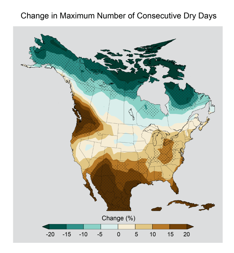
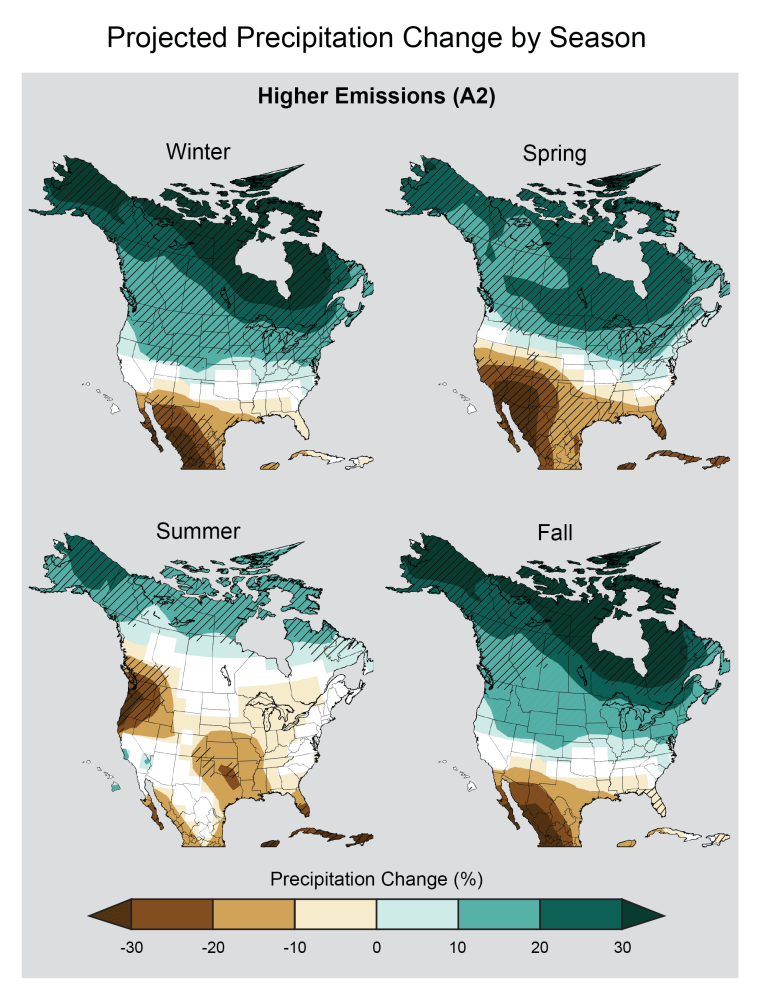
and reduction in soil moisture
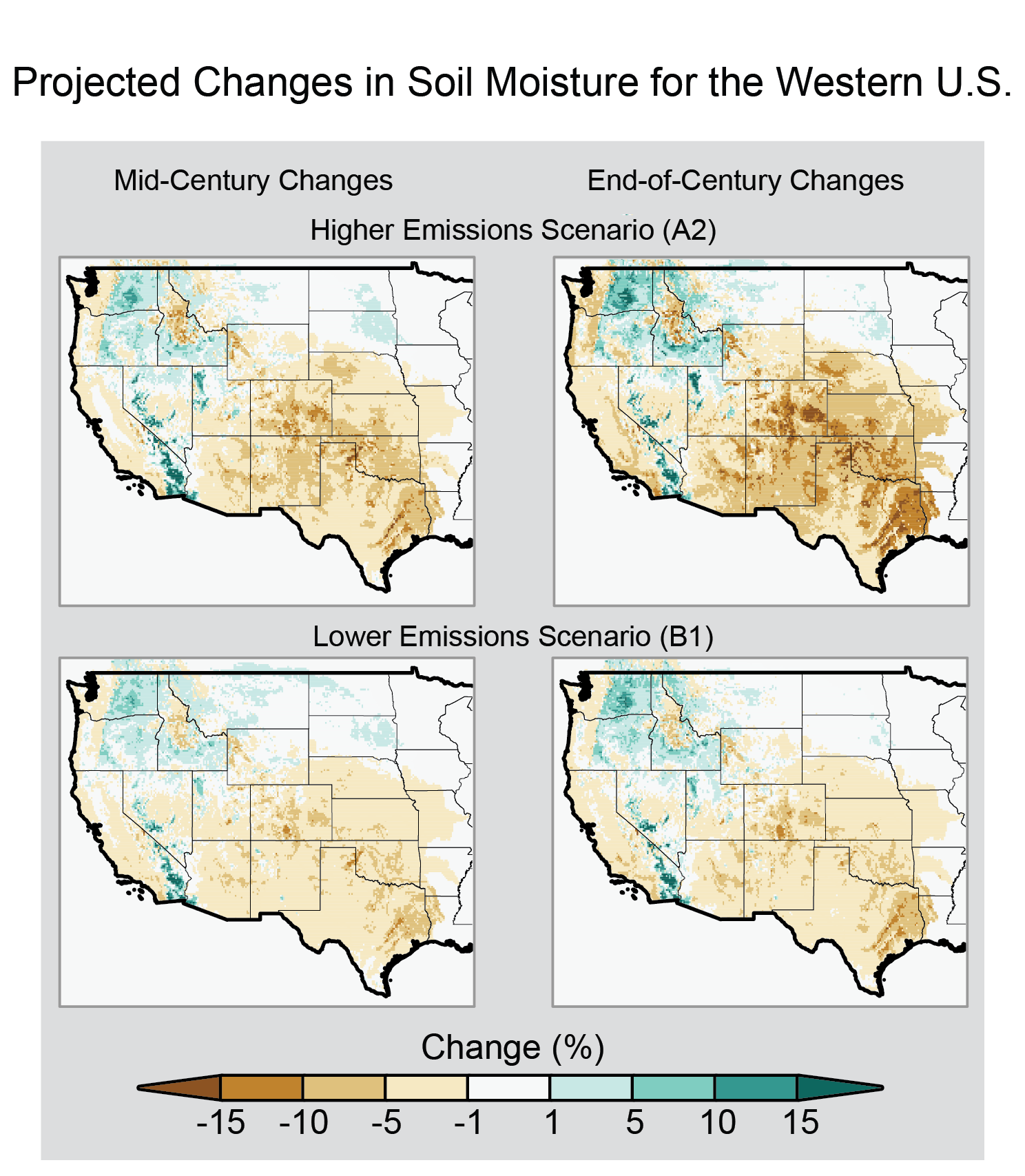
current trends
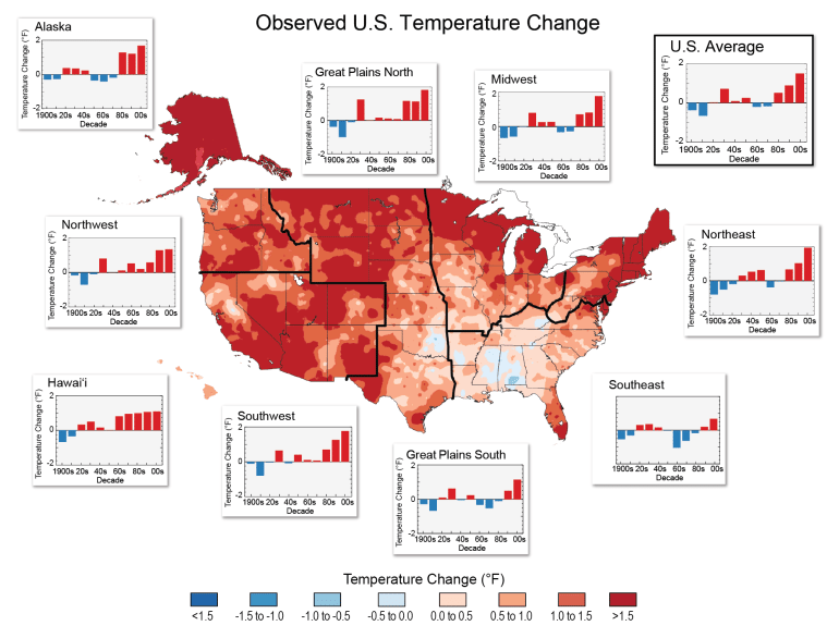
Having lived for Texas for 25 years and tracking the weather I've noticed:
1. Warmer lows in the Spring, Summer, and early Fall
2. More extremes in rainfall: feast or famine
3. Drier soil overall
4. Spring tornado season nudging earlier
-
Katdaddy

- Global Moderator
- Posts: 2502
- Joined: Thu Feb 04, 2010 8:18 am
- Location: League City, Tx
- Contact:
A Dense Fog Advisory is in effect for SE TX this Halloween morning. The first week of Nov will feel more like Summer than Fall. Well needed rain chances increase tomorrow and Wednesday followed by a front on Friday. Next weekend looks to be a little cooler and dry.
- Attachments
-
- Screen Shot 2016-10-31 at 5.17.13 AM.png (25.39 KiB) Viewed 4855 times
-
tireman4
- Global Moderator
- Posts: 4471
- Joined: Wed Feb 03, 2010 9:24 pm
- Location: Humble, Texas
- Contact:
This Halloween will be a warm one. Progged at 86 for a high..77 by the time the Trick or Treaters hit the streets. The record high is 88 set back in 2004.
161
FXUS64 KHGX 311205 CCA
AFDHGX
Area Forecast Discussion...CORRECTED
National Weather Service Houston/Galveston TX
705 AM CDT Mon Oct 31 2016
.AVIATION...
Much like the past few mornings, the main concern for the 31/12Z
TAFs centers around fog at the Southeast Texas terminals this
morning.
Split channel satellite imager shows fog continuing to expand
northward of the Interstate 10 corridor, with visibilities ranging
from VFR to VLIFR as the fog spreads northward. VFR conditions at
Houston IAH and College Station now are expected to briefly drop
to IFR at IAH and VLIFR at CLL as fog spreads into the terminals
from the south and east. Expect conditions to improve back to VFR
15-17Z, with south to southeast winds 10 knots or less prevailing
at all terminals. Another round of fog development is possible
early Tuesday morning, with greatest potential for category
restrictions at the terminals north and west of Houston (CLL, UTS,
CXO, SGR, LBX).
Huffman
&&
.PREV DISCUSSION... /ISSUED 509 AM CDT Mon Oct 31 2016/
DISCUSSION...
High pressure over E TX/LA/MS dominating the weather with light
winds and mostly clear skies early this morning. Areas of
fog/dense fog forming mainly along and south of the I-10 corridor
but will likely expand northward through 7 am...faster expansion
west of the I-45 corridor. By 9-10 am expect the fog to have mixed
out and dissipate but with some scattered cloudiness remaining.
Another warm after on tap with highs in the mid 80s inland still
far above normal but not into the records. The ridge over the area
will be weakening and shifting east which will allow the deeper
moisture pooled over the Gulf to the east of the upper shear axis
near Brownsville to nose up into the Matagorda Bay region late
this afternoon which could lead to some isolated showers there.
Moisture will be on the increase across the region Tuesday morning
and will probably see another round of fog across the area. In
addition scattered showers transitioning over to showers and
thunderstorms by mid morning first near the coast then expanding
north over the area with heating (mainly west of I-45). Rain
chances continue on Wednesday mainly driven by daytime heating and
morning speed convergence near the coast. Elevated tide levels on
tap for the first half of the week. Thursday a cold front slowly
sags south through the state and prefrontal troughing may help to
lessen the rain chances with winds backing before the fropa early
Friday morning. Tuesday and Wednesday have a chance of seeing some
brief heavy downpours with slow moving storms but then by Thursday
coverage will probably be lower and amounts lighter.
1025-1030mb high builds into lower MS valley Friday through
Sunday and drier weather should return to SETX but with more
cloud cover so probably a smaller diurnal range over the west and
larger in the east with the greater dry air and lesser cloud
cover. The extended guidance starting to point toward an
interesting weather pattern for SETX Monday-Wednesday with a
vigorous upper low bowling balling into TX with the potential for
generous rainfall over the eastern half of TX or possibly focused
closer to the coast...maybe even some severe potential but of
course it is fall and the models haven`t been verifying well
beyond 144 hours. Stay tuned.
MARINE...
Generally easterly flow continues across the coastal waters early
this morning, but have begun to see winds across the offshore waters
begin to back more towards the northeast as a weak coastal trough
has developed off the Lower/Middle Texas coast. This coastal trough
will serve as a focus for isolated showers across the western waters
today, with scattered showers and thunderstorms expected to develop
Tuesday through Thursday as deeper Gulf moisture and an upper level
disturbance approach the waters.
Marine hazards through late week will center around periods of
elevated seas and onshore winds resulting in caution flags as well
as rip current and tidal issues along beaches. Seas currently range
from 3 feet at Buoy 42035 to 5 feet at Buoy 42019 and expect seas
generally in the 2-5 ft range to persist through mid to late week as
onshore flow continues. Long period swells will continue to result
in an elevated risk for rip currents and elevated tides along the
Upper Texas coast, with tidal guidance showing levels rising into
the 3-3.3 foot range above MLLW at times of high tide later this
evening. This would result in minor overwash on Highway 87 at
Highway 124 on Bolivar Peninsula as well as minor beach flooding for
Gulf-facing beaches at times of high tide over the next few days. A
cold front looks to reach the northwest Gulf by the upcoming
weekend, allowing for decreasing waves and tides as it passes.
Huffman
&&
.PRELIMINARY POINT TEMPS/POPS...
College Station (CLL) 87 67 84 69 82 / 0 0 30 20 40
Houston (IAH) 86 68 82 70 83 / 0 0 20 20 20
Galveston (GLS) 82 74 82 74 81 / 0 0 20 20 30
&&
.HGX WATCHES/WARNINGS/ADVISORIES...
TX...Dense Fog Advisory until 10 AM CDT this morning for the
following zones: Austin...Brazoria...Brazos...Burleson...
Chambers...Colorado...Fort Bend...Galveston...Grimes...
Harris...Houston...Jackson...Liberty...Madison...
Matagorda...Montgomery...Polk...San Jacinto...Trinity...
Walker...Waller...Washington...Wharton.
GM...SMALL CRAFT SHOULD EXERCISE CAUTION until 7 AM CDT this morning
for the following zones: Waters from Freeport to the
Matagorda Ship Channel from 20 to 60 NM...Waters from High
Island to Freeport from 20 to 60 NM.
&&
$$
Discussion...45
Aviation/Marine...14
-
tireman4
- Global Moderator
- Posts: 4471
- Joined: Wed Feb 03, 2010 9:24 pm
- Location: Humble, Texas
- Contact:
HGX AFD:
000
FXUS64 KHGX 311819
AFDHGX
Area Forecast Discussion
National Weather Service Houston/Galveston TX
119 PM CDT Mon Oct 31 2016
.AVIATION...
VFR conditions will persist through the afternoon into this
evening. Water Vapor satellite loops show that moisture has been
on the rise along the coastal areas west of Houston and Galveston.
This may help to increase cloudiness over KGLS and KLBX tonight
and possible as far inland as KHOU, KIAH, and KSGR. The surface
ridge over Southeast Texas should continue in place tonight.
Outside of areas where any mid level cloudiness develops, do
expect conditions to become conducive once again for fog
development. If so, IFR to LIFR will be possible mainly between
10Z and 15Z. A model consensus has the fog development mainly from
the I-10 corridor inland -- KIAH, KCXO, KUTS, and KCLL -- with
KHOU and KSGR on the edge of possibility. Any fog and low ceilings
that do develop should lift by or shortly after 16Z on Tuesday.
40
&&
-
tireman4
- Global Moderator
- Posts: 4471
- Joined: Wed Feb 03, 2010 9:24 pm
- Location: Humble, Texas
- Contact:
To wrap up October..2016 and just how warm it has been...
This was the 9th warmest October at IAH.
By way of comparison, October 2016 was the second warmest in history...at Houston Hobby
Sixth warmest October at College Station
Second warmest October in Galveston
Onward to November...
This was the 9th warmest October at IAH.
By way of comparison, October 2016 was the second warmest in history...at Houston Hobby
Sixth warmest October at College Station
Second warmest October in Galveston
Onward to November...