
August 2016: Rain Chances Continue.

I have noticed the days are getting shorter, and it's no longer bright white light at 4pm any longer. The sun is getting that fall-like softer orange-ish glow now in the afternoon.
you can make a sunrise/sunset calendar here http://www.sunrisesunset.com/predefined.asp - I like to add the civil twilight & day length & it gives a better idea of how much daylightjasons wrote:I have noticed the days are getting shorter, and it's no longer bright white light at 4pm any longer. The sun is getting that fall-like softer orange-ish glow now in the afternoon.
here's Houston, August: http://www.sunrisesunset.com/calendar.a ... n=1&wadj=1
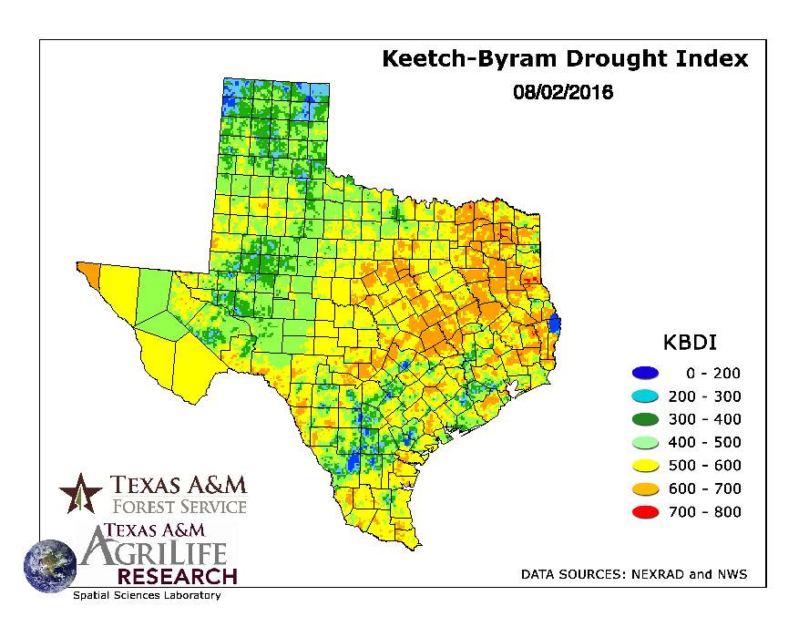
Thanks. Yeah the KBDI keeps creeping up despite the rains from last week. LOTS of orange covering the Montgomery County forests - what's left of them.
-
Katdaddy

- Global Moderator

- Posts: 2502
- Joined: Thu Feb 04, 2010 8:18 am
- Location: League City, Tx
- Contact:
Hot SE TX weather through the weekend with a 20-30% chance of afternoon thunderstorms with high temps in the upper 90s. Not sure Snoopy would approve but the dog days of August are upon us. TS Earl is approaching hurricane strength and is forecast to become an 80MPH CAT 1 by landfall in Belize. We will have nil effects across SE TX thanks to the strong ridge in place. However with that said the peak of hurricane season is upon us and this morning's Hou-Gal NWS AFD make an excellent point:
Hopefully Earl is succeeding in knocking a bit of the rust off, and reminding people that despite the long hurricane drought in the Gulf of Mexico, everyone needs to have a plan and be prepared for tropical threats.
Hopefully Earl is succeeding in knocking a bit of the rust off, and reminding people that despite the long hurricane drought in the Gulf of Mexico, everyone needs to have a plan and be prepared for tropical threats.

Damn, it's hot.
yup... I second that, hang in there, not getting cooler any time soonDoctorMu wrote:Damn, it's hot.
http://www.srh.noaa.gov/NWSwidget/index ... 0680000001
http://www.srh.noaa.gov/NWSwidget/index ... 6155814603
-
Texaspirate11

- Posts: 1278
- Joined: Tue Dec 31, 2013 12:24 am
- Contact:
unome wrote:yup... I second that, hang in there, not getting cooler any time soonDoctorMu wrote:Damn, it's hot.
http://www.srh.noaa.gov/NWSwidget/index ... 0680000001
http://www.srh.noaa.gov/NWSwidget/index ... 6155814603
It's August.
Just because you're disabled, you don't have to be a victim
Be Weather Aware & Prepared!
Barbara Jordan Winner in Media
Disability Integration Consultant
Be Weather Aware & Prepared!
Barbara Jordan Winner in Media
Disability Integration Consultant
Yeah, I remember reading the discussions last week and over the weekend, and they predicted this week to be hot & dry, with a return to a more moist pattern - at least typical 20-30% showers - starting back today. They even mentioned a few waves could gives us some more heavy rain threats. I haven't read the last few days, but it appears this has now changed for the worse. Other than a little break tomorrow, it looks like the hot & dry pattern is here for awhile as the ridge holds in place. Boo-hiss!
-
houstonia
- Posts: 138
- Joined: Sun Jun 14, 2015 6:51 pm
- Location: Houston, Texas (Southwest side; Sharpstown)
- Contact:
This looks very neat. Thanks unome!unome wrote:you can make a sunrise/sunset calendar here http://www.sunrisesunset.com/predefined.asp - I like to add the civil twilight & day length & it gives a better idea of how much daylightjasons wrote:I have noticed the days are getting shorter, and it's no longer bright white light at 4pm any longer. The sun is getting that fall-like softer orange-ish glow now in the afternoon.
here's Houston, August: http://www.sunrisesunset.com/calendar.a ... n=1&wadj=1
-
MontgomeryCoWx

- Posts: 2356
- Joined: Wed Dec 14, 2011 4:31 pm
- Location: Weimar, TX
- Contact:
jasons wrote:Yeah, I remember reading the discussions last week and over the weekend, and they predicted this week to be hot & dry, with a return to a more moist pattern - at least typical 20-30% showers - starting back today. They even mentioned a few waves could gives us some more heavy rain threats. I haven't read the last few days, but it appears this has now changed for the worse. Other than a little break tomorrow, it looks like the hot & dry pattern is here for awhile as the ridge holds in place. Boo-hiss!
Yep, I loathe Summer here. I'm ready for mid October.
Team #NeverSummer
-
A.V.
It hasn't worsened all that much (as of time of writing); rainfall still looks to continue next week, and I have my suspicions that the high pressure moves, just not as coordinated as tracked by models. It might be 'eratic;' they will trend drier just because the high pressure hasn't moved, but it can suddenly take exit left, upping rain chances.jasons wrote:Yeah, I remember reading the discussions last week and over the weekend, and they predicted this week to be hot & dry, with a return to a more moist pattern - at least typical 20-30% showers - starting back today. They even mentioned a few waves could gives us some more heavy rain threats. I haven't read the last few days, but it appears this has now changed for the worse. Other than a little break tomorrow, it looks like the hot & dry pattern is here for awhile as the ridge holds in place. Boo-hiss!
-
A.V.
Summer storms were far easier to come by in the previous decade. I don't think lengthy periods of dryness are normal at all for Coastal Texas.
-
srainhoutx

- Site Admin

- Posts: 19616
- Joined: Tue Feb 02, 2010 2:32 pm
- Location: Maggie Valley, NC
- Contact:
Will need to monitor for a potential Tropical Troublemaker organizing off the Northern Gulf mid next week. The Global models are suggesting the upper Ridge breaks down and lowering heights/pressures become established over our Region in about a week as a vigorous trough moves East across the Central United States.
Carla/Alicia/Jerry(In The Eye)/Michelle/Charley/Ivan/Dennis/Katrina/Rita/Wilma/Humberto/Ike/Harvey
Member: National Weather Association
Facebook.com/Weather Infinity
Twitter @WeatherInfinity
Member: National Weather Association
Facebook.com/Weather Infinity
Twitter @WeatherInfinity
Yeah, the models look better (somewhat) if you want rain. At least we have 30/40 pops most days instead of 10/20. 
A.V. wrote:Summer storms were far easier to come by in the previous decade. I don't think lengthy periods of dryness are normal at all for Coastal Texas.
Unfortunately, the long periods without rainfall have become "normal." Trees stressed by the severe 2011 drought are still susceptible leaf drop or worse...I can see the chlorophyll leaching out of some. Sprinklers will be on full throttle tonight.
East of I-45 looks promising.jasons wrote:Yeah, the models look better (somewhat) if you want rain. At least we have 30/40 pops most days instead of 10/20.
Need the trend to enhance to provide relief for CLL. Rain chances have crept up to 20% Mon-Thursday. We'll see.
Area Forecast Discussion
National Weather Service Houston/Galveston TX
341 PM CDT THU AUG 4 2016
.DISCUSSION...
Another toasty day today, with most of the showers remaining over
the waters and along the coastal areas. These warm and muggy
conditions will persist throughout the weekend and into early next
week, keeping heat indices between 104-107.
Tomorrow, shower coverage will increase slightly over the waters,
and begin to move inland in the late morning and throughout the
afternoon. The seabreeze circulation along with an increase in
moisture in the vertical will help aid the development of these
scattered showers, as the summer time regime continues.
Our next disturbance moving in from the East will bring the
greatest chance for POPs on Sunday afternoon. The blob of high
pressure that has remained over us for this last week will begin
to lose control of the pattern. This will lead to height falls
across the region. Lower pressure will help to enhance surface
convergence and provide lift across much of the coastal areas and
eastern edge of our zones. These locations will see the best
chance for precipitation on Monday and Tuesday. Rain chances will
diminish into Wednesday and sea breeze circulations will once
again drive our chances for precipitation.
-
Katdaddy
- Global Moderator
- Posts: 2502
- Joined: Thu Feb 04, 2010 8:18 am
- Location: League City, Tx
- Contact:
Perfect blue skies earlier but when I took another sky check I saw what looked to be cirrus but they were not right. So much lower than a cirrus canopy would ever be as well as clear radar. My first thought was smoke and checked the satellite time lapse and saw what looked like a small cirrus stream develop across the coast which is indicative of a fire. The Houston-Galveston NWS verified the wild fire ongoing in Galveston County along the coast about 20 miles SSE of League City.
- Attachments
-
-
-
srainhoutx
- Site Admin
- Posts: 19616
- Joined: Tue Feb 02, 2010 2:32 pm
- Location: Maggie Valley, NC
- Contact:
Seeing a bit more scattered storm activity over the Coastal Waters this morning compared to yesterday and expect isolated pulse showers and storms to increase along the seabreeze as it moves inland with a bit more in the way of Gulf moisture. We could flirt with Heat Advisories during the weekend, so stay hydrated.
Attention then turns to our East where an area of low pressure and potential tropical development may occur early next week. Locally we will need to watch for an storms dropping SW around the periphery of the Upper Ridge situated over West Texas.
TROPICAL WEATHER OUTLOOK
NWS NATIONAL HURRICANE CENTER MIAMI FL
800 AM EDT FRI AUG 5 2016
For the North Atlantic...Caribbean Sea and the Gulf of Mexico:
The National Hurricane Center is issuing advisories on Tropical
Storm Earl, located over the southern Bay of Campeche.
1. A trough of low pressure is expected to form over the northeastern
Gulf of Mexico late in the weekend or early next week. Some
subsequent development of this system is possible while it remains
nearly stationary.
* Formation chance through 48 hours...low...near 0 percent
* Formation chance through 5 days...low...20 percent
Forecaster Avila
Attention then turns to our East where an area of low pressure and potential tropical development may occur early next week. Locally we will need to watch for an storms dropping SW around the periphery of the Upper Ridge situated over West Texas.
NWS NATIONAL HURRICANE CENTER MIAMI FL
800 AM EDT FRI AUG 5 2016
For the North Atlantic...Caribbean Sea and the Gulf of Mexico:
The National Hurricane Center is issuing advisories on Tropical
Storm Earl, located over the southern Bay of Campeche.
1. A trough of low pressure is expected to form over the northeastern
Gulf of Mexico late in the weekend or early next week. Some
subsequent development of this system is possible while it remains
nearly stationary.
* Formation chance through 48 hours...low...near 0 percent
* Formation chance through 5 days...low...20 percent
Forecaster Avila
- Attachments
-
Carla/Alicia/Jerry(In The Eye)/Michelle/Charley/Ivan/Dennis/Katrina/Rita/Wilma/Humberto/Ike/Harvey
Member: National Weather Association
Facebook.com/Weather Infinity
Twitter @WeatherInfinity
Member: National Weather Association
Facebook.com/Weather Infinity
Twitter @WeatherInfinity
-
srainhoutx
- Site Admin
- Posts: 19616
- Joined: Tue Feb 02, 2010 2:32 pm
- Location: Maggie Valley, NC
- Contact:
On this day 8 years ago TS Edouard made landfall in Gilchrist and developed very close to home with little in the way of preparation time. Let these close to home developing Tropical Cyclones serve as a reminder that now is the time to prepare and we often do not have days to follow the progress of developing Tropical Cyclones. #ItOnlyTakesOne #HurricaneStrong
NWS Houston @NWSHouston · 2h2 hours ago
Today in weather history Tropical Storm Edouard made landfall in 2008 near Gilchrist, TX #txwx #houwx pic.twitter.com/StEMc3X6r
Today in weather history Tropical Storm Edouard made landfall in 2008 near Gilchrist, TX #txwx #houwx pic.twitter.com/StEMc3X6r
Carla/Alicia/Jerry(In The Eye)/Michelle/Charley/Ivan/Dennis/Katrina/Rita/Wilma/Humberto/Ike/Harvey
Member: National Weather Association
Facebook.com/Weather Infinity
Twitter @WeatherInfinity
Member: National Weather Association
Facebook.com/Weather Infinity
Twitter @WeatherInfinity