Page 1 of 26
August 2016: Rain Chances Continue.
Posted: Mon Jul 25, 2016 11:35 am
by Rip76
As we head toward the end of July, it looks as if rain chances are at least 30% to end the month.
Will August bring the heat like July, or will we turn our eyes to the tropics for some needed rainfall?
We shall see.
Thoughts?
Re: August 2016: Looking toward the tropics?
Posted: Mon Jul 25, 2016 12:15 pm
by srainhoutx
The Updated Super Ensemble Analogs for Day 11+ which is centered on August 5th suggest a rather interesting pattern with a large Upper Ridge over the Eastern portion of Canada and the US with general troughiness across the West and lower pressures across our Region. There are indications that a couple of Tropical Waves will begin to trek West across the Atlantic as the Saharan Arid Layer (African Dust) relaxes and conditions become a bit more favorable in the Tropics, particularly in the Caribbean Sea, Gulf of Mexico and the Eastern Atlantic near the Bahamas. We will need to monitor for any potential frontal boundaries that may sag South along the Gulf Coast as such a feature can be a focal point for tropical mischief to spin up quickly and very close to home.
Re: August 2016: Looking toward the tropics?
Posted: Mon Jul 25, 2016 9:54 pm
by Ptarmigan
srainhoutx wrote:The Updated Super Ensemble Analogs for Day 11+ which is centered on August 5th suggest a rather interesting pattern with a large Upper Ridge over the Eastern portion of Canada and the US with general troughiness across the West and lower pressures across our Region. There are indications that a couple of Tropical Waves will begin to trek West across the Atlantic as the Saharan Arid Layer (African Dust) relaxes and conditions become a bit more favorable in the Tropics, particularly in the Caribbean Sea, Gulf of Mexico and the Eastern Atlantic near the Bahamas. We will need to monitor for any potential frontal boundaries that may sag South along the Gulf Coast as such a feature can be a focal point for tropical mischief to spin up quickly and very close to home.
I notice some of those analog dates are interesting. Heavy rain fell on August 15, 2002 and Hurricane Chantal made landfall on August 1, 1989.
Re: August 2016: Looking toward the tropics?
Posted: Wed Jul 27, 2016 12:10 pm
by srainhoutx
The morning Updated Day 11+ Super Ensemble Analogs are suggesting the possibility of a weak frontal boundary draped across the Gulf Coast with lowering heights across the Western Caribbean and the Gulf and the Upper Ridge situated in a pattern that raise an eyebrow regarding the potential of any future tracks of tropical mischief that may come our way. If a stalled boundary is anywhere near the Gulf Coast, we will need to monitor for the potential of close to home development with little lead time. It's still way out in the future and things will change, but it will be worth following as we begin August.
Re: August 2016: Looking toward the tropics?
Posted: Sun Jul 31, 2016 12:50 pm
by ticka1
looks like august might start out with tropical action close or in texas. Stay weather aware.
Re: July 2016: Summertime Pattern To End July
Posted: Mon Aug 01, 2016 7:54 am
by tireman4
000
FXUS64 KHGX 312359
AFDHGX
Area Forecast Discussion
National Weather Service Houston/Galveston TX
659 PM CDT SUN JUL 31 2016
.AVIATION...
1 or 2 showers left but are weakening quickly with S to SE winds
of 5-12kts and extensive CI canopy over the CXO/UTS-LFK area.
Repeat of last night for the most part on tap. Patchy MVFR cigs
near CLL after sunrise with landbreeze developing around Galveston
Bay. Soundings and profiles are drier and expect even less
coverage than today so for now will just carry VCSH late afternoon
near IAH and VCTS HOU/SGR early to mid afternoon. Storms should be
fairly isolated in nature. 45
&&
.PREV DISCUSSION... /ISSUED /
DISCUSSION...
Widely scattered activity noted across central/coastal areas of SE
TX this afternoon. Still expecting these storms to dissipate later
this evening with the loss of daytime heating. Per models, this is
likely our last best chances for organized precipitation until the
latter part of the week. Upper level ridge building into and sett-
ling over the region (Mon through Weds) progged to bring drier and
warmer weather to SE TX. Did include max temps near 100F for parts
of CWA (mainly for the NW counties) the next couple of days.
Will continue to keep an eye way out east with the approach of the
tropical wave (s). Latest runs seem to be trending with a stronger
and more persistent upper ridge over the southern U.S. and thereby
keeping the "landfall" of this first tropical wave into areas well
S/SW of us. However...extended progs also keeping with the idea of
drawing the associated deeper Gulf moisture (+2.2" PWs) up towards
SE TX by next weekend. For now not going to change the chance POPS
already in the grids for this time frame. 41
MARINE...
Low pressure in the lee of the Rockies and high pressure over the
eastern Gulf of Mexico will maintain a light onshore flow through
the middle of next week. A minor land breeze could develop late
tonight with surface winds briefly veering to the southwest toward
sunrise before backing to the southeast. A tightening pressure
gradient is expected toward the end of next week as low pressure
tracks across the southern Gulf. Swells are expected to propagate
into the coastal waters next weekend and seas will become slightly
elevated. 43
&&
.PRELIMINARY POINT TEMPS/POPS...
College Station (CLL) 76 100 76 100 77 / 10 10 10 10 10
Houston (IAH) 78 98 77 98 78 / 10 20 10 10 10
Galveston (GLS) 82 93 82 93 82 / 10 20 10 10 10
&&
.HGX WATCHES/WARNINGS/ADVISORIES...
TX...NONE.
GM...NONE.
&&
$$
Discussion...11
Aviation/Marine...45
Re: July 2016: Summertime Pattern To End July
Posted: Mon Aug 01, 2016 3:52 pm
by Heat Miser
This drying out pattern has been very wet, at least where I reside.
.

Re: August 2016: Looking toward the tropics?
Posted: Mon Aug 01, 2016 4:42 pm
by srainhoutx
The afternoon updated Climate Prediction Center Day 6 to 10 Outlook suggests typical early August weather across our Region. That said there are some indications that the Tropics could continue to be active, so be sure to monitor our Hurricane Central section for any additional tropical mischief that may come our way.
Re: July 2016: Summertime Pattern To End July
Posted: Tue Aug 02, 2016 12:07 pm
by jasons2k
Heat Miser wrote:This drying out pattern has been very wet, at least where I reside.
Yeah, y'all down by the coast have been lucky the last few days, but for most of us, the drier forecast has been spot-on. No rain since last Thursday and there has been noticeably less vertical cloud movement each passing day...
Re: July 2016: Summertime Pattern To End July
Posted: Tue Aug 02, 2016 1:43 pm
by DoctorMu
jasons wrote:Heat Miser wrote:This drying out pattern has been very wet, at least where I reside.
Yeah, y'all down by the coast have been lucky the last few days, but for most of us, the drier forecast has been spot-on. No rain since last Thursday and there has been noticeably less vertical cloud movement each passing day...
It's getting brutal up here. The trees are beginning to suffer. Thursday's rain was the only precip we've had in the last 40 days.

Hoping for a glancing blow or at least moisture and a chance of rain from Earl...
Re: August 2016: Looking toward the tropics?
Posted: Tue Aug 02, 2016 4:01 pm
by jasons2k
I have noticed the days are getting shorter, and it's no longer bright white light at 4pm any longer. The sun is getting that fall-like softer orange-ish glow now in the afternoon.
Re: August 2016: Looking toward the tropics?
Posted: Tue Aug 02, 2016 4:03 pm
by unome
Re: August 2016: Looking toward the tropics?
Posted: Tue Aug 02, 2016 4:07 pm
by unome
jasons wrote:I have noticed the days are getting shorter, and it's no longer bright white light at 4pm any longer. The sun is getting that fall-like softer orange-ish glow now in the afternoon.
you can make a sunrise/sunset calendar here
http://www.sunrisesunset.com/predefined.asp - I like to add the civil twilight & day length & it gives a better idea of how much daylight
here's Houston, August:
http://www.sunrisesunset.com/calendar.a ... n=1&wadj=1
Re: August 2016: Looking toward the tropics?
Posted: Tue Aug 02, 2016 4:25 pm
by jasons2k
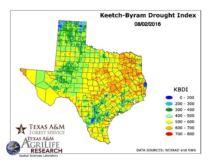
Thanks. Yeah the KBDI keeps creeping up despite the rains from last week. LOTS of orange covering the Montgomery County forests - what's left of them.
Re: August 2016: Looking toward the tropics?
Posted: Wed Aug 03, 2016 5:49 am
by Katdaddy
Hot SE TX weather through the weekend with a 20-30% chance of afternoon thunderstorms with high temps in the upper 90s. Not sure Snoopy would approve but the dog days of August are upon us. TS Earl is approaching hurricane strength and is forecast to become an 80MPH CAT 1 by landfall in Belize. We will have nil effects across SE TX thanks to the strong ridge in place. However with that said the peak of hurricane season is upon us and this morning's Hou-Gal NWS AFD make an excellent point:
Hopefully Earl is succeeding in knocking a bit of the rust off, and reminding people that despite the long hurricane drought in the Gulf of Mexico, everyone needs to have a plan and be prepared for tropical threats.
Re: August 2016: Looking toward the tropics?
Posted: Wed Aug 03, 2016 6:00 pm
by DoctorMu
Damn, it's hot.
Re: August 2016: Looking toward the tropics?
Posted: Wed Aug 03, 2016 7:29 pm
by unome
Re: August 2016: Looking toward the tropics?
Posted: Thu Aug 04, 2016 7:49 am
by Texaspirate11
Re: August 2016: Hot & Dry
Posted: Thu Aug 04, 2016 10:15 am
by jasons2k
Yeah, I remember reading the discussions last week and over the weekend, and they predicted this week to be hot & dry, with a return to a more moist pattern - at least typical 20-30% showers - starting back today. They even mentioned a few waves could gives us some more heavy rain threats. I haven't read the last few days, but it appears this has now changed for the worse. Other than a little break tomorrow, it looks like the hot & dry pattern is here for awhile as the ridge holds in place. Boo-hiss!
Re: August 2016: Looking toward the tropics?
Posted: Thu Aug 04, 2016 12:33 pm
by houstonia
This looks very neat. Thanks unome!