
August 2016: Rain Chances Continue.
-
TexasBreeze
- Posts: 942
- Joined: Sun Sep 26, 2010 4:46 pm
- Location: NW Houston, TX
- Contact:
I am ready for fall and coller weather, but not 83/89 type cold!!! At least with all the wetting rains and weaker ridge, I don't see upper 90's or 100's for our area next week. The se US ridge isn't the strongest for TX and lower maybe mid 90's will be enough for scattered storms each day. That same ridge could be very important for happenings on 99l for the future time.....
-
Skyguy
TexasBreeze wrote:I am ready for fall and coller weather, but not 83/89 type cold!!! At least with all the wetting rains and weaker ridge, I don't see upper 90's or 100's for our area next week. The se US ridge isn't the strongest for TX and lower maybe mid 90's will be enough for scattered storms each day. That same ridge could be very important for happenings on 99l for the future time.....
A chew toy for your mind, TexasBreeze:
http://spacecityweather.com/rinse-repea ... -se-texas/
-
Texaspirate11

- Posts: 1278
- Joined: Tue Dec 31, 2013 12:24 am
- Contact:
I don't know who the "SpaceCity Weather" person but in a nutshell: It's hurricane seasonSkyguy wrote:TexasBreeze wrote:I am ready for fall and coller weather, but not 83/89 type cold!!! At least with all the wetting rains and weaker ridge, I don't see upper 90's or 100's for our area next week. The se US ridge isn't the strongest for TX and lower maybe mid 90's will be enough for scattered storms each day. That same ridge could be very important for happenings on 99l for the future time.....
A chew toy for your mind, TexasBreeze:
http://spacecityweather.com/rinse-repea ... -se-texas/
everyone from Brownsville up through the East Coast should always be prepared.
Other than that, it's 10 days out, models will go wonky, people will predict this or that
but the bottom line: ya just got to be prepared.
Just because you're disabled, you don't have to be a victim
Be Weather Aware & Prepared!
Barbara Jordan Winner in Media
Disability Integration Consultant
Be Weather Aware & Prepared!
Barbara Jordan Winner in Media
Disability Integration Consultant


-
Katdaddy

- Global Moderator

- Posts: 2502
- Joined: Thu Feb 04, 2010 8:18 am
- Location: League City, Tx
- Contact:
A quiet weather morning across SE TX except for one isolated thunderstorm in Wharton County All the action stretches from Central TX into NTX where Flash Flood Watches are in effect with several Flash Flood Warnings ongoing.
The current satellite image shows a massive storm complex over Central TX drifting slowly ESE. A complex forecast for SE TX overnight and Sunday to due to mesoscale driven convection. The combination of a stalling front across N portions of SE TX, outflow boundaries, and shortwave trough near Del Rio will be part of equation for potential convection with heavy rains.
The current satellite image shows a massive storm complex over Central TX drifting slowly ESE. A complex forecast for SE TX overnight and Sunday to due to mesoscale driven convection. The combination of a stalling front across N portions of SE TX, outflow boundaries, and shortwave trough near Del Rio will be part of equation for potential convection with heavy rains.
- Attachments
-
-
- Screen Shot 2016-08-20 at 9.41.06 AM.png (371.06 KiB) Viewed 4666 times
hearing a few rumbles of thunder from the cell in NW Harris Co, might be moving fast though
http://weather.cod.edu/satrad/?type=E_T ... verDim=100
http://weather.cod.edu/satrad/?type=E_T ... verDim=100
Last edited by unome on Sat Aug 20, 2016 4:07 pm, edited 1 time in total.
Area Forecast Discussion
National Weather Service Houston/Galveston TX
1234 PM CDT Sat Aug 20 2016
.AVIATION...
Starting to see some sct shra/tsra develop with daytime heating. Away from any convection...mainly VFR conditions should persist for most of the afternoon. Do anticipate increasing precip coverage around the CLL/UTS terminals late in the day and tonight as precip currently to the north and west edge into SE Texas. Precip could be intermittently moderate to heavy at times there and may need some amendments there as trends/timing are better established. Metro airports should be on the southern periphery of much of the more sig rains during the overnight hours and am not currently anticipating many impacts there. However...may see an uptick in coverage beginning midmorning Sunday w/ heating and possible boundary interactions. 47
-
srainhoutx

- Site Admin

- Posts: 19616
- Joined: Tue Feb 02, 2010 2:32 pm
- Location: Maggie Valley, NC
- Contact:
Saturday afternoon briefing from Jeff:
Yet another heavy rainfall event for TX over the next 24-36 hours.
Factors are in place to produce an excessive rainfall event tonight into Sunday across portions of central TX possibly as far east as our western and northern counties which have just been included in a Flash Flood Watch. A stalling frontal boundary, surface trough/warm core surface low WSW of Austin and copious moisture with PWS of 2.2-2.5 inches all support the development and slow movement of a well organized MCS over SW/C TX this evening which will likely continue into much of the night and into Sunday. Significant rainfall is likely along the I-35 corridor tonight which may result in rapid flash flooding of small creek and rivers.
Main question is how far east and south this organized heavy rainfall moves into SE TX. Models generally keep the heaviest rainfall near our western border into Sunday morning and this is certainly possible given the expected slow storm motions and 500-200mb ridging attempting to build over SE TX from the ESE. However as we have seen with many of these events, the meso scale (outflow boundaries) like to take over and drive convection to the east and south many times deeper into SE TX. Additionally, the deeper moisture channel will be across a larger part of SE TX on Sunday and with heating and boundaries approaching from the N and W the chances for heavy rainfall may move deeper into the region.
High rain chances look to continue into Monday before upper level ridging briefly builds over the region Tuesday and Wednesday. A strong mid level trough approaches the central US late next week and may drive yet another front into the state with increasing rain chances again. Also tropical wave 99L will be likely nearing the Lesser Antilles at this same time and the approaching mid/upper level trough will likely result in strong downstream ridging over the US east coast possibly keeping 99L moving on a more W or WNW course just north of the Caribbean Islands. Latest global models are showing some weak consistency in the development of 99L somewhere in and near the Bahamas toward the end of next week.
Carla/Alicia/Jerry(In The Eye)/Michelle/Charley/Ivan/Dennis/Katrina/Rita/Wilma/Humberto/Ike/Harvey
Member: National Weather Association
Facebook.com/Weather Infinity
Twitter @WeatherInfinity
Member: National Weather Association
Facebook.com/Weather Infinity
Twitter @WeatherInfinity
-
Portastorm

- Posts: 800
- Joined: Wed Feb 03, 2010 3:04 pm
- Location: Southwest Austin/Oak Hill, TX
- Contact:
Looks like a long night ahead for us in the I-35 corridor Austin/San Antonio. We're looking at the likelihood of 6-8" of rain with as much as 15" possible in isolated spots. This on already saturated ground. Very sobering language coming out of the EWX office as well as NOAA's WPC excessive rainfall desk. Hope folks pay attention and heed all warnings.
sobering excessive rainfall from WPC:Portastorm wrote:Looks like a long night ahead for us in the I-35 corridor Austin/San Antonio. We're looking at the likelihood of 6-8" of rain with as much as 15" possible in isolated spots. This on already saturated ground. Very sobering language coming out of the EWX office as well as NOAA's WPC excessive rainfall desk. Hope folks pay attention and heed all warnings.

...TEXAS...
growing very concerned about the ingredients in place that would support a convectively enhanced mid level vortex or mcv... and the associated very strong trend toward excessive rainfall amounts totaling 10 to 15 inches in most of the high resolution guidance. hand analysis of 500 mb reveals a height depression over south texas near del rio... associated with cyclonic curvature seen in radar loops at 19z. this feature is embedded within a plume of tropical moisture that lifted into northern mexico and south texas over the past few days and is now in a region of weak steering flow. the larger scale pattern related to a healthy northern stream trough and sub-tropical ridging along the gulf coast favors persistent upper difluence in the vicinity of the mcv... and also sustained low level inflow. this situation would appear to be ripe for a significant flash flood event... especially given the tendency for this style of event to occur in the texas hill country. therefore... it was not too surprising when the canadian gem regional... the first arriving hi-res guidance... depicted a very wet... nearly stationary mcv and likely flash flood event over the san antonio / austin area. this was followed up by very strong and similar qpf signals in the ncep hi-res windows and nssl wrf. the global models also have heavy rain... especially the ecmwf. the hi-res models and ecmwf support the notion of a 10-plus inch rainfall event occurring from this evening through early sunday. the qpf signal is organized... suggesting some breadth to the extreme rain totals... perhaps affecting multiple counties... rather than being very isolated.
based on the overwhelming model signal and history of rapid hydrologic response in this area... coordinated with texas local offices to upgrade not only to moderate risk... but also to a small high risk area centered around san antonio / austin. placement of the qpf maximum is not of extremely high confidence... but wpc forecasters using independent methods on the night and day shift came up with the same answer for location... which is supported in particular by the wrf-arw... which tends to perform well in south texas. also noted the wrf-arw and wrf-nmm qpf signal indicating nearly 150 percent of the one percent annual exceedance probability or recurrence interval rainfall. with perhaps more people outdoors / on the roads on a saturday night... felt it was prudent to upgrade to high risk to send a clearly heightened message. thanks wfo ewx... fwd... crp... hgx...and southern region for coordination.
-
Katdaddy
- Global Moderator
- Posts: 2502
- Joined: Thu Feb 04, 2010 8:18 am
- Location: League City, Tx
- Contact:
Parameters are coming together for major flooding in and around San Antonio and Austin as well as the surrounding Hill Country tonight into Sunday evening. If you have family, friends, and co-workers in that part of state, please make sure they are weather aware. The combination of weak sagging frontal/outflow boundary, Mesoscale Convective Vortex, and mid level disturbance moving out of MX will combine with a deep tropical airmass. A warm core rain event will be possible overnight. Warm core rain events are known for very intense and high rainfall totals. The MCV can be easily seen on satellite this evening near the Austin area. The San Antonio-Austin NWS state it well in this afternoon's Area Forecast Discussion:
...Significant rainfall and flooding probable tonight through
Sunday evening...
...Significant rainfall and flooding probable tonight through
Sunday evening...
- Attachments
-
-
-
worrybug
Do you personally believe that Houston and surrounding areas will experience the same kind of heavy rain that is predicted for Austin and San Antonio? Or are you just saying this for safety's sake?srainhoutx wrote:Saturday afternoon briefing from Jeff:
Main question is how far east and south this organized heavy rainfall moves into SE TX. Models generally keep the heaviest rainfall near our western border into Sunday morning and this is certainly possible given the expected slow storm motions and 500-200mb ridging attempting to build over SE TX from the ESE. However as we have seen with many of these events, the meso scale (outflow boundaries) like to take over and drive convection to the east and south many times deeper into SE TX. Additionally, the deeper moisture channel will be across a larger part of SE TX on Sunday and with heating and boundaries approaching from the N and W the chances for heavy rainfall may move deeper into the region.

Bow echo closing in on CLL. A bit of a hook near Brenham. Rotation possible, but right now expect some straight line winds.
Also keep an eye out for potential flash flooding as the low moves ENE tonight.


Also keep an eye out for potential flash flooding as the low moves ENE tonight.

-
worrybug
DoctorMu wrote:Bow echo closing in on CLL. A bit of a hook near Brenham. Rotation possible, but right now expect some straight line winds.
Also keep an eye out for potential flash flooding as the low moves ENE tonight.
When does this bow echo move into Houston, Doctor Mu? What kind of winds should I expect in my suburb?
The bow echo is gone and we now see central circulation of the MCV (Mesoscale Convective Vortex. You can see the center approaching Brazos County. We're seeing a fair amount of lightning
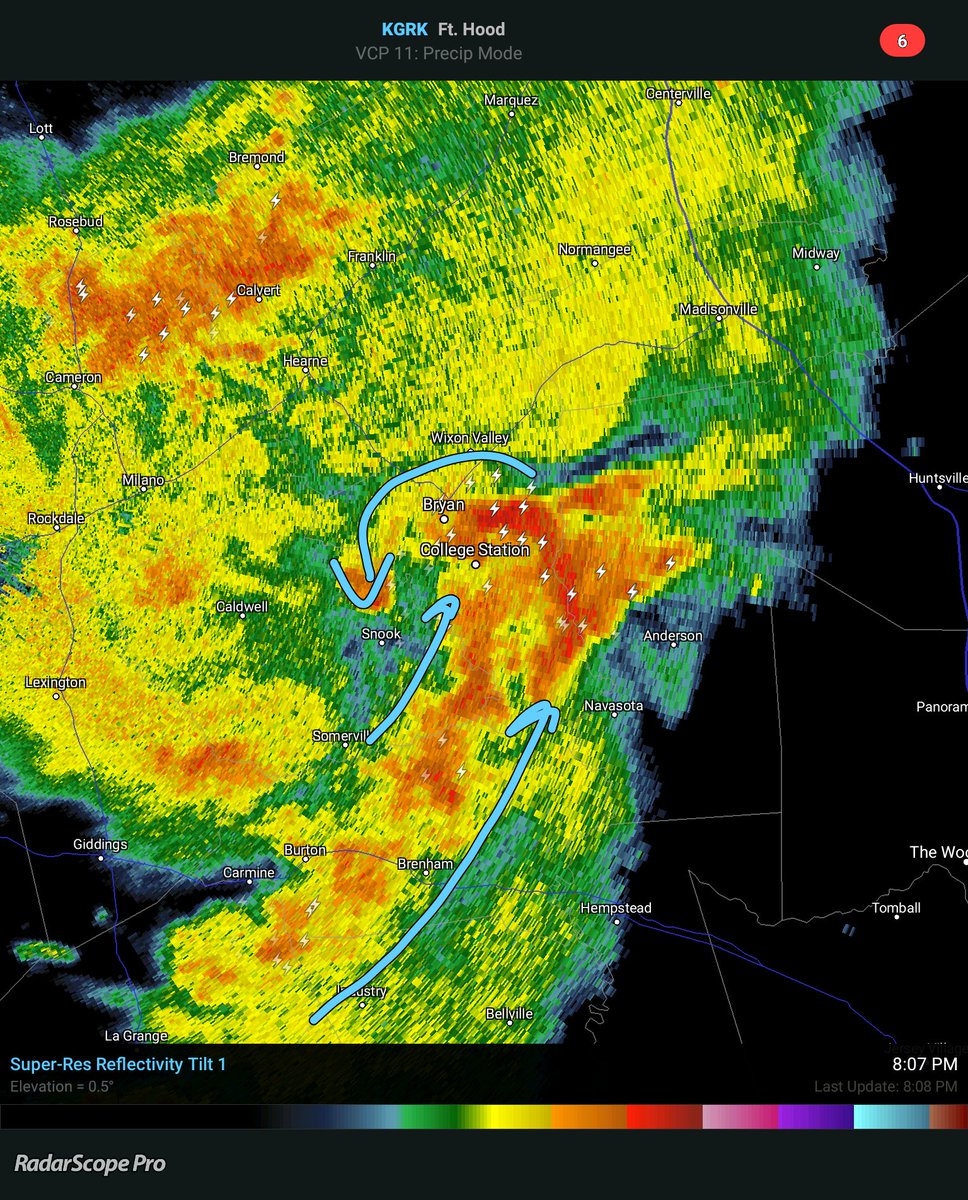
Houston may see a straight line of storms as the center of the MCV stays north of HOU
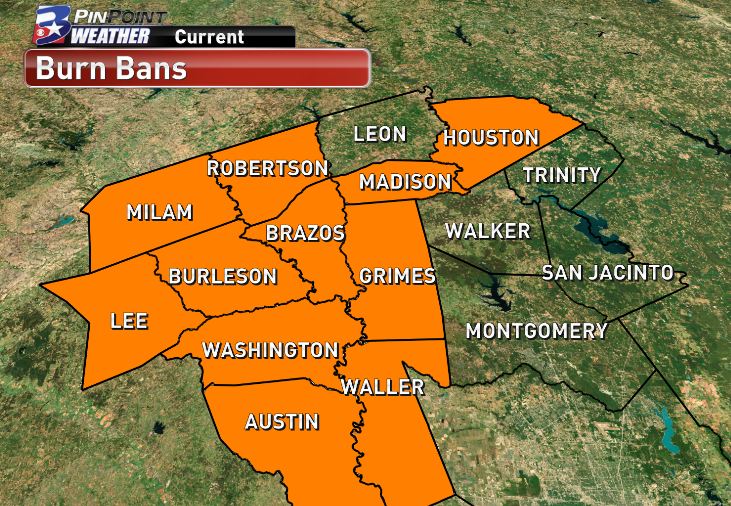
From burn ban to flash flood watch in less than 4 days. Welcome to Texas!
Houston may see a straight line of storms as the center of the MCV stays north of HOU
From burn ban to flash flood watch in less than 4 days. Welcome to Texas!
-
worrybug
DoctorMu wrote:The bow echo is gone and we now see central circulation of the MCV (Mesoscale Convective Vortex. You can see the center approaching Brazos County. We're seeing a fair amount of lightning
Houston may see a straight line of storms as the center of the MCV stays north of HOU
From burn ban to flash flood watch in less than 4 days. Welcome to Texas!
Are you saying we're going to get severe storms here in a few hours, Doc?
The heavy action should remain north of Harris Co, but expect rain later tonight. Flash Flood for NW counties.
http://www.goes.noaa.gov/GSSLOOPS/ecwv.html
Area Forecast Discussion
National Weather Service Houston/Galveston TX
634 PM CDT Sat Aug 20 2016
.AVIATION...
Not a lot of confidence with the 21/00Z TAFs. A northeast to southwest
oriented line of showers and thunderstorms is moving into the CLL area
early this evening with the best coverage currently in line with the
coldest cloud tops on IR satellite imagery. Cloud tops are cooling with
the activity off to the southwest, and these storms are in line to eventually
move into the CLL and UTS areas this evening. Through tomorrow morning,
generally have VCTS/TSRA for CLL and UTS, and VCSH/-RA for locations
further to the south. During the day tomorrow, going with SHRA to the
north and TSRA to the south. There are most likely going to be lots
of amendments tonight and tomorrow as this storm system evolves. Mainly
MVFR/IFR ceilings and visibilities are anticipated to develop as storms
move into the area. 42
&&
.PREV DISCUSSION... /ISSUED /
DISCUSSION...
A series of upper level shortwave troughs will move through the
central and eastern portions of the state tonight and Sunday. With
a moisture tap off of the Pacific in the mid and upper levels, and
low-level moisture form the Gulf of Mexico, widespread showers and
thunderstorms will be possible over portions of the forecast area
both periods.
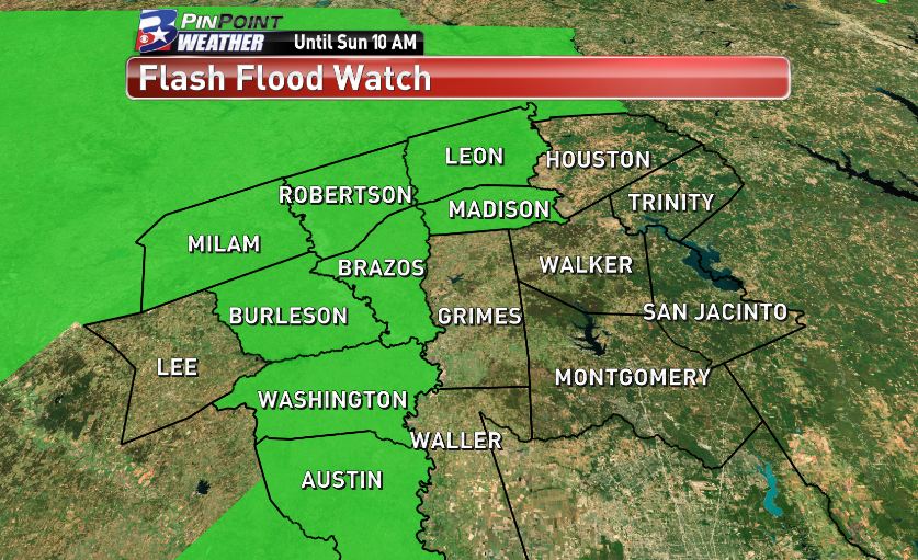
Issuing a flash flood watch for the far northern and western
counties through mid morning on Sunday: Houston, Madison, Brazos,
Burleson, Washington, Austin, and Colorado. The main event for
heavy rainfall tonight and Sunday will most likely be west of the
CWA over the Hill Country. An MCV currently moving northeastward
across the Hill Country should bring more widespread chances for
showers and thunderstorms into the western and northern portions
of the forecast area. Water Vapor showed another shortwave trough
moving across northern Mexico which should help trigger additional
thunderstorms later tonight. Model rainfall amounts for Southeast
Texas for tonight through Sunday range from 1 to 3 inches with
isolated higher amounts generally along and west of a line from
Crockett to College Station to Columbus. The most likely time
period for locally heavy rainfall will be this evening through mid
Sunday morning.
Good chances for rainfall continue into Monday with the corridor
of deep layer moisture finally moving away from the area by Monday
night as the mid and upper level ridge build into the state from
the east. This will in turn mean lower rain chances and warmer
temperatures during the mid and latter parts of the upcoming week.
http://www.goes.noaa.gov/GSSLOOPS/ecwv.html
Area Forecast Discussion
National Weather Service Houston/Galveston TX
634 PM CDT Sat Aug 20 2016
.AVIATION...
Not a lot of confidence with the 21/00Z TAFs. A northeast to southwest
oriented line of showers and thunderstorms is moving into the CLL area
early this evening with the best coverage currently in line with the
coldest cloud tops on IR satellite imagery. Cloud tops are cooling with
the activity off to the southwest, and these storms are in line to eventually
move into the CLL and UTS areas this evening. Through tomorrow morning,
generally have VCTS/TSRA for CLL and UTS, and VCSH/-RA for locations
further to the south. During the day tomorrow, going with SHRA to the
north and TSRA to the south. There are most likely going to be lots
of amendments tonight and tomorrow as this storm system evolves. Mainly
MVFR/IFR ceilings and visibilities are anticipated to develop as storms
move into the area. 42
&&
.PREV DISCUSSION... /ISSUED /
DISCUSSION...
A series of upper level shortwave troughs will move through the
central and eastern portions of the state tonight and Sunday. With
a moisture tap off of the Pacific in the mid and upper levels, and
low-level moisture form the Gulf of Mexico, widespread showers and
thunderstorms will be possible over portions of the forecast area
both periods.
Issuing a flash flood watch for the far northern and western
counties through mid morning on Sunday: Houston, Madison, Brazos,
Burleson, Washington, Austin, and Colorado. The main event for
heavy rainfall tonight and Sunday will most likely be west of the
CWA over the Hill Country. An MCV currently moving northeastward
across the Hill Country should bring more widespread chances for
showers and thunderstorms into the western and northern portions
of the forecast area. Water Vapor showed another shortwave trough
moving across northern Mexico which should help trigger additional
thunderstorms later tonight. Model rainfall amounts for Southeast
Texas for tonight through Sunday range from 1 to 3 inches with
isolated higher amounts generally along and west of a line from
Crockett to College Station to Columbus. The most likely time
period for locally heavy rainfall will be this evening through mid
Sunday morning.
Good chances for rainfall continue into Monday with the corridor
of deep layer moisture finally moving away from the area by Monday
night as the mid and upper level ridge build into the state from
the east. This will in turn mean lower rain chances and warmer
temperatures during the mid and latter parts of the upcoming week.
worrybug wrote:DoctorMu wrote:
Are you saying we're going to get severe storms here in a few hours, Doc?
The MCV (rotating blob of heavy rain) should stay north of Houston. A trailing line of storms will provide rain later tonight, but NOAA does not anticipate severe weather. Navasota, College Station, Huntsville are in the path of the MCV...