
JUNE 2016: Showers/Storms Possible
-
srainhoutx

- Site Admin

- Posts: 19615
- Joined: Tue Feb 02, 2010 2:32 pm
- Location: Maggie Valley, NC
- Contact:
Shorter fuse quantitative precipitation forecast suggest possibly 6+ inches mainly near the Edwards Plateau, San Antonio, Hill Country area with some increase across portions of SE Texas.
- Attachments
-
Carla/Alicia/Jerry(In The Eye)/Michelle/Charley/Ivan/Dennis/Katrina/Rita/Wilma/Humberto/Ike/Harvey
Member: National Weather Association
Facebook.com/Weather Infinity
Twitter @WeatherInfinity
Member: National Weather Association
Facebook.com/Weather Infinity
Twitter @WeatherInfinity

Theres a slight disagreement between the GFS and Euro/Canadian models. The GFS has most of the rain falling across the central portions of the state,while the Canadian and Euro models have the heavy precipitation more widespread,which both the Euro and Canadian models bring in multiple slow moving squall lines/storm complexes into Southeast Texas over the next few days.
-
srainhoutx
- Site Admin
- Posts: 19615
- Joined: Tue Feb 02, 2010 2:32 pm
- Location: Maggie Valley, NC
- Contact:
The Weather Prediction Center updated Day 2 and 3 Excessive Rainfall Outlooks inching closer. Worrisome to already see a Moderate Risk across the Hill Country into S Central Texas. The Slight Risk has expanded East to include SE Texas.
- Attachments
-
Carla/Alicia/Jerry(In The Eye)/Michelle/Charley/Ivan/Dennis/Katrina/Rita/Wilma/Humberto/Ike/Harvey
Member: National Weather Association
Facebook.com/Weather Infinity
Twitter @WeatherInfinity
Member: National Weather Association
Facebook.com/Weather Infinity
Twitter @WeatherInfinity
-
srainhoutx
- Site Admin
- Posts: 19615
- Joined: Tue Feb 02, 2010 2:32 pm
- Location: Maggie Valley, NC
- Contact:
Forecaster Scott Overpeck of NWS Houston/Galveston issues a great Area Forecast Discussion explaining exactly why we have been very concerned regarding the potential of yet another heavy rainfall event. It is well worth reading and explains the complicated and complex forecast ahead. Stay tuned folks. With so many of our neighbors already suffering and at least 8 confirmed deaths from the Flood of last Thursday and Friday, we will continue to Update very regularly.
Area Forecast Discussion
National Weather Service Houston/Galveston TX
402 PM CDT TUE MAY 31 2016
.DISCUSSION...
Water vapor imagery shows a short wave trough moving into Texas
which has allowed for widespread thunderstorm activity from the NW
Hill Country through central Texas. This thunderstorm activity was
producing very heavy rainfall in central Texas as it was located
within an axis of higher moisture running from south Texas through
north central Texas. Some of these storms have produced 2 inches
of rain in an hour. Short range hi-res model guidance shows some
of this activity possibly reaching the Brazos Valley later this
evening before dissipating. The forecast will keep 30-40 percent
chances of thunderstorms in the forecast. The main concerns will
be heavy rainfall but moderate instability may allow for a
strong/severe storm with hail/downburst wind threat.
Day 2-5...Wednesday to Saturday...
This will be the critical time frame for a heavy rainfall threat
over SE Texas. There is overall high confidence that there will be
rainfall during this time frame across the area but low confidence
in where exactly higher rainfall amounts will occur. An upper
level low over the Desert SW and NW Mexico will move across the
southern Rockies into Texas by Thursday into Friday. This upper
level low will be slow moving across the state and likely stall
over the Texas Gulf coast and SE Texas on Saturday. An upper
level trough over the upper Midwest will drop into the Ohio River
Valley on Sunday. This will help shear out the upper low over the
Gulf Coast for the weekend. With this NW flow aloft, believe it or
not, there will actually be a weak front that pushes through into
the Gulf Sunday into Monday. Still some uncertainty as to if this
front actually pushes through but noteworthy nonetheless.
This means that Wednesday through Friday the upper level pattern
will be very conducive for heavy rainfall. With the upper level
low moving towards the area slowly, upper level winds should
decrease and then allow for slow storm motions of under 20 knots.
Precipitable water values will range from 1.8 to 2.0 inches during
this time. There will also be good inflow from the Gulf with 850mb
winds of 20 to 30 knots supporting precipitable water values
around 2 inches for Thursday/Friday. By Sunday precipitable water
values should be decreasing with possible front passage and likely
bring an end to rain chances for early next week. Jet stream flow
will become increasingly diffluent and divergent over much of the
area which would limit any capping and increase large scale ascent
over the region. A frontal boundary pushing into north Texas
tonight may not play much of a role in focusing convection for SE
Texas but could be where surface low pressure forms along in
response to the upper level low moving across Texas. This boundary
may contribute to heavy rainfall over central Texas tomorrow and
Thursday. Rainfall amounts will be tough to nail down but looking
at 2 to 4 inches of rain for the whole area for the next 5 days.
The problem will be identifying areas that may be susceptible to
isolate higher amounts. This is where the mesoscale evolution is
critical but also involves the most non-linearity. Basically
mesoscale processes introduce quite a bit of uncertainty in the
forecast and where the 2 to 4 inches of rainfall become 6 to 8
inches rather quickly especially if higher rain rates can be
achieved. Mesoscale QPF forecasting will be the main problem as
evidenced by recent heavy rainfall/flood events. Flash flood watch
will likely be needed but will wait to see how the atmosphere
evolves the next 24 to 36 hours. Watch may be issued sometime
tomorrow likely for the Thursday/Friday time frame.
Overpeck
Carla/Alicia/Jerry(In The Eye)/Michelle/Charley/Ivan/Dennis/Katrina/Rita/Wilma/Humberto/Ike/Harvey
Member: National Weather Association
Facebook.com/Weather Infinity
Twitter @WeatherInfinity
Member: National Weather Association
Facebook.com/Weather Infinity
Twitter @WeatherInfinity


-
houstonia
- Posts: 138
- Joined: Sun Jun 14, 2015 6:51 pm
- Location: Houston, Texas (Southwest side; Sharpstown)
- Contact:
11:00 update from Jeff:
***Significant flash flood and river flood threat across TX***
***Potentially dangerous flash flood event for TX next several days***
Hydro situation across this state is dire and additional potentially excessive rainfall is going to push area river systems and lakes to beyond their breaking point. The systems are just overloaded and given what has transpired this afternoon across the Hill Country (4-6 inches of rainfall) flooding is almost ineveitable across this state over the next 5 days.
I am extremely concerned with the potential of this system to drop copious rainfall leading to devastating flooding.
Discussion:
Upper level system will move into TX on Wednesday and park over the state for the next 5 days. Very high tropical moisture levels will surround this upper level feature and there is the increasing potential for this system to begin to take on tropical warm core charateristics which is deeply concerning. Such slow moving systems in the past across this state in the warm season summer months have produced devastating flood events even with dry conditions before onset. Warm core systems generally like to focus extreme rainfall near their circulation cores during the overnight hours and these rains can be extraordinary…TS Allison…TS Charley…TS Frances. Such systems have produced some of the greatest floods this state has ever experienced.
Expect numerous rounds of thunderstorms to onset by Wednesday afternoon. Storm motions really begin to slow down into Wednesday night through Friday with less than 20kts of forward motion. 850mb inflow of 20-30kts is really favorable for providing a rich low level flow of moisture…combine that with strong and near continuous upper level divergence and you have another classic flash flood setup over this state.
Will go with widespread rainfall amounts of 2-4 inches through Friday…but am almost certain there is going to be significantly higher amounts. Confidence is poor to where these large totals may occur…but right now will favor areas W of I-45 and N of I-10, or the area that has been devastated over the last 6 weeks with flooding. This also highly impacts the Brazos and Colorado basins which are already dealing with devastating flooding. Think storm totals of 10-15 inches are certainly possible in isolated locations especially over our western counties into central TX. Where such rainfall occurs on already very saturated grounds will result in catastrophic flooding. There is just no skill at this range of predicting where these really big totals may occur.
Residents across the entire region should be prepared for significant flash flooding and watershed flooding over the next 5 days. React immediately to rising water and expect flooded roadways. Never drive into high water…let me say this again NEVER DRIVE INTO HIGH WATER!!!
Brazos River:
Brazos River has risen past the expected forecast today of 53.5 ft and is currently at 54.3 ft this evening and still rising which is smashing the old 1994 record. Flooding across Fort Bend into Brazoria County is devastating. Water is against all the levees in Fort Bend County and back water flooding is starting to cut-off some subdivisions. Large sections of Fort Bend County are flooded with water in parts of Rosenberg and Valley Lodge many feet deep in homes. The river is across the basin divide into Oyster Creek. This situation is Fort Bend and Brazoria Counties moving forward is dire with additional heavy rainfall forecast. Levee protected subdivisions will have to pump additional rainfall as gravity flow into the river is not possible at this time due to the very high levels which could lead to flooding within these subdivisions if rainfall rates exceed to pumping capabilities.
- Attachments
-
- add image
-
Andrew
- Site Admin
- Posts: 3440
- Joined: Wed Feb 03, 2010 9:46 pm
- Location: North-West Houston
- Contact:
GFS and ECMWF are in pretty good consensus that through the next 5 days most areas should see at least 2-4 inches of rain. The key here is the higher totals. Global and mesoscale models indicate that training will be possible everyday of the week from here on out as storms rotate around the mid level low that will stall over the state. For instance, if going by the ECMWF verbatim, 6-8 inches could occur just to the Northwest of Harris County. The GFS thinks that will occur further north across central and northern Texas. So overall expect a widespreasd 2-4 inches but some areas will probably at least double that over the next couple days. Looking at the HRRR and SPC mesoanalysis, it is a little concerning to see a surface boundary currently setup over SE Texas. This could help focus storms as we head into the afternoon.
For Your Infinite Source For All Things Weather Visit Our Facebook
-
srainhoutx
- Site Admin
- Posts: 19615
- Joined: Tue Feb 02, 2010 2:32 pm
- Location: Maggie Valley, NC
- Contact:
As Jeff mentioned in his update above, should the transition to a warm core system occur, devastating flooding could become a real possibility. The overnight guidance continues to struggle with the evolution of the upcoming sensible weather pattern over the next 5 to 7 days. A new fly in the ointment is yet another upper low moving across Southern California this weekend and the potential of some tropical mischief moving out of the NW Caribbean Sea into the Southern Gulf associated with a monsoonal trough of low pressure enhanced by a favorable MJO pulse and a robust Convectively Coupled Kelvin Wave meaning rising air that aids in the development of tropical thunderstorms. The morning updated quantitative precipitation forecast may be too optimistic regarding the precipitation amounts. With our Rivers, watersheds and Lakes filled to capacity, will err on the side of extreme caution since so many of our neighbors are suffering. Fingers crossed the flooding does not materialize and we escape with minimal effects.
- Attachments
-
Carla/Alicia/Jerry(In The Eye)/Michelle/Charley/Ivan/Dennis/Katrina/Rita/Wilma/Humberto/Ike/Harvey
Member: National Weather Association
Facebook.com/Weather Infinity
Twitter @WeatherInfinity
Member: National Weather Association
Facebook.com/Weather Infinity
Twitter @WeatherInfinity
-
srainhoutx
- Site Admin
- Posts: 19615
- Joined: Tue Feb 02, 2010 2:32 pm
- Location: Maggie Valley, NC
- Contact:
The morning Area Forecast Discussion advertises what we have been watching and discussing since the Memorial Day Holiday Weekend. Please take time to read the information provided by our National Weather Service Office in SE Texas. It explains the possibilities of this very complex and complicated forecast and why we have been very concerned with the possibility of another heavy rainfall event for our Region.
Area Forecast Discussion
National Weather Service Houston/Galveston TX
456 AM CDT WED JUN 1 2016
.DISCUSSION...
Southeastern Texas is readying itself for another few days of
precipitation brought on by periods of locally moderate to heavy
rainfall that will likely induce or aggravate regional flash and
river flooding. All of the synoptic ingredients are in place, from
the gradual spreading of the upper levels as jet level winds become
more diffulent just ahead of the southwestern-settling mid to upper
low to the stout lower to mid level southeasterly 20-35 knot inflow
feeding inland convection with near 2 inch precipitable waters.
The devil is in the details as they say and this couldn`t be more
true of a idiom than for us over the next several days. Yes,
confidence is mounting that many across the region will experience
a round or three of impressive rainfall (rates) that will again
produce flooding and quite possibly various communities will be
dealing with wind damage from either localized wet downbursts or
weak tornadoes from passing strong thunderstorm clusters. As is
the case with all of these anticipated potential severe weather
events...the question of the exact timing and location of the most
intense weather will go unanswered until either right before its
passage or during the heat of battle itself. Although the vicinity
(unfortunately southwestern-positioned) upper low and subsequent
shortwave disturbances rotating around this main feature will
ultimately be the impetus to inclement weather, it will be the
mesoscale that determines the when and the where of the most
severe rainfall and wind. Or, in other words, it will be that
prior convection that drives future convective behavior and, if we
can better pinpoint this on a 6 hour time line, then we may be
able to more accurately convey a relatively higher confidence with
a 12,or even 24, hour forecast.
The target days for the highest rainfall will be from as early as
today through as late as Saturday afternoon. This is the period in
which the upper low currently digging down over the lower U.S.
Southwest and the northern Mexico Providences of Sonora and
Chihuahua will nestle itself over Texas, particularly over eastern
or south central state. With the highly moist `condition`ally
unstable air mass already in place over the region, this scenario
is the worse possible for us as it places eastern Texas under the
best upper exhaust pattern for series of disturbances (the `conditional`)
to generate lift and maintain an environment conducive to the
formation of continual clusters of thunderstorms to slowly travel
(train) over the area. Not expecting overall storm motion to be
all that fast within a forecast weakly steered lower layer. As of
now, the forecast calls for likely rain/storm chances commencing
today and persisting through the weekend. There will be periods of
either very light or no precipitation, especially if an MCS travels
across the CWA and creates subsidence in its wake. A model and
national center blend equates to an areawide 5 day QPF of between
4 to 5 inches, locally higher with amounts of greater than 10
inches certainly not out of the question. Of course, it will be
those 1 inch amounts over 15 minutes across more urbanized landscapes
that will be of the highest threat versus double digit rainfall
over a span of several days.
On a major side note...the city (IAH) has not yet recorded a 90F
degree day this year. If this forecast pans out and overcast with
rainfall plagues the region through the weekend, then the city
would likely not meet 90F for the remainder of the week. This
would place 2016 in the Top 5 if 90F was not met by Sunday (the
latest day was on June 15th, 1897). 31
Carla/Alicia/Jerry(In The Eye)/Michelle/Charley/Ivan/Dennis/Katrina/Rita/Wilma/Humberto/Ike/Harvey
Member: National Weather Association
Facebook.com/Weather Infinity
Twitter @WeatherInfinity
Member: National Weather Association
Facebook.com/Weather Infinity
Twitter @WeatherInfinity
-
BlueJay
- Posts: 938
- Joined: Tue Mar 04, 2014 10:47 am
- Location: Alden Bridge-The Woodlands, Texas
- Contact:
I looked back at the history of posts to compare the temperatures in 2011-that infamous year of drought.
I found this post by Ptarmigan:
Postby Ptarmigan » Sun Jun 05, 2011 5:26 pm
Today, Houston hit a record high of 105 at Intercontinental Airport. The record high is 109 set on September 4, 2000. One wonders is it possible for Houston to hit +110 or even 120? The answer is yes, especially with all the concrete and development in Houston and surrounding area. Houston is way more likely to see 100 degree days than single digit frigid temperatures. Only four instances of that happening, twice in 1899, 1930, and 1989. Also, Houston is more likely to see 100 degree days than below 20 days in Houston. However, some summers do not see 100 degree days, last happened in 1997.
viewtopic.php?f=2&t=583
User avatar
Ptarmigan
Statistical Specialist
Statistical Specialist
Posts: 2784
Joined: Wed Feb 03, 2010 8:20 pm
We were concerned about hitting 100+ temperatures in early June 2011 and now we have not even hit 90F!
Thank you again to all who post! I really enjoy and benefit from this site.

The HGX Office is now prediction 4-5 inches of rain areawide, with isolated areas potentially seeing up to 10 inches.
We should all be really concerned per Houstonia's post from Jeff Linder about downstream flooding, particularly the Brazos River.


We should all be really concerned per Houstonia's post from Jeff Linder about downstream flooding, particularly the Brazos River.

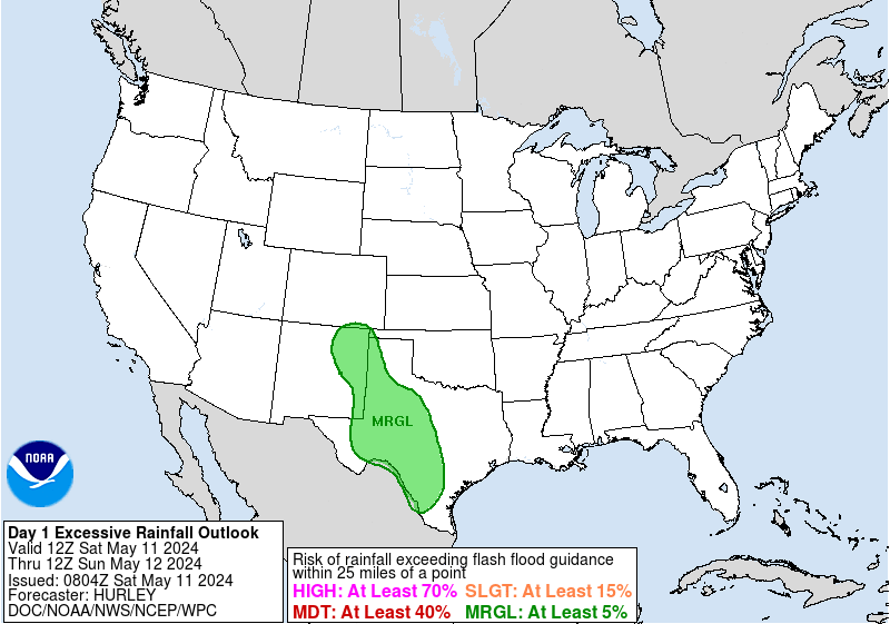
EXCESSIVE RAINFALL DISCUSSION
NWS WEATHER PREDICTION CENTER COLLEGE PARK MD
1058 AM EDT WED JUN 01 2016
...VALID 15Z WED JUN 01 2016 - 12Z THU JUN 02 2016...
...REFERENCE AWIPS GRAPHIC UNDER...DAY 1 EXCESSIVE RAINFALL...
SLIGHT RISK OF RAINFALL EXCEEDING FFG TO THE RIGHT OF A LINE FROM
15 NNW SRC 20 SSE PBF 20 NW AEX 15 WNW 7R5 25 SW BPT 20 SW GLS
10 ESE KRP 30 WNW KOPM 20 E BRO 15 WSW MMMA 55 W MFE 25 W MMNL
25 SSW DRT 35 SE 6R6 30 NW 6R6 25 N FST 35 WNW INK 10 WSW CNM
15 SE SRR 50 W CVS 40 SE CVN 15 E PVW 45 W CSM 20 SE WDG
30 SE JLN 10 ENE FLP 15 NNW SRC.
SLIGHT RISK OF RAINFALL EXCEEDING FFG TO THE RIGHT OF A LINE FROM
10 S PGV 10 SSW ECG 15 NE FFA 15 ENE HSE 15 S MRH 10 WSW ILM
DPL 10 S PGV.
MODERATE RISK OF RAINFALL EXCEEDING FFG TO THE RIGHT OF A LINE FROM
25 NW CNW 20 SE TRL 10 SSW 4F4 30 NE OCH 20 SE LFK 25 ENE CXO
30 SSE 11R 20 WSW VCT 20 ESE BKS 25 NW MFE 55 SSW HBV LRD
40 SSE MMPG 15 SSE DLF 25 NW DRT 25 E 6R6 45 WSW E29 25 NW JCT
35 SSE BWD 25 NW CNW.
..SOUTHERN PLAINS...
IT MAY BE SOME TIME BEFORE HEAVY RAIN REDEVELOPS TOWARD CENTRAL
AND DEEP SOUTH TEXAS. EXPECT THAT WITH ANOTHER DIURNAL HEATING
CYCLE...AN MCS WILL GRADUALLY DEVELOP IN THE STRONGLY DIFLUENT
UPPER JET REGION OVER NORTHERN MEXICO AND SOUTHWEST TEXAS...WITH
EVENTUAL MOTION INTO WHAT SHOULD BE A REPLENISHED AXIS OF AT LEAST
WEAK TO MODERATE INSTABILITY FROM THE HILL COUNTRY SOUTHWARD. THIS
NOTION SUPPORTS THE MODERATE RISK THAT HAD PREVIOUSLY BEEN IN
PLACE. WE ARE ALSO CONCERNED ABOUT THE CLUSTERS OF STORMS FORMING
WITHIN WARM ADVECTION AS A LOW AMPLITUDE TROUGH SLIDES INTO EAST
TEXAS AND TOWARD ARKANSAS AND LOUISIANA. FLOW IS RELATIVELY
WEAK...SO THIS CONVECTION MAY REMAIN RAGGED...BUT THE HRRR
SUGGESTS DECENT COVERAGE OF LOCALLY HEAVY DOWNPOURS...AND SOME OF
THIS REGION HAS SEEMINGLY UNPRECEDENTED WET ANTECEDENT CONDITIONS.
THEREFORE...WILL EXPAND THE MODERATE RISK OVER INTO EAST
TEXAS...REMAINING JUST NORTH OF THE IMMEDIATE HOUSTON
METRO...ALTHOUGH ISOLATED HEAVY DOWNPOURS ARE CERTAINLY EXPECTED
ALL THE WAY TO THE COAST...AS WAS ALREADY OCCURRING THIS MORNING.
ANOTHER POTENTIAL FOCUS IS THE SURFACE BOUNDARY THAT HAD STALLED
IN OKLAHOMA BACK TO THE EASTERN TEXAS PANHANDLE. A DIFLUENCE
MAXIMUM IS DEPICTED HERE IN THE RAP AND GFS...ALMOST A COUPLED JET
STRUCTURE...WITH CORRESPONDING QPF SIGNAL FROM MOST MODELS. EXPECT
THIS ACTIVITY WILL BE SMALLER IN SCALE...BUT CELL MOTIONS ARE
FORECAST AT ONLY ZERO TO TEN KNOTS...CAUSING CONCERN FOR FLASH
FLOODING ALONG THE BOUNDARY.
WE CARRIED THE SLIGHT RISK BACK WESTWARD TO CAPTURE THE AREA
AROUND THE NORTH SIDE OF THE SOUTHWEST U.S. UPPER LOW...AFFECTING
NM/TX. PART OF THIS WAS MOTIVATED BY THE 06Z NAM CONUS
NEST...WHICH OFFERED ONE OF THE BETTER SOLUTIONS WITH RESPECT TO
EARLY MORNING TRENDS. A RELATIVE MINIMUM OF DEEP LAYER ASCENT IS
FORECAST IN THE RED RIVER VALLEY...BUT WILL KEEP THIS AREA...AND
MUCH OF NORTH TEXAS...IN AT LEAST A SLIGHT RISK OF EXCESSIVE
RAIN...AS THERE ARE INDICATIONS ASCENT WILL INCREASE LATER TONIGHT
WITH A SLOW DEEPENING OF LOW PRESSURE ALONG A PRE-EXISTENT MID
LEVEL SHEAR AXIS OUT AHEAD OF THE SOUTHWEST TEXAS JET DIFLUENCE
MAXIMUM.
~~~When Thunder Roars Go Indoors~~~
~~~Turn Around Don't Drown~~~
~~~Run From The Water, Hide From The Wind~~~
~~~Turn Around Don't Drown~~~
~~~Run From The Water, Hide From The Wind~~~
...FLASH FLOOD WATCH IN EFFECT THROUGH FRIDAY EVENING...
THE NATIONAL WEATHER SERVICE IN HOUSTON/GALVESTON HAS ISSUED A
* FLASH FLOOD WATCH FOR PORTIONS OF SOUTHEAST TEXAS AND
SOUTHEAST TEXAS...INCLUDING THE FOLLOWING JACKSON. ...AUSTIN...
BRAZORIA...BRAZOS...BURLESON...CHAMBERS...COLORADO...FORT ...
BEND...GALVESTON...GRIMES...HARRIS...HOUSTON...LIBERTY...
MADISON...MATAGORDA...MONTGOMERY...POLK...SAN JACINTO...
TRINITY...WALKER...WALLER...WASHINGTON AND WHARTON.
* THROUGH FRIDAY EVENING
* HEAVY RAINS WILL BE DEVELOPING TODAY WITH SLOW MOVING STORMS.
RAINFALL RATES OF 2 TO 3 INCHES PER HOUR WILL BE POSSIBLE BUT
THE STORMS ARE NOT EXPECTED SLOW DOWN AND CLUSTER UP.
AS AN UPPER LEVEL LOW PRESSURE SYSTEM WILL MOVE CLOSER TO THE
REGION LEADING TO STRONGER WINDS IN THE LOWER ATMOSPHERE AND
INCREASING THE THREAT OF MORE INTENSE RAINFALL RATES EARLY
THURSDAY MORNING THROUGH THURSDAY NIGHT. CLUSTERS OF STORMS MAY
BE MORE LIKELY ON THURSDAY AND FRIDAY AND HENCE A GREATER
THREAT FOR MORE WIDESPREAD FLASH FLOODING. LOCALIZED RAINFALL
TOTALS OF 3 TO 7 INCHES MAY BE POSSIBLE THURSDAY.
THE THREAT OF FLASH FLOODING WILL CONTINUE THROUGH FRIDAY WITH
MORE SLOW MOVING STORMS.
* GIVEN THE WET GROUND AND SWOLLEN RIVERS HEAVY RAINFALL WILL
RUNOFF QUICKLY AND WILL LEAD TO STREET FLOODING AND MAY CAUSE
ADDITIONAL RISES TO RIVERS OR SLOW THE FALL OF THE RIVER LEVELS
EXTENDING THE DURATION OF THE FLOODING.
PRECAUTIONARY/PREPAREDNESS ACTIONS...
A FLASH FLOOD WATCH MEANS THAT CONDITIONS MAY DEVELOP THAT LEAD
TO FLASH FLOODING. FLASH FLOODING IS A VERY DANGEROUS SITUATION.
YOU SHOULD MONITOR LATER FORECASTS AND BE PREPARED TO TAKE ACTION
SHOULD FLASH FLOOD WARNINGS BE ISSUED.
&&
~~~When Thunder Roars Go Indoors~~~
~~~Turn Around Don't Drown~~~
~~~Run From The Water, Hide From The Wind~~~
~~~Turn Around Don't Drown~~~
~~~Run From The Water, Hide From The Wind~~~
-
Texaspirate11

- Posts: 1278
- Joined: Tue Dec 31, 2013 12:24 am
- Contact:
Just had a nice downpour here by the bay....
Just because you're disabled, you don't have to be a victim
Be Weather Aware & Prepared!
Barbara Jordan Winner in Media
Disability Integration Consultant
Be Weather Aware & Prepared!
Barbara Jordan Winner in Media
Disability Integration Consultant

"* HEAVY RAINS WILL BE DEVELOPING TODAY WITH SLOW MOVING STORMS.
RAINFALL RATES OF 2 TO 3 INCHES PER HOUR WILL BE POSSIBLE BUT
THE STORMS ARE NOT EXPECTED SLOW DOWN AND CLUSTER UP."
Are you sure this paragraph is correct (syntax nothwithstanding)?
RAINFALL RATES OF 2 TO 3 INCHES PER HOUR WILL BE POSSIBLE BUT
THE STORMS ARE NOT EXPECTED SLOW DOWN AND CLUSTER UP."
Are you sure this paragraph is correct (syntax nothwithstanding)?
THE NATIONAL WEATHER SERVICE IN LEAGUE CITY HAS ISSUED A
* FLOOD ADVISORY FOR...
NORTHEASTERN HOUSTON COUNTY IN SOUTHEASTERN TEXAS...
NORTH CENTRAL POLK COUNTY IN SOUTHEASTERN TEXAS...
NORTHERN TRINITY COUNTY IN SOUTHEASTERN TEXAS...
* UNTIL 1245 PM CDT
* AT 1046 AM CDT...DOPPLER RADAR INDICATED HEAVY RAIN DUE TO
THUNDERSTORMS. THIS WILL CAUSE MINOR FLOODING IN THE ADVISORY AREA.
* SOME LOCATIONS THAT WILL EXPERIENCE FLOODING INCLUDE...
APPLE SPRINGS...KENNARD...WECHES...PENNINGTON AND CENTRALIA.
~~~When Thunder Roars Go Indoors~~~
~~~Turn Around Don't Drown~~~
~~~Run From The Water, Hide From The Wind~~~
~~~Turn Around Don't Drown~~~
~~~Run From The Water, Hide From The Wind~~~
latest briefing graphic from West Gulf River Forecast Center's website - large image, here's the link
http://www.srh.noaa.gov/images/rtimages ... iefing.jpg
http://www.srh.noaa.gov/images/rtimages ... iefing.jpg
I'm thinking that could've been worded a bit better. It's their way of saying the storms won't cluster up and produce those 18-20" rain totals we saw with the last flooding event over Washington/Montgomery/Grimes county. These storms will move but are capable of producing 3"+ rain rates within them.singlemom wrote:"* HEAVY RAINS WILL BE DEVELOPING TODAY WITH SLOW MOVING STORMS.
RAINFALL RATES OF 2 TO 3 INCHES PER HOUR WILL BE POSSIBLE BUT
THE STORMS ARE NOT EXPECTED SLOW DOWN AND CLUSTER UP."
Are you sure this paragraph is correct (syntax nothwithstanding)?
~~~When Thunder Roars Go Indoors~~~
~~~Turn Around Don't Drown~~~
~~~Run From The Water, Hide From The Wind~~~
~~~Turn Around Don't Drown~~~
~~~Run From The Water, Hide From The Wind~~~
Yeah, it does take a second reading. On the flip side, those storms have the potential to produce another high rain amount, if it slows down. I'm impressed.djjordan wrote:I'm thinking that could've been worded a bit better. It's their way of saying the storms won't cluster up and produce those 18-20" rain totals we saw with the last flooding event over Washington/Montgomery/Grimes county. These storms will move but are capable of producing 3"+ rain rates within them.singlemom wrote:"* HEAVY RAINS WILL BE DEVELOPING TODAY WITH SLOW MOVING STORMS.
RAINFALL RATES OF 2 TO 3 INCHES PER HOUR WILL BE POSSIBLE BUT
THE STORMS ARE NOT EXPECTED SLOW DOWN AND CLUSTER UP."
Are you sure this paragraph is correct (syntax nothwithstanding)?

