
April 2016 Recap: Regional Flood/Severe Weather
-
srainhoutx

- Site Admin

- Posts: 19615
- Joined: Tue Feb 02, 2010 2:32 pm
- Location: Maggie Valley, NC
- Contact:
Definitely worth monitoring the weather during the coming weekend into early next week. The ensembles are in relative good agreement that an omega blocking Ridge of High pressure over the Great Lakes slows the progression of a wound up upper low and deep Western trough near the Southern Rockies where it may sit and spin drawing up copious moisture from the Western Gulf into Central and SE Texas along with very heavy thunderstorm activity capable of dropping heavy rainfall amounts in short order. It's too soon to know this far out exactly what our sensible weather may bring, but the QPF output does raise an eyebrow. We will see how things develop throughout the coming work week. Andrew has been eyeing this timeframe for a while. Stay tuned in case the potential threat increases further for a possible Flooding Rainfall event across the Hill County into portions of our backyard in SE Texas.
- Attachments
-
-
Carla/Alicia/Jerry(In The Eye)/Michelle/Charley/Ivan/Dennis/Katrina/Rita/Wilma/Humberto/Ike/Harvey
Member: National Weather Association
Facebook.com/Weather Infinity
Twitter @WeatherInfinity
Member: National Weather Association
Facebook.com/Weather Infinity
Twitter @WeatherInfinity
Srainhoutx - when are you leaving for the hurricane conference?
-
srainhoutx
- Site Admin
- Posts: 19615
- Joined: Tue Feb 02, 2010 2:32 pm
- Location: Maggie Valley, NC
- Contact:
We leave tomorrow morning around 9:00AM. Myself and wxman57 return Sunday afternoon and Katdaddy and David are flying back Saturday.ticka1 wrote:Srainhoutx - when are you leaving for the hurricane conference?
Carla/Alicia/Jerry(In The Eye)/Michelle/Charley/Ivan/Dennis/Katrina/Rita/Wilma/Humberto/Ike/Harvey
Member: National Weather Association
Facebook.com/Weather Infinity
Twitter @WeatherInfinity
Member: National Weather Association
Facebook.com/Weather Infinity
Twitter @WeatherInfinity
Okay - have a safe and successful trip and enjoy trading weather stories and information with all your fellow weather friends.srainhoutx wrote:We leave tomorrow morning around 9:00AM. Myself and wxman57 return Sunday afternoon and Katdaddy and David are flying back Saturday.ticka1 wrote:Srainhoutx - when are you leaving for the hurricane conference?
Latest email from Jeff Lindner:
Active weather period tonight into Wednesday.
Weak surface boundary has pushed off the coast this morning per surface winds out of the NE. Dewpoints not showing much change across the boundary until one gets north of I-10 where they drop into the mid 60’s. Still plenty of moisture to work with, and feel the models were a bit overdone in the drying of the low levels. Appears a short wave disturbance is already approaching from the SW with radar showing eh formation of showers between San Antonio and Matagorda Bay drifting ENE. This feature could bring rain into our western and southwestern counties this afternoon.
Much stronger short wave defined over southern New Mexico will eject across TX starting later this afternoon and into Wednesday. Meso scale models show a decent amount of thunderstorm development with this feature over SW TX by later this afternoon and bring a complex of storms SE into SE TX overnight. TX TECH and HRRR are fairly fastest and bring the storms toward the area in the midnight to 300am time period. Would expect these storms to be elevated above the near surface frontal layer which should help reduce any significant severe threat…however elevated instability could be enough to produce a few damaging hail reports.
Main threat continues to point toward heavy rainfall as moisture pools in the region between the coast and roughly US 59. PWS rise to near 1.8 inches this evening and this coupled with the potential for trailing short wave energy along a near coastal boundary into Wednesday morning points toward a period of heavy rainfall. Meso models are showing the initial line of storms moving quickly across much of the region, but slowing along the US 59/coastal counties corridor Wednesday morning. Not sure if this will happen or if the complex will be organized enough to blow right on off the coast. Something to keep an eye on for Wednesday morning.
Rainfall amounts will average 1-2 inches across the region with isolated totals of 3-4 inches along and south of US 59.
Thursday-Friday:
Short wave ridging will help to clear out the skies and post frontal air mass will be fairly dry for this time of year. Enjoy as tis break in the active weather will be short lived.
Weekend-Early Next Week:
Longer range models coming into to good agreement on a powerful upper level storm system to move into the SW US and slow down…possibly stalling this weekend into early next week. Waves of upper level lift and energy will eject out of this feature and into TX starting Saturday while strong warm air advection off the Gulf of Mexico transpires over much of TX. Moisture levels will greatly deepen and the air mass looks saturated by late Saturday with potential for showers and even thunderstorms moving south to north off the Gulf. Hard to time disturbances will eject across the state during this period with several rounds of thunderstorms. Indicators are pointing toward a potentially significant QPF event, but where the highest QPF may occur is still too soon to determine. Severe weather will also be likely with this system across much of TX…especially Sunday-Tuesday.

SEVERE THUNDERSTORM WARNING
TXC157-481-122230-
/O.NEW.KHGX.SV.W.0014.160412T2147Z-160412T2230Z/
BULLETIN - IMMEDIATE BROADCAST REQUESTED
SEVERE THUNDERSTORM WARNING
NATIONAL WEATHER SERVICE HOUSTON/GALVESTON TX
447 PM CDT TUE APR 12 2016
THE NATIONAL WEATHER SERVICE IN LEAGUE CITY HAS ISSUED A
* SEVERE THUNDERSTORM WARNING FOR...
NORTHEASTERN WHARTON COUNTY IN SOUTHEASTERN TEXAS...
SOUTHWESTERN FORT BEND COUNTY IN SOUTHEASTERN TEXAS...
* UNTIL 530 PM CDT
* AT 446 PM CDT...A SEVERE THUNDERSTORM WAS LOCATED NEAR WHARTON...
MOVING NORTHEAST AT 15 MPH.
HAZARD...QUARTER SIZE HAIL.
SOURCE...RADAR INDICATED.
IMPACT...DAMAGE TO VEHICLES IS EXPECTED.
* LOCATIONS IMPACTED INCLUDE...
WHARTON...NEEDVILLE...EAST BERNARD...KENDLETON...PIERCE AND HUNGERFORD.
PRECAUTIONARY/PREPAREDNESS ACTIONS...
FOR YOUR PROTECTION MOVE TO AN INTERIOR ROOM ON THE LOWEST FLOOR OF A
BUILDING.
&&
~~~When Thunder Roars Go Indoors~~~
~~~Turn Around Don't Drown~~~
~~~Run From The Water, Hide From The Wind~~~
~~~Turn Around Don't Drown~~~
~~~Run From The Water, Hide From The Wind~~~
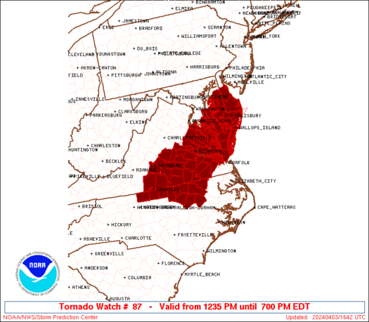
Severe T-storm Watch issued until 1AM off to our west.
SEVERE THUNDERSTORM WATCH OUTLINE UPDATE FOR WS 87
NWS STORM PREDICTION CENTER NORMAN OK
745 PM CDT TUE APR 12 2016
SEVERE THUNDERSTORM WATCH 87 IS IN EFFECT UNTIL 100 AM CDT
FOR THE FOLLOWING LOCATIONS
TXC013-019-025-029-031-055-091-123-127-137-163-171-175-177-187-
209-255-259-265-271-283-285-297-311-323-325-385-463-469-493-507-
130600-
/O.NEW.KWNS.SV.A.0087.160413T0045Z-160413T0600Z/
TX
. TEXAS COUNTIES INCLUDED ARE
ATASCOSA BANDERA BEE
BEXAR BLANCO CALDWELL
COMAL DEWITT DIMMIT
EDWARDS FRIO GILLESPIE
GOLIAD GONZALES GUADALUPE
HAYS KARNES KENDALL
KERR KINNEY LAVACA
LA SALLE LIVE OAK MAVERICK
MCMULLEN MEDINA REAL
UVALDE VICTORIA WILSON
ZAVALA
~~~When Thunder Roars Go Indoors~~~
~~~Turn Around Don't Drown~~~
~~~Run From The Water, Hide From The Wind~~~
~~~Turn Around Don't Drown~~~
~~~Run From The Water, Hide From The Wind~~~
Keeping a close eye on the storms out west. Numerous reports of Baseball and Tennis Ball sized hail doing damage in and around the San Antonio area as they move east. As these storms moved east they are expected to become more linear segments and hopefully the large hail threat will diminish some, but they still could pack a punch so stay weather aware. Also the heavy rain threat overnight continues into Wednesday morning. Target area for the heaviest rain continues to be primarily IH-10 and south towards the coast, but everyone can expect some rainfall from this system overnight.
~~~When Thunder Roars Go Indoors~~~
~~~Turn Around Don't Drown~~~
~~~Run From The Water, Hide From The Wind~~~
~~~Turn Around Don't Drown~~~
~~~Run From The Water, Hide From The Wind~~~
SPECIAL WEATHER STATEMENT
NATIONAL WEATHER SERVICE AUSTIN/SAN ANTONIO TX
1020 PM CDT TUE APR 12 2016
TXZ191>193-206>209-223-130415-
GUADALUPE TX-COMAL TX-FAYETTE TX-BASTROP TX-GONZALES TX-CALDWELL TX-
TRAVIS TX-HAYS TX-
1020 PM CDT TUE APR 12 2016
...SIGNIFICANT WEATHER ADVISORY FOR WEST CENTRAL FAYETTE...BASTROP...
CALDWELL...EAST CENTRAL COMAL...SOUTHERN TRAVIS...NORTHERN
GONZALES...NORTHEASTERN GUADALUPE AND CENTRAL HAYS COUNTIES UNTIL
1115 PM CDT...
AT 1020 PM CDT...DOPPLER RADAR WAS TRACKING A LINE OF STRONG
THUNDERSTORMS ALONG A LINE EXTENDING FROM NEAR BARTON CREEK TO NEAR
SAN MARCOS TO NEAR MCQUEENEY...AND MOVING SOUTHEAST AT 40 MPH.
DIME SIZE HAIL AND WIND GUSTS UP TO 50 MPH WILL BE POSSIBLE WITH
THESE STORMS.
LOCATIONS IMPACTED INCLUDE...
AUSTIN...NEW BRAUNFELS...SAN MARCOS...LOCKHART...GONZALES...BASTROP...
LULING...SMITHVILLE...WIMBERLEY...TANGLEWOOD FOREST...AUSTIN BERGSTROM
INT AP...KYLE...BUDA...ROLLINGWOOD...MARTINDALE...WAELDER...UHLAND...MUSTANG
RIDGE...NIEDERWALD AND BEAR CREEK.
PRECAUTIONARY/PREPAREDNESS ACTIONS...
TORRENTIAL RAINFALL IS ALSO OCCURRING WITH THESE STORMS...AND MAY
LEAD TO FLASH FLOODING. DO NOT DRIVE YOUR VEHICLE THROUGH FLOODED
ROADWAYS.
FREQUENT CLOUD TO GROUND LIGHTNING IS OCCURRING WITH THESE STORMS.
LIGHTNING CAN STRIKE 10 MILES AWAY FROM A THUNDERSTORM. SEEK A SAFE
SHELTER INSIDE A BUILDING OR VEHICLE.
THESE STORMS MAY INTENSIFY...SO BE CERTAIN TO MONITOR LOCAL RADIO AND
TV STATIONS...AS WELL AS LOCAL CABLE TV OUTLETS...FOR ADDITIONAL
INFORMATION AND POSSIBLE WARNINGS FROM THE NATIONAL WEATHER SERVICE.
&&
A SEVERE THUNDERSTORM WATCH REMAINS IN EFFECT UNTIL 100 AM CDT FOR
SOUTH CENTRAL TEXAS.
LAT...LON 3023 9709 2937 9731 2968 9810 3028 9801
TIME...MOT...LOC 0320Z 295DEG 35KT 3025 9789 2985 9790 2966 9806
$$
CP
SPECIAL WEATHER STATEMENT
NATIONAL WEATHER SERVICE AUSTIN/SAN ANTONIO TX
954 PM CDT TUE APR 12 2016
TXZ202-203-130330-
KINNEY TX-UVALDE TX-
954 PM CDT TUE APR 12 2016
...SIGNIFICANT WEATHER ADVISORY FOR WESTERN UVALDE AND EAST CENTRAL
KINNEY COUNTIES UNTIL 1030 PM CDT...
AT 954 PM CDT...DOPPLER RADAR WAS TRACKING A STRONG THUNDERSTORM NEAR
CLINE...OR 18 MILES EAST OF SPOFFORD...MOVING NORTHEAST AT 30 MPH.
DIME SIZE HAIL AND WINDS IN EXCESS OF 30 MPH WILL BE POSSIBLE WITH
THIS STORM.
LOCATIONS IMPACTED INCLUDE...
UVALDE...BLEWETT...LAGUNA...DABNEY...MONTELL...CLINE...UVALDE ESTATES AND
KNIPPA.
PRECAUTIONARY/PREPAREDNESS ACTIONS...
TORRENTIAL RAINFALL IS ALSO OCCURRING WITH THIS STORM...AND MAY LEAD
TO FLASH FLOODING. DO NOT DRIVE YOUR VEHICLE THROUGH FLOODED
ROADWAYS.
FREQUENT CLOUD TO GROUND LIGHTNING IS OCCURRING WITH THIS STORM.
LIGHTNING CAN STRIKE 10 MILES AWAY FROM A THUNDERSTORM. SEEK A SAFE
SHELTER INSIDE A BUILDING OR VEHICLE.
THIS STORM MAY INTENSIFY...SO BE CERTAIN TO MONITOR LOCAL RADIO AND
TV STATIONS...AS WELL AS LOCAL CABLE TV OUTLETS...FOR ADDITIONAL
INFORMATION AND POSSIBLE WARNINGS FROM THE NATIONAL WEATHER SERVICE.
&&
A SEVERE THUNDERSTORM WATCH REMAINS IN EFFECT UNTIL 100 AM CDT FOR
SOUTH CENTRAL TEXAS.
NATIONAL WEATHER SERVICE AUSTIN/SAN ANTONIO TX
1020 PM CDT TUE APR 12 2016
TXZ191>193-206>209-223-130415-
GUADALUPE TX-COMAL TX-FAYETTE TX-BASTROP TX-GONZALES TX-CALDWELL TX-
TRAVIS TX-HAYS TX-
1020 PM CDT TUE APR 12 2016
...SIGNIFICANT WEATHER ADVISORY FOR WEST CENTRAL FAYETTE...BASTROP...
CALDWELL...EAST CENTRAL COMAL...SOUTHERN TRAVIS...NORTHERN
GONZALES...NORTHEASTERN GUADALUPE AND CENTRAL HAYS COUNTIES UNTIL
1115 PM CDT...
AT 1020 PM CDT...DOPPLER RADAR WAS TRACKING A LINE OF STRONG
THUNDERSTORMS ALONG A LINE EXTENDING FROM NEAR BARTON CREEK TO NEAR
SAN MARCOS TO NEAR MCQUEENEY...AND MOVING SOUTHEAST AT 40 MPH.
DIME SIZE HAIL AND WIND GUSTS UP TO 50 MPH WILL BE POSSIBLE WITH
THESE STORMS.
LOCATIONS IMPACTED INCLUDE...
AUSTIN...NEW BRAUNFELS...SAN MARCOS...LOCKHART...GONZALES...BASTROP...
LULING...SMITHVILLE...WIMBERLEY...TANGLEWOOD FOREST...AUSTIN BERGSTROM
INT AP...KYLE...BUDA...ROLLINGWOOD...MARTINDALE...WAELDER...UHLAND...MUSTANG
RIDGE...NIEDERWALD AND BEAR CREEK.
PRECAUTIONARY/PREPAREDNESS ACTIONS...
TORRENTIAL RAINFALL IS ALSO OCCURRING WITH THESE STORMS...AND MAY
LEAD TO FLASH FLOODING. DO NOT DRIVE YOUR VEHICLE THROUGH FLOODED
ROADWAYS.
FREQUENT CLOUD TO GROUND LIGHTNING IS OCCURRING WITH THESE STORMS.
LIGHTNING CAN STRIKE 10 MILES AWAY FROM A THUNDERSTORM. SEEK A SAFE
SHELTER INSIDE A BUILDING OR VEHICLE.
THESE STORMS MAY INTENSIFY...SO BE CERTAIN TO MONITOR LOCAL RADIO AND
TV STATIONS...AS WELL AS LOCAL CABLE TV OUTLETS...FOR ADDITIONAL
INFORMATION AND POSSIBLE WARNINGS FROM THE NATIONAL WEATHER SERVICE.
&&
A SEVERE THUNDERSTORM WATCH REMAINS IN EFFECT UNTIL 100 AM CDT FOR
SOUTH CENTRAL TEXAS.
LAT...LON 3023 9709 2937 9731 2968 9810 3028 9801
TIME...MOT...LOC 0320Z 295DEG 35KT 3025 9789 2985 9790 2966 9806
$$
CP
SPECIAL WEATHER STATEMENT
NATIONAL WEATHER SERVICE AUSTIN/SAN ANTONIO TX
954 PM CDT TUE APR 12 2016
TXZ202-203-130330-
KINNEY TX-UVALDE TX-
954 PM CDT TUE APR 12 2016
...SIGNIFICANT WEATHER ADVISORY FOR WESTERN UVALDE AND EAST CENTRAL
KINNEY COUNTIES UNTIL 1030 PM CDT...
AT 954 PM CDT...DOPPLER RADAR WAS TRACKING A STRONG THUNDERSTORM NEAR
CLINE...OR 18 MILES EAST OF SPOFFORD...MOVING NORTHEAST AT 30 MPH.
DIME SIZE HAIL AND WINDS IN EXCESS OF 30 MPH WILL BE POSSIBLE WITH
THIS STORM.
LOCATIONS IMPACTED INCLUDE...
UVALDE...BLEWETT...LAGUNA...DABNEY...MONTELL...CLINE...UVALDE ESTATES AND
KNIPPA.
PRECAUTIONARY/PREPAREDNESS ACTIONS...
TORRENTIAL RAINFALL IS ALSO OCCURRING WITH THIS STORM...AND MAY LEAD
TO FLASH FLOODING. DO NOT DRIVE YOUR VEHICLE THROUGH FLOODED
ROADWAYS.
FREQUENT CLOUD TO GROUND LIGHTNING IS OCCURRING WITH THIS STORM.
LIGHTNING CAN STRIKE 10 MILES AWAY FROM A THUNDERSTORM. SEEK A SAFE
SHELTER INSIDE A BUILDING OR VEHICLE.
THIS STORM MAY INTENSIFY...SO BE CERTAIN TO MONITOR LOCAL RADIO AND
TV STATIONS...AS WELL AS LOCAL CABLE TV OUTLETS...FOR ADDITIONAL
INFORMATION AND POSSIBLE WARNINGS FROM THE NATIONAL WEATHER SERVICE.
&&
A SEVERE THUNDERSTORM WATCH REMAINS IN EFFECT UNTIL 100 AM CDT FOR
SOUTH CENTRAL TEXAS.
~~~When Thunder Roars Go Indoors~~~
~~~Turn Around Don't Drown~~~
~~~Run From The Water, Hide From The Wind~~~
~~~Turn Around Don't Drown~~~
~~~Run From The Water, Hide From The Wind~~~
AREA FORECAST DISCUSSION
NATIONAL WEATHER SERVICE HOUSTON/GALVESTON TX
958 PM CDT TUE APR 12 2016
.DISCUSSION...
CURRENT FCST IS IN PRETTY GOOD SHAPE. SHOWERS/STORMS HAVE
DEVELOPED TO OUR WEST AND WILL BE MOVING THRU SE TX OVERNIGHT.
EXPECT COVERAGE TO EXPAND LOCALLY AS INCREASINGLY DIFFLUENT UPPER
FLOW ENCOUNTERS DEEP TROPICAL MOISTURE BEING TRANSPORTED INLAND.
LATEST GUIDANCE IS SUGGESTING TWO POSSIBLE AREAS TO KEEP AN EYE ON
OVERNIGHT. THE FIRST AREA WILL BE CLOSER TO THE COAST WHERE A
FRONTAL BOUNDARY IS HUNG UP. THE SECOND IS AN AREA SITUATED FROM
MAYBE CLL-LFK WHERE AN AREA OF H85 SPEED CONVERGENCE IS FCST TO
SET UP. REMAINS TO BE SEEN AS TO HOW THE MESOSCALE PLAYS OUT BUT
BOTH AREAS SEEM PLAUSIBLE. LOCALIZED HEAVY RAIN AND STRONG STORMS
LOOK TO REMAIN POSSIBLE. HIRES GUIDANCE SUGGESTS PRECIP MIGHT MOVE
OUT A LITTLE FASTER THAN WHAT`S CURRENTLY IN THE FCST. BUT RUN-
TO-RUN CONSISTENCY HASN`T BEEN ALL THAT GREAT...SO THERE`S CONSIDERABLE
UNCERTAINTY IN THAT REGARD. 47
&&
~~~When Thunder Roars Go Indoors~~~
~~~Turn Around Don't Drown~~~
~~~Run From The Water, Hide From The Wind~~~
~~~Turn Around Don't Drown~~~
~~~Run From The Water, Hide From The Wind~~~
BULLETIN - IMMEDIATE BROADCAST REQUESTED
SEVERE THUNDERSTORM WARNING
NATIONAL WEATHER SERVICE AUSTIN/SAN ANTONIO TX
1038 PM CDT TUE APR 12 2016
THE NATIONAL WEATHER SERVICE IN AUSTIN SAN ANTONIO HAS ISSUED A
* SEVERE THUNDERSTORM WARNING FOR...
NORTH CENTRAL DEWITT COUNTY IN SOUTH CENTRAL TEXAS...
GONZALES COUNTY IN SOUTH CENTRAL TEXAS...
SOUTHEASTERN GUADALUPE COUNTY IN SOUTH CENTRAL TEXAS...
NORTHEASTERN WILSON COUNTY IN SOUTH CENTRAL TEXAS...
* UNTIL 1130 PM CDT
* AT 1036 PM CDT...A SEVERE THUNDERSTORM WAS LOCATED 12 MILES
NORTHWEST OF NIXON...OR 12 MILES SOUTHEAST OF SEGUIN...MOVING EAST
AT 40 MPH.
HAZARD...GOLF BALL SIZE HAIL AND 60 MPH WIND GUSTS.
SOURCE...RADAR INDICATED.
IMPACT...PEOPLE AND ANIMALS OUTDOORS WILL BE INJURED. EXPECT HAIL
DAMAGE TO ROOFS...SIDING...WINDOWS...AND VEHICLES. EXPECT
WIND DAMAGE TO ROOFS...SIDING...AND TREES.
* LOCATIONS IMPACTED INCLUDE...
SEGUIN...GONZALES...CUERO...NIXON...SMILEY...CHEAPSIDE...HOCHHEIM...
PALMETO...WESTHOFF...WRIGHTSBORO...BELMONT...OAK FOREST...LITTLE NEW
YORK...SAMPLE...DREYER...DILWORTH...CONCRETE...MONTHALIA...OTTINE AND
COST.
PRECAUTIONARY/PREPAREDNESS ACTIONS...
FOR YOUR PROTECTION MOVE TO AN INTERIOR ROOM ON THE LOWEST FLOOR OF A
BUILDING.
LARGE HAIL AND DAMAGING WINDS AND CONTINUOUS CLOUD TO GROUND
LIGHTNING IS OCCURRING WITH THIS STORM. MOVE INDOORS IMMEDIATELY.
LIGHTNING IS ONE OF NATURES LEADING KILLERS. REMEMBER...IF YOU CAN
HEAR THUNDER...YOU ARE CLOSE ENOUGH TO BE STRUCK BY LIGHTNING.
TORRENTIAL RAINFALL IS OCCURRING WITH THIS STORM...AND MAY LEAD TO
FLASH FLOODING. DO NOT DRIVE YOUR VEHICLE THROUGH FLOODED ROADWAYS.
~~~When Thunder Roars Go Indoors~~~
~~~Turn Around Don't Drown~~~
~~~Run From The Water, Hide From The Wind~~~
~~~Turn Around Don't Drown~~~
~~~Run From The Water, Hide From The Wind~~~
THE NATIONAL WEATHER SERVICE IN AUSTIN SAN ANTONIO HAS ISSUED A
* URBAN AND SMALL STREAM FLOOD ADVISORY FOR...
TRAVIS COUNTY IN SOUTH CENTRAL TEXAS...
WILLIAMSON COUNTY IN SOUTH CENTRAL TEXAS...
* UNTIL 145 AM CDT
* AT 1045 PM CDT...DOPPLER RADAR INDICATED HEAVY RAIN DUE TO
THUNDERSTORMS. THIS WILL CAUSE URBAN AND SMALL STREAM FLOODING IN
THE ADVISORY AREA. UP TO ONE INCH OF RAIN HAS ALREADY FALLEN.
* SOME LOCATIONS THAT WILL EXPERIENCE FLOODING INCLUDE...
AUSTIN...ROUND ROCK...CEDAR PARK...GEORGETOWN...PFLUGERVILLE...TAYLOR...
ELGIN...GRANGER...SERENADA...WINDEMERE...AUSTIN BERGSTROM INT AP...
TANGLEWOOD FOREST...ANDERSON MILL...LEANDER...HUTTO...MANOR...BEE CAVE...
WEST LAKE HILLS...ROLLINGWOOD AND LIBERTY HILL.
ADDITIONAL RAINFALL OF 1 TO 2 INCHES IS EXPECTED OVER THE AREA. THIS
ADDITIONAL RAIN WILL CAUSE MINOR FLOODING.
PRECAUTIONARY/PREPAREDNESS ACTIONS...
MOST FLOOD DEATHS OCCUR IN AUTOMOBILES. NEVER DRIVE YOUR VEHICLE INTO
AREAS WHERE THE WATER COVERS THE ROADWAY. FLOOD WATERS ARE USUALLY
DEEPER THAN THEY APPEAR. JUST ONE FOOT OF FLOWING WATER IS POWERFUL
ENOUGH TO SWEEP VEHICLES OFF THE ROAD. WHEN ENCOUNTERING FLOODED
ROADS MAKE THE SMART CHOICE...TURN AROUND...DONT DROWN.
~~~When Thunder Roars Go Indoors~~~
~~~Turn Around Don't Drown~~~
~~~Run From The Water, Hide From The Wind~~~
~~~Turn Around Don't Drown~~~
~~~Run From The Water, Hide From The Wind~~~
BULLETIN - IMMEDIATE BROADCAST REQUESTED
SEVERE THUNDERSTORM WARNING
NATIONAL WEATHER SERVICE AUSTIN/SAN ANTONIO TX
1057 PM CDT TUE APR 12 2016
THE NATIONAL WEATHER SERVICE IN AUSTIN SAN ANTONIO HAS ISSUED A
* SEVERE THUNDERSTORM WARNING FOR...
WESTERN FAYETTE COUNTY IN SOUTH CENTRAL TEXAS...
BASTROP COUNTY IN SOUTH CENTRAL TEXAS...
CALDWELL COUNTY IN SOUTH CENTRAL TEXAS...
SOUTHEASTERN TRAVIS COUNTY IN SOUTH CENTRAL TEXAS...
NORTHEASTERN GONZALES COUNTY IN SOUTH CENTRAL TEXAS...
SOUTH CENTRAL LEE COUNTY IN SOUTH CENTRAL TEXAS...
NORTHWESTERN LAVACA COUNTY IN SOUTH CENTRAL TEXAS...
* UNTIL MIDNIGHT CDT
* AT 1056 PM CDT...SEVERE THUNDERSTORMS WERE LOCATED ALONG A LINE
EXTENDING FROM NEAR AUSTIN BERGSTROM INT AP TO 12 MILES EAST OF
LOCKHART TO PALMETO...MOVING EAST AT 40 MPH.
HAZARD...60 MPH WIND GUSTS AND QUARTER SIZE HAIL.
SOURCE...RADAR INDICATED.
IMPACT...HAIL DAMAGE TO VEHICLES IS EXPECTED. EXPECT WIND DAMAGE
TO ROOFS...SIDING...AND TREES.
* LOCATIONS IMPACTED INCLUDE...
AUSTIN...LOCKHART...BASTROP...LULING...LA GRANGE...SMITHVILLE...
SCHULENBURG...HALLETTSVILLE...SHINER...FLATONIA...MOULTON...AUSTIN
BERGSTROM INT AP...WAELDER...MUSTANG RIDGE...ROSANKY...PAIGE...CEDAR
CREEK...MULDOON...CIRCLE D-KC ESTATE AND WYLDWOOD.
PRECAUTIONARY/PREPAREDNESS ACTIONS...
FOR YOUR PROTECTION MOVE TO AN INTERIOR ROOM ON THE LOWEST FLOOR OF A
BUILDING.
LARGE HAIL AND DAMAGING WINDS AND CONTINUOUS CLOUD TO GROUND
LIGHTNING IS OCCURRING WITH THESE STORMS. MOVE INDOORS IMMEDIATELY.
LIGHTNING IS ONE OF NATURES LEADING KILLERS. REMEMBER...IF YOU CAN
HEAR THUNDER...YOU ARE CLOSE ENOUGH TO BE STRUCK BY LIGHTNING.
TORRENTIAL RAINFALL IS OCCURRING WITH THESE STORMS...AND MAY LEAD TO
FLASH FLOODING. DO NOT DRIVE YOUR VEHICLE THROUGH FLOODED ROADWAYS.
~~~When Thunder Roars Go Indoors~~~
~~~Turn Around Don't Drown~~~
~~~Run From The Water, Hide From The Wind~~~
~~~Turn Around Don't Drown~~~
~~~Run From The Water, Hide From The Wind~~~
MESOSCALE DISCUSSION 0376
NWS STORM PREDICTION CENTER NORMAN OK
1106 PM CDT TUE APR 12 2016
AREAS AFFECTED...SCNTRL AND SE TX
CONCERNING...SEVERE POTENTIAL...WATCH LIKELY
VALID 130406Z - 130600Z
PROBABILITY OF WATCH ISSUANCE...80 PERCENT
SUMMARY...A SEVERE THREAT IS LIKELY TO CONTINUE...MOVING EWD FROM
SCNTRL TX INTO SE TX OVER THE NEXT FEW HOURS. WIND DAMAGE AND HAIL
WILL BE THE PRIMARY THREATS. WW ISSUANCE WILL LIKELY BE NEEDED
WITHIN THE HOUR.
DISCUSSION...LATEST SFC ANALYSIS SHOWS A QUASI-STATIONARY FRONT
LOCATED FROM SCNTRL TX EXTENDING ENEWD ACROSS SE TX. A
MULTI-SEGMENTED LINE WITH A BOWING STRUCTURE AND EMBEDDED SUPERCELL
IS LOCATED TO THE ENE OF SAN ANTONIO. THIS LINE WILL CONTINUE TO
MOVE EWD INTO SE TX OVER THE NEXT FEW HOURS...REMAINING PARALLEL TO
THE FRONT NEAR AND ON THE COOL SIDE OF THE BOUNDARY. ALTHOUGH
INSTABILITY IS WEAK IN THE HOUSTON AREA...THE LATEST HGX WSR-88D VWP
SHOWS 65 TO 70 KT OF 0-6 KM SHEAR WITH SUBSTANTIAL DIRECTIONAL SHEAR
FROM 0 TO 3 KM AGL. THIS WIND PROFILE WILL BE FAVORABLE FOR BOWING
LINE SEGMENTS WITH WIND DAMAGE AND POSSIBLY SUPERCELL STRUCTURES.
THE STRONG DEEP-LAYER SHEAR COMBINED WITH MODESTLY STEEP LAPSE RATES
MAY ALSO BE ENOUGH FOR HAIL WITH THE MORE INTENSE CORES.
~~~When Thunder Roars Go Indoors~~~
~~~Turn Around Don't Drown~~~
~~~Run From The Water, Hide From The Wind~~~
~~~Turn Around Don't Drown~~~
~~~Run From The Water, Hide From The Wind~~~

You are correct .... here it is until 5AM for parts of the area.mcheer23 wrote:Should be a Severe T-Storm watch issued within the hour.
SEVERE THUNDERSTORM WATCH OUTLINE UPDATE FOR WS 88
NWS STORM PREDICTION CENTER NORMAN OK
1125 PM CDT TUE APR 12 2016
SEVERE THUNDERSTORM WATCH 88 IS IN EFFECT UNTIL 500 AM CDT
FOR THE FOLLOWING LOCATIONS
TXC015-039-071-089-157-167-201-239-321-473-481-131000-
/O.NEW.KWNS.SV.A.0088.160413T0425Z-160413T1000Z/
TX
. TEXAS COUNTIES INCLUDED ARE
AUSTIN BRAZORIA CHAMBERS
COLORADO FORT BEND GALVESTON
HARRIS JACKSON MATAGORDA
WALLER WHARTON
$$
Last edited by djjordan on Tue Apr 12, 2016 11:43 pm, edited 1 time in total.
~~~When Thunder Roars Go Indoors~~~
~~~Turn Around Don't Drown~~~
~~~Run From The Water, Hide From The Wind~~~
~~~Turn Around Don't Drown~~~
~~~Run From The Water, Hide From The Wind~~~

NW Harris Co with a target on its back. Should be hit in about 2 hours. Huge meso that could affect from Navasota to League city. Lightning and thunder display beginning in CLLmcheer23 wrote:Should be a Severe T-Storm watch issued within the hour.
Last edited by DoctorMu on Wed Apr 13, 2016 1:27 am, edited 1 time in total.
BULLETIN - IMMEDIATE BROADCAST REQUESTED
SEVERE THUNDERSTORM WARNING
NATIONAL WEATHER SERVICE HOUSTON/GALVESTON TX
1142 PM CDT TUE APR 12 2016
THE NATIONAL WEATHER SERVICE IN LEAGUE CITY HAS ISSUED A
* SEVERE THUNDERSTORM WARNING FOR...
COLORADO COUNTY IN SOUTHEASTERN TEXAS...
WEST CENTRAL AUSTIN COUNTY IN SOUTHEASTERN TEXAS...
* UNTIL 1230 AM CDT
* AT 1141 PM CDT...SEVERE THUNDERSTORMS WERE LOCATED ALONG A LINE
EXTENDING FROM 8 MILES NORTHWEST OF LA GRANGE TO NEAR SCHULENBURG
TO 7 MILES SOUTHEAST OF MOULTON TO NEAR SHINER...MOVING EAST AT 45
MPH.
HAZARD...60 MPH WIND GUSTS AND HALF DOLLAR SIZE HAIL.
SOURCE...RADAR INDICATED.
IMPACT...HAIL DAMAGE TO VEHICLES IS EXPECTED. EXPECT WIND DAMAGE
TO ROOFS...SIDING...AND TREES.
* LOCATIONS IMPACTED INCLUDE...
COLUMBUS...EAGLE LAKE...WEIMAR...FRELSBURG...SHERIDAN...ROCK ISLAND...
ALTAIR...GARWOOD...CAT SPRING...NEW ULM AND NADA.
PRECAUTIONARY/PREPAREDNESS ACTIONS...
FOR YOUR PROTECTION MOVE TO AN INTERIOR ROOM ON THE LOWEST FLOOR OF A
BUILDING.
~~~When Thunder Roars Go Indoors~~~
~~~Turn Around Don't Drown~~~
~~~Run From The Water, Hide From The Wind~~~
~~~Turn Around Don't Drown~~~
~~~Run From The Water, Hide From The Wind~~~
SEVERE THUNDERSTORM WARNING
TXC021-149-177-285-287-130530-
/O.NEW.KEWX.SV.W.0072.160413T0445Z-160413T0530Z/
BULLETIN - IMMEDIATE BROADCAST REQUESTED
SEVERE THUNDERSTORM WARNING
NATIONAL WEATHER SERVICE AUSTIN/SAN ANTONIO TX
1145 PM CDT TUE APR 12 2016
THE NATIONAL WEATHER SERVICE IN AUSTIN SAN ANTONIO HAS ISSUED A
* SEVERE THUNDERSTORM WARNING FOR...
FAYETTE COUNTY IN SOUTH CENTRAL TEXAS...
EASTERN BASTROP COUNTY IN SOUTH CENTRAL TEXAS...
EAST CENTRAL GONZALES COUNTY IN SOUTH CENTRAL TEXAS...
LEE COUNTY IN SOUTH CENTRAL TEXAS...
NORTHERN LAVACA COUNTY IN SOUTH CENTRAL TEXAS...
* UNTIL 1230 AM CDT
* AT 1145 PM CDT...SEVERE THUNDERSTORMS WERE LOCATED ALONG A LINE
EXTENDING FROM 7 MILES NORTH OF CAMP SWIFT TO 8 MILES EAST OF
SMITHVILLE TO NEAR MULDOON TO 6 MILES NORTHWEST OF SCHULENBURG TO
NEAR SHINER...MOVING EAST AT 65 MPH.
HAZARD...70 MPH WIND GUSTS AND QUARTER SIZE HAIL.
SOURCE...RADAR INDICATED.
IMPACT...HAIL DAMAGE TO VEHICLES IS EXPECTED. EXPECT CONSIDERABLE
TREE DAMAGE. WIND DAMAGE IS ALSO LIKELY TO MOBILE HOMES...
ROOFS...AND OUTBUILDINGS.
* LOCATIONS IMPACTED INCLUDE...
BASTROP...GIDDINGS...LA GRANGE...SMITHVILLE...SCHULENBURG...FLATONIA...
LEXINGTON...MOULTON...SHELBY...FAYETTEVILLE...ROUND TOP...SUBLIME...
FEDOR...PAIGE...MULDOON...CIRCLE D-KC ESTATE...CIRCLE D-KC ESTATES...
CAMP SWIFT...DIME BOX AND UPTON.
PRECAUTIONARY/PREPAREDNESS ACTIONS...
FOR YOUR PROTECTION MOVE TO AN INTERIOR ROOM ON THE LOWEST FLOOR OF A
BUILDING.
LARGE HAIL AND DAMAGING WINDS AND CONTINUOUS CLOUD TO GROUND
LIGHTNING IS OCCURRING WITH THESE STORMS. MOVE INDOORS IMMEDIATELY.
LIGHTNING IS ONE OF NATURES LEADING KILLERS. REMEMBER...IF YOU CAN
HEAR THUNDER...YOU ARE CLOSE ENOUGH TO BE STRUCK BY LIGHTNING.
TORRENTIAL RAINFALL IS OCCURRING WITH THESE STORMS...AND MAY LEAD TO
FLASH FLOODING. DO NOT DRIVE YOUR VEHICLE THROUGH FLOODED ROADWAYS.
~~~When Thunder Roars Go Indoors~~~
~~~Turn Around Don't Drown~~~
~~~Run From The Water, Hide From The Wind~~~
~~~Turn Around Don't Drown~~~
~~~Run From The Water, Hide From The Wind~~~