
March 2016 - Progressive Changeable Weather To End The Month
Mark Sudduth
@hurricanetrack
S Mayde Creek yesterday vs just now. @JeffLindner1 @hcfcd
https://twitter.com/hurricanetrack/stat ... 6823359492
live flood cams http://hurricanetrack.com/flood/
@hurricanetrack
S Mayde Creek yesterday vs just now. @JeffLindner1 @hcfcd
https://twitter.com/hurricanetrack/stat ... 6823359492
live flood cams http://hurricanetrack.com/flood/
https://twitter.com/hcfcd/with_replies
* http://www.harriscountyfws.org/
* Adding: don't forget you can get "channel status" by changing the default of "rainfall" under "Map View Options" in upper left corner. You can also select "ALL" under "Gage Selection" to view all participating, outside Harris County
* http://www.harriscountyfws.org/
* Adding: don't forget you can get "channel status" by changing the default of "rainfall" under "Map View Options" in upper left corner. You can also select "ALL" under "Gage Selection" to view all participating, outside Harris County
Last edited by unome on Thu Mar 10, 2016 8:50 am, edited 1 time in total.
don't let your guard down, some areas still have rising water
https://twitter.com/HCOHSEM/with_replies
https://twitter.com/JeffLindner1/with_replies
https://twitter.com/HCOHSEM/with_replies
https://twitter.com/JeffLindner1/with_replies
Lake Conroe
http://www.lakeconroewebcams.com/
This monitor has elevation, rainfall and weather tabs
http://www.harriscountyfws.org/GageDetail/Index/2500
http://www.lakeconroewebcams.com/
This monitor has elevation, rainfall and weather tabs
http://www.harriscountyfws.org/GageDetail/Index/2500
-
srainhoutx

- Site Admin

- Posts: 19615
- Joined: Tue Feb 02, 2010 2:32 pm
- Location: Maggie Valley, NC
- Contact:
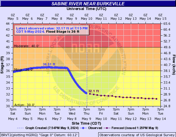
Just emptied 6.38 inches of rain from the rain gauge for the past 48 hours. Update from Jeff regarding Toledo Bend and the Sabine River:
Tremendous rainfall of 10-15 inches over the last 36 hours has resulted in a very large rise on Toledo Bend on the Sabine River.
A massive release of 207,000 cfs is currently underway at the dam with 9 flood gates opened 22 ft. In the last 2 hours the gates have been raised 5 ft to help stabilize the massive rise in progress on the lake.
Possible record flooding downstream along the Sabine River below Toledo Bend at Burkeville, TX with major to record flooding at Bon Weir and Deweyville.
Carla/Alicia/Jerry(In The Eye)/Michelle/Charley/Ivan/Dennis/Katrina/Rita/Wilma/Humberto/Ike/Harvey
Member: National Weather Association
Facebook.com/Weather Infinity
Twitter @WeatherInfinity
Member: National Weather Association
Facebook.com/Weather Infinity
Twitter @WeatherInfinity
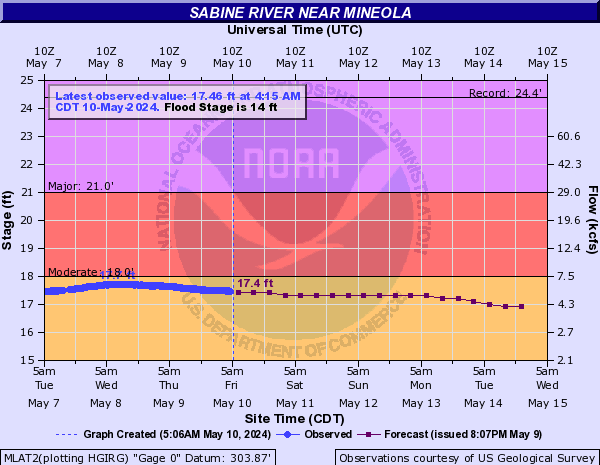
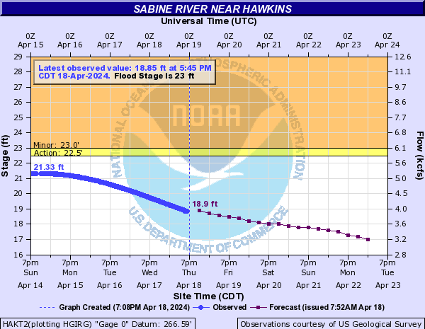
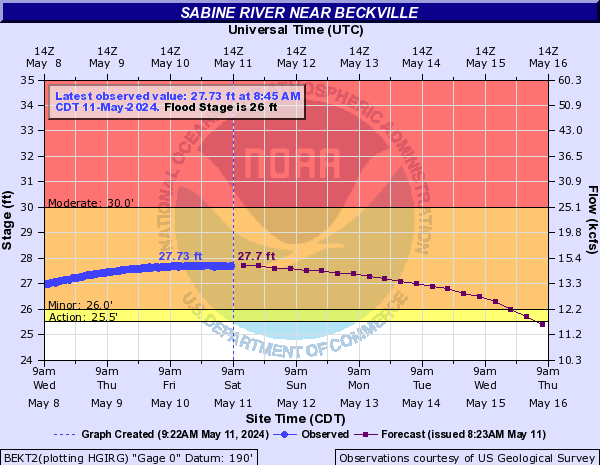
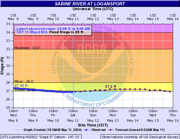
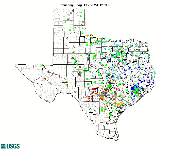
Sabine River at a glance http://www.texasriverdata.com/sabine.html

Texas at a glance http://waterdata.usgs.gov/tx/nwis/rt
Texas at a glance http://waterdata.usgs.gov/tx/nwis/rt
-
MontgomeryCoWx

- Posts: 2356
- Joined: Wed Dec 14, 2011 4:31 pm
- Location: Weimar, TX
- Contact:
I had 6.4 inches at my house in Magnolia.
Team #NeverSummer
-
srainhoutx
- Site Admin
- Posts: 19615
- Joined: Tue Feb 02, 2010 2:32 pm
- Location: Maggie Valley, NC
- Contact:
Update from Jeff regarding Toledo Bend/Sabine River:
This is a life threating flood situation for the Sabine River below Toledo Bend Reservoir.
Follow instructions from law enforcement and emergency management officials immediately.
Record release continues from Toledo Bend. Forecast flood wave to reach Burkeville, TX and surpass previous flood of record by 5.0 ft.
Potential record flooding at Deweyville, TX surpassing the previous record from 1884
- Attachments
-
Carla/Alicia/Jerry(In The Eye)/Michelle/Charley/Ivan/Dennis/Katrina/Rita/Wilma/Humberto/Ike/Harvey
Member: National Weather Association
Facebook.com/Weather Infinity
Twitter @WeatherInfinity
Member: National Weather Association
Facebook.com/Weather Infinity
Twitter @WeatherInfinity
-
srainhoutx
- Site Admin
- Posts: 19615
- Joined: Tue Feb 02, 2010 2:32 pm
- Location: Maggie Valley, NC
- Contact:
Jeff Update:
All-time record flood imminent on the lower Sabine River.
Mandatory evacuation order in effect for both the TX and LA side of the river downstream of Toledo Bend. This is a life threatening situation…follow emergency advice immediately.
Lake has reached 3rd highest pool (173.76ft) before massive release began at 600am. Latest data from the dam indicates the lake pool is rising again after a 1.5 ft fall as a result of the large releases this morning. The lake pool is not stabilized and additional gate increases are imminent to attempt to slow the pool rise and reduce pressure against the dam.
- Attachments
-
Carla/Alicia/Jerry(In The Eye)/Michelle/Charley/Ivan/Dennis/Katrina/Rita/Wilma/Humberto/Ike/Harvey
Member: National Weather Association
Facebook.com/Weather Infinity
Twitter @WeatherInfinity
Member: National Weather Association
Facebook.com/Weather Infinity
Twitter @WeatherInfinity
I wonder how Lewis Creek Reservoir dam is doing, since it's problems last May ? they have not received near the rainfall they did in 2015 http://www.harriscountyfws.org/GageDetail/Index/2640 (look back 1 yr)
http://www.entergynewsroom.com/latest-n ... at-public/
http://www.entergynewsroom.com/latest-n ... at-public/
USGS mobile water data site (beta) : http://m.waterdata.usgs.gov/
pan and zoom, very easy to use, especially for areas that span more than 1 state, such as the Sabine River
pan and zoom, very easy to use, especially for areas that span more than 1 state, such as the Sabine River
-
srainhoutx
- Site Admin
- Posts: 19615
- Joined: Tue Feb 02, 2010 2:32 pm
- Location: Maggie Valley, NC
- Contact:
Changed the Topic Title since the severe threat has stabilized. The powerful very deep upper low continues to spin SW of Monterrey, Nuevo Leon this morning. Fortunately we are getting a break with just light showers across the Houston area at this time, but obviously our neighbors in many locations across Metro Houston, The Piney Woods of East Texas and most of Louisiana are not doing too well at this time.

Carla/Alicia/Jerry(In The Eye)/Michelle/Charley/Ivan/Dennis/Katrina/Rita/Wilma/Humberto/Ike/Harvey
Member: National Weather Association
Facebook.com/Weather Infinity
Twitter @WeatherInfinity
Member: National Weather Association
Facebook.com/Weather Infinity
Twitter @WeatherInfinity
Looking forward to next week - Spring Break and the following weekend - what does the weather outlook look like?
-
srainhoutx
- Site Admin
- Posts: 19615
- Joined: Tue Feb 02, 2010 2:32 pm
- Location: Maggie Valley, NC
- Contact:
Update from Jeff:
Little Cypress Creek:
Creek is overbanks at Becker Rd with moderate flooding in progress. Subdivision on the south side of the creek west of Becker Rd is experiencing flooding of the streets as water backs up into the underground system. Water is close to some of the homes, but not in them. The creek is at crest and starting a very slow fall.
Spring Creek:
Creek is overbanks from the headwaters to below Hegar Rd. Field Store Rd and Hegar Rd have flooding over the roadways and are impassable. The creek is continuing a very slow rise at Hegar Rd. Downstream of SH 249, the creek is nearing bankfull at FM 2978 and and within 5-6 ft of bankfull at all points along the creek. Creek will continue a slow rise this afternoon, but should remain within banks.
South Mayde Creek:
Creek remains just overbanks at Greenhouse Rd. Creek has crested and is starting to fall. Greenhouse Rd is passable.
Upper Cypress Creek:
Creek is nearing bankfull at Sharp and Katy Hockley and will likely exceed banks later this morning. Current RFC forecast brings the creek to near 158.5 ft tomorrow morning. Minor flooding is likely along the channel from the headwaters to upstream of US 290. Portions of Sharp Rd and Katy Hockley will likely become inundated and possibly impassable later today or tonight. For areas downstream of US 290, the creek is high, but within banks and should crest within banks today.
Little Mound Creek:
Creek is overbanks and continuing a very slow rise. Mathis Rd is impacted and impassable at the bridge approaches. Creek is nearing crest and should begin to fall this afternoon.
No changes to the San Jacinto Basin forecasts.
Attached are a few photos from Little Cypress Creek.
2 Attachments
[/i]
Little Cypress Creek:
Creek is overbanks at Becker Rd with moderate flooding in progress. Subdivision on the south side of the creek west of Becker Rd is experiencing flooding of the streets as water backs up into the underground system. Water is close to some of the homes, but not in them. The creek is at crest and starting a very slow fall.
Spring Creek:
Creek is overbanks from the headwaters to below Hegar Rd. Field Store Rd and Hegar Rd have flooding over the roadways and are impassable. The creek is continuing a very slow rise at Hegar Rd. Downstream of SH 249, the creek is nearing bankfull at FM 2978 and and within 5-6 ft of bankfull at all points along the creek. Creek will continue a slow rise this afternoon, but should remain within banks.
South Mayde Creek:
Creek remains just overbanks at Greenhouse Rd. Creek has crested and is starting to fall. Greenhouse Rd is passable.
Upper Cypress Creek:
Creek is nearing bankfull at Sharp and Katy Hockley and will likely exceed banks later this morning. Current RFC forecast brings the creek to near 158.5 ft tomorrow morning. Minor flooding is likely along the channel from the headwaters to upstream of US 290. Portions of Sharp Rd and Katy Hockley will likely become inundated and possibly impassable later today or tonight. For areas downstream of US 290, the creek is high, but within banks and should crest within banks today.
Little Mound Creek:
Creek is overbanks and continuing a very slow rise. Mathis Rd is impacted and impassable at the bridge approaches. Creek is nearing crest and should begin to fall this afternoon.
No changes to the San Jacinto Basin forecasts.
Attached are a few photos from Little Cypress Creek.
2 Attachments
Carla/Alicia/Jerry(In The Eye)/Michelle/Charley/Ivan/Dennis/Katrina/Rita/Wilma/Humberto/Ike/Harvey
Member: National Weather Association
Facebook.com/Weather Infinity
Twitter @WeatherInfinity
Member: National Weather Association
Facebook.com/Weather Infinity
Twitter @WeatherInfinity
-
srainhoutx
- Site Admin
- Posts: 19615
- Joined: Tue Feb 02, 2010 2:32 pm
- Location: Maggie Valley, NC
- Contact:
ticka1 wrote:Looking forward to next week - Spring Break and the following weekend - what does the weather outlook look like?
Possibly a little more rain next Wednesday followed by near normal temperatures.
Carla/Alicia/Jerry(In The Eye)/Michelle/Charley/Ivan/Dennis/Katrina/Rita/Wilma/Humberto/Ike/Harvey
Member: National Weather Association
Facebook.com/Weather Infinity
Twitter @WeatherInfinity
Member: National Weather Association
Facebook.com/Weather Infinity
Twitter @WeatherInfinity

Just emptied 2.77" since yesterday am, on top of what I had the night before.

Morning guys. I see radar has quieted down quite a bit this morning. Will this be the case for the remainder of the day or will storms begin to fire up once again once heating gets established or are there any more complexes down south headed in our vicinity? I know rivers, creeks and bayous are the main focus now, but curious if we can expect any more heavy rains or has the main thorough finally shifted eastward? Thanks in advance.
Mike
Beaumont, TX
(IH-10 & College Street)
Beaumont, TX
(IH-10 & College Street)
-
srainhoutx
- Site Admin
- Posts: 19615
- Joined: Tue Feb 02, 2010 2:32 pm
- Location: Maggie Valley, NC
- Contact:
Long Public Information Statement from NWS HGX regarding rainfall amounts for the Houston/Galveston forecast area:
Code: Select all
PUBLIC INFORMATION STATEMENT
NATIONAL WEATHER SERVICE HOUSTON/GALVESTON TX
1005 AM CST THU MAR 10 2016
...PRELIMINARY RAINFALL REPORTS PAST 48 HOURS...
LOCATION AMOUNT TIME/DATE LAT/LON
...AUSTIN COUNTY...
SAN FELIPE 5.54 IN 0953 AM 03/10 29.80N/96.12W
SAN FELIPE 1.0 WNW 5.52 IN 0700 AM 03/10 29.80N/96.12W
BELLVILLE 0.4 NE 5.17 IN 0556 AM 03/10 29.95N/96.25W
1 SW BELLVILLE 4.85 IN 0925 AM 03/10 29.94N/96.27W
BELLVILLE 4.59 IN 0750 AM 03/10 30.02N/96.20W
BELLVILLE 6.5 NNE 4.53 IN 0700 AM 03/10 30.03N/96.22W
SEALY 1.9 NNE 4.46 IN 0700 AM 03/10 29.80N/96.14W
CAT SPRING 1.4 N 4.44 IN 0709 AM 03/10 29.87N/96.33W
NEW ULM 0.1 ENE 4.41 IN 0700 AM 03/10 29.89N/96.49W
MILL CREEK NEAR BELLVILLE 4.29 IN 0930 AM 03/10 29.88N/96.20W
1 NE WALLIS 3.89 IN 0800 AM 03/10 29.64N/96.05W
9 ENE FAYETTEVILLE 3.16 IN 0925 AM 03/10 29.98N/96.55W
7 NE EAGLE LAKE 3.14 IN 0925 AM 03/10 29.66N/96.24W
...BRAZORIA COUNTY...
OLD BRAZOS R 3.84 IN 0515 AM 03/10 28.95N/95.34W
9 SE NEEDVILLE 3.70 IN 0925 AM 03/10 29.30N/95.74W
LAKE JACKSON 1.3 SE 3.20 IN 0700 AM 03/10 29.03N/95.43W
LONGHERRIDGE 3.08 IN 0922 AM 03/10 29.55N/95.26W
6 SSE DANBURY 2.89 IN 0928 AM 03/10 29.15N/95.30W
COUNTRY CLUB DRIVE 2.88 IN 0446 AM 03/10 29.55N/95.25W
WEST COLUMBIA 1 ESE 2.83 IN 0800 AM 03/10 29.14N/95.63W
PEARLAND 4.4 W 2.77 IN 0700 AM 03/10 29.55N/95.35W
4 WNW WEST COLUMBIA 2.63 IN 0958 AM 03/10 29.18N/95.71W
1 S WEST COLUMBIA 2.56 IN 0959 AM 03/10 29.13N/95.65W
ALVIN 1.6 SW 2.55 IN 0800 AM 03/10 29.42N/95.27W
9 SW JONES CREEK 1.68 IN 0929 AM 03/10 28.86N/95.57W
2 ENE FRESNO 0.26 IN 0957 AM 03/10 29.55N/95.42W
...BRAZOS COUNTY...
COLLEGE STATION 1.6 S 3.65 IN 0700 AM 03/10 30.58N/96.31W
BRYAN 3.5 NNW 2.92 IN 0800 AM 03/10 30.71N/96.39W
...BURLESON COUNTY...
CALDWELL 5.11 IN 0958 AM 03/10 30.53N/96.71W
1 SSE SOMERVILLE 2.81 IN 0900 AM 03/10 30.32N/96.53W
4 NNW SOMERVILLE 1.85 IN 0955 AM 03/10 30.40N/96.55W
...CHAMBERS COUNTY...
MONT BELVIEU 1.5 NNW 4.98 IN 0800 AM 03/10 29.87N/94.89W
1 ENE ANAHUAC 4.84 IN 0700 AM 03/10 29.78N/94.66W
8 SSW STOWELL 3.44 IN 0912 AM 03/10 29.67N/94.44W
SPINDLETOP BAYOU @ STATE HIG 3.39 IN 0852 AM 03/10 29.75N/94.38W
3 SSW MONT BELVIEU 3.18 IN 0944 AM 03/10 29.80N/94.90W
1 WSW OLD RIVER-WINFREE 2.08 IN 0935 AM 03/10 29.87N/94.85W
NR CHARLOTTE 0.38 IN 0930 AM 03/10 29.87N/94.71W
...COLORADO COUNTY...
NEW ULM 7.2 S 4.52 IN 0700 AM 03/10 29.79N/96.48W
COLUMBUS 3.2 WSW 4.52 IN 0700 AM 03/10 29.68N/96.60W
7 E ELLINGER 4.34 IN 0925 AM 03/10 29.83N/96.58W
COLUMBUS 4.04 IN 0925 AM 03/10 29.71N/96.54W
5 W EAGLE LAKE 3.78 IN 0925 AM 03/10 29.58N/96.42W
GARWOOD 0.7 NW 3.52 IN 0800 AM 03/10 29.46N/96.40W
7 S WEIMAR 3.39 IN 0925 AM 03/10 29.60N/96.77W
6 NE EAGLE LAKE 3.27 IN 0935 AM 03/10 29.67N/96.27W
9 ESE FAYETTEVILLE 2.47 IN 0959 AM 03/10 29.85N/96.53W
4 E WEIMAR 1.94 IN 0956 AM 03/10 29.70N/96.71W
...FORT BEND COUNTY...
2 SE RICHMOND 8.76 IN 0951 AM 03/10 29.55N/95.73W
3 NE FULSHEAR 4.87 IN 0956 AM 03/10 29.74N/95.85W
SUGAR LAND .5 SE 4.76 IN 0730 AM 03/10 29.61N/95.63W
SUGARLAND 4.72 IN 0629 AM 03/10 29.64N/95.65W
SUGAR LAND 1.0 W 4.52 IN 0700 AM 03/10 29.62N/95.63W
RICHMOND 3.4 NE 4.44 IN 0600 AM 03/10 29.62N/95.73W
PECAN GROVE 4.19 IN 0700 AM 03/10 29.61N/95.73W
SUGAR LAND 3.8 SSW 4.15 IN 0700 AM 03/10 29.57N/95.64W
5 W MISSION BEND 4.07 IN 1000 AM 03/10 29.71N/95.75W
4 WSW FIRST COLONY 4.05 IN 0959 AM 03/10 29.54N/95.67W
1 ENE STAFFORD 3.96 IN 0956 AM 03/10 29.63N/95.54W
1 W STAFFORD 3.82 IN 0953 AM 03/10 29.62N/95.59W
2 SE RICHMOND 3.77 IN 0800 AM 03/10 29.56N/95.74W
STAFFORD 3.72 IN 0956 AM 03/10 29.61N/95.56W
WILLOW SPRING BAYOU 3.64 IN 0622 AM 03/10 29.65N/95.65W
2 WSW ARCOLA 3.56 IN 0830 AM 03/10 29.49N/95.51W
2 SW ROSENBERG 3.31 IN 0959 AM 03/10 29.52N/95.81W
3 SSE KATY 3.27 IN 0958 AM 03/10 29.76N/95.80W
1 SE MISSOURI CITY 3.24 IN 0952 AM 03/10 29.56N/95.52W
3 SE KATY 3.21 IN 0951 AM 03/10 29.76N/95.78W
4 ENE FULSHEAR 3.05 IN 0955 AM 03/10 29.71N/95.82W
RICHMOND 4.6 SE 3.05 IN 0604 AM 03/10 29.53N/95.72W
4 N PECAN GROVE 2.84 IN 0957 AM 03/10 29.69N/95.74W
2 S KATY 2.80 IN 0959 AM 03/10 29.76N/95.83W
RICHMOND 2.69 IN 0915 AM 03/10 29.58N/95.76W
2 NNW PECAN GROVE 2.16 IN 0947 AM 03/10 29.65N/95.75W
ROSENBERG 1.02 IN 0957 AM 03/10 29.55N/95.81W
5 SSE KATY 0.23 IN 0958 AM 03/10 29.73N/95.79W
...GALVESTON COUNTY...
GALVESTON 6.4 NE 5.23 IN 0700 AM 03/10 29.28N/94.80W
LEAGUE CITY 2.7 NE 3.87 IN 0800 AM 03/10 29.54N/95.07W
1 NNE LEAGUE CITY 3.86 IN 0954 AM 03/10 29.50N/95.10W
SANTA FE 2.5 NNW 3.84 IN 0700 AM 03/10 29.41N/95.12W
3 W LEAGUE CITY 3.64 IN 0929 AM 03/10 29.49N/95.15W
LEAGUE CITY 2.1 NE 3.46 IN 0800 AM 03/10 29.51N/95.09W
KEMAH 0.2 WNW 3.39 IN 0700 AM 03/10 29.53N/95.02W
LA MARQUE 3.9 SE 3.39 IN 0753 AM 03/10 29.33N/94.94W
LEAGUE CITY 3.6 ENE 3.37 IN 0800 AM 03/10 29.52N/95.04W
2 WSW SANTA FE 3.26 IN 1000 AM 03/10 29.36N/95.13W
BACLIFF 0.5 SSE 3.19 IN 0700 AM 03/10 29.50N/94.99W
1 W DICKINSON 2.96 IN 0700 AM 03/10 29.46N/95.09W
LA MARQUE 2.83 IN 0953 AM 03/10 29.36N/95.00W
1 WSW CLEAR LAKE SHORES 2.80 IN 0955 AM 03/10 29.54N/95.05W
CLEAR CREEK NEAR FREINDSWOOD 2.80 IN 0941 AM 03/10 29.52N/95.18W
1 W KEMAH 2.71 IN 0951 AM 03/10 29.53N/95.05W
FRIENDSWOOD 1.9 SSW 2.64 IN 0700 AM 03/10 29.49N/95.21W
2 WSW LEAGUE CITY 2.63 IN 0953 AM 03/10 29.47N/95.15W
FRIENDSWOOD 2.52 IN 0838 AM 03/10 29.54N/95.20W
2 ENE HILLCREST 2.23 IN 0958 AM 03/10 29.41N/95.18W
LA MARQUE LEVEE PUMP STATION 2.21 IN 0445 AM 03/10 29.35N/94.96W
2 NW SANTA FE 0.10 IN 0956 AM 03/10 29.41N/95.12W
18 E SAN LEON 0.04 IN 0950 AM 03/10 29.45N/94.64W
...GRIMES COUNTY...
STATE PARK 4.15 IN 0800 AM 03/10 30.33N/96.15W
8 SE NAVASOTA 2.05 IN 0958 AM 03/10 30.29N/96.00W
...HARRIS COUNTY...
9 NE KATY 7.28 IN 0700 AM 03/10 29.91N/95.73W
CYPRESS 3.2 ESE 5.81 IN 0700 AM 03/10 29.96N/95.65W
4 NNW JERSEY VILLAGE 5.64 IN 0956 AM 03/10 29.95N/95.60W
JERSEY VILLAGE 4.6 NW 5.31 IN 0700 AM 03/10 29.93N/95.63W
9 WNW JERSEY VILLAGE 5.24 IN 0959 AM 03/10 29.95N/95.71W
9 WNW JERSEY VILLAGE 5.24 IN 0957 AM 03/10 29.95N/95.71W
TOMBALL 2.7 ENE 5.20 IN 0600 AM 03/10 30.11N/95.57W
LITTLE MOUND CREEK AT BETKA 5.16 IN 0642 AM 03/10 30.02N/95.89W
SPRING CREEK AT TOMBALL 5.16 IN 0801 AM 03/10 30.06N/95.62W
5 S TOMBALL 5.09 IN 0958 AM 03/10 30.02N/95.61W
4 S TOMBALL 5.07 IN 0640 AM 03/10 30.03N/95.62W
GUM GULLY AT DIAMOND HEAD 5.00 IN 0500 AM 03/10 29.90N/95.08W
TRAILSIDE 4.84 IN 0637 AM 03/10 29.88N/95.63W
KINGWOOD 0.9 WNW 4.80 IN 0700 AM 03/10 30.07N/95.20W
KINGWOOD 4.76 IN 0943 AM 03/10 30.03N/95.20W
SPRING 10.0 WSW 4.61 IN 0800 AM 03/10 30.05N/95.58W
9 SW TOMBALL 4.53 IN 0947 AM 03/10 29.98N/95.71W
BEAR CREEK @ FM 529 4.44 IN 0636 AM 03/10 29.81N/95.70W
4 SE TOMBALL 4.42 IN 1000 AM 03/10 30.05N/95.58W
6 WSW JERSEY VILLAGE 4.40 IN 0958 AM 03/10 29.87N/95.67W
KINGWOOD 3.9 S 4.40 IN 0700 AM 03/10 30.00N/95.20W
KINGWOOD 1.8 E 4.38 IN 0700 AM 03/10 30.06N/95.16W
7 S TOMBALL 4.22 IN 0950 AM 03/10 29.99N/95.64W
7 N JERSEY VILLAGE 4.20 IN 0954 AM 03/10 29.99N/95.59W
CEDAR BAYOU SH 146 4.16 IN 0934 AM 03/10 29.77N/94.92W
BRAYS BAYOU AT ALIEF 4.07 IN 0636 AM 03/10 29.71N/95.59W
LA PORTE 1.3 W 3.84 IN 0700 AM 03/10 29.66N/95.07W
HOUSTON 6.2 W 3.81 IN 0730 AM 03/10 29.75N/95.49W
GARNERS BAYOU BELTWAY 8 3.77 IN 0643 AM 03/10 29.93N/95.23W
TAYLOR LAKE VILLAGE 4.1 WNW 3.71 IN 0700 AM 03/10 29.60N/95.12W
5 NNW MISSION BEND 3.70 IN 0700 AM 03/10 29.77N/95.71W
CARPENTERS BAYOU @ I-10 3.68 IN 0941 AM 03/10 29.77N/95.14W
4 E KINGWOOD 3.67 IN 0700 AM 03/10 30.07N/95.11W
KATY 5.0 ESE 3.66 IN 0600 AM 03/10 29.76N/95.75W
SATSUMA 3.64 IN 0642 AM 03/10 29.92N/95.58W
2 SW THE WOODLANDS 3.63 IN 0959 AM 03/10 30.13N/95.52W
SPRING 9.8 WNW 3.63 IN 0700 AM 03/10 30.13N/95.53W
FM 529 AND US 290 NR JERSEY 3.60 IN 0508 AM 03/10 29.88N/95.57W
MIDDLE BAYOU GENOA RED BLUFF 3.52 IN 0917 AM 03/10 29.65N/95.13W
WEBSTER 0.4 NW 3.49 IN 0700 AM 03/10 29.54N/95.12W
3 WSW SPRING 3.46 IN 0955 AM 03/10 30.05N/95.44W
MEYERLAND 3.44 IN 0923 AM 03/10 29.66N/95.46W
SOUTH HOUSTON 4.0 SSW 3.40 IN 0700 AM 03/10 29.61N/95.26W
GARNERS BAYOU @ RANKIN ROAD 3.39 IN 0641 AM 03/10 29.98N/95.28W
BUNKER HILL VILLAGE 3.6 NNW 3.38 IN 0600 AM 03/10 29.81N/95.55W
6 NNE JERSEY VILLAGE 3.37 IN 0954 AM 03/10 29.98N/95.53W
7 S TOMBALL 3.36 IN 0835 AM 03/10 29.99N/95.62W
WHITE OAK BAYOU AT LAKEVIEW 3.36 IN 0448 AM 03/10 29.89N/95.56W
3 WNW CROSBY 3.33 IN 0851 AM 03/10 29.95N/95.11W
WEBSTER 3.33 IN 0952 AM 03/10 29.54N/95.11W
CLEAR CREEK AT MYKAWA STREET 3.32 IN 0614 AM 03/10 29.60N/95.30W
4 WSW THE WOODLANDS 3.26 IN 0454 AM 03/10 30.13N/95.55W
TAYLOR LAKE @ NASA ROAD 1 3.24 IN 0748 AM 03/10 29.57N/95.05W
4 SE KATY 3.22 IN 0512 AM 03/10 29.76N/95.77W
2 NNW MISSION BEND 3.22 IN 0952 AM 03/10 29.73N/95.68W
CARPENTERS BAYOU AT WALLISVI 3.20 IN 0929 AM 03/10 29.79N/95.14W
TAYLOR LAKE VILLAGE 3.20 IN 0949 AM 03/10 29.56N/95.05W
CYPRESS CREEK @ CYPRESSWOOD 3.16 IN 0427 AM 03/10 30.03N/95.33W
1 NNW WEBSTER 3.16 IN 0700 AM 03/10 29.55N/95.13W
HEDWIG VILLAGE 1.1 NNW 3.15 IN 0700 AM 03/10 29.79N/95.53W
BRAYS BAYOU @ LAWNDALE 3.12 IN 0807 AM 03/10 29.72N/95.30W
1 NNW WEST UNIVERSITY PLACE 3.08 IN 0947 AM 03/10 29.74N/95.45W
CLEAR LAKE CITY 1.0 NNE 3.08 IN 0600 AM 03/10 29.58N/95.14W
CLOVERLEAF 1.7 W 3.05 IN 0600 AM 03/10 29.79N/95.20W
PASADENA 4.4 WNW 3.05 IN 0700 AM 03/10 29.68N/95.22W
BERRY B FOREST OAKS 3.04 IN 0638 AM 03/10 29.68N/95.24W
PASADENA 2.8 SW 3.04 IN 0700 AM 03/10 29.63N/95.19W
3 NW WEBSTER 3.02 IN 0952 AM 03/10 29.57N/95.15W
7 WSW SPRING 2.97 IN 0958 AM 03/10 30.01N/95.50W
7 WSW JERSEY VILLAGE 2.95 IN 0953 AM 03/10 29.84N/95.68W
WEST UNIVERSITY PLACE 0.4 WN 2.95 IN 0700 AM 03/10 29.72N/95.44W
5 W JERSEY VILLAGE 2.94 IN 0959 AM 03/10 29.90N/95.67W
6 W SPRING 2.93 IN 0957 AM 03/10 30.05N/95.49W
GREENS BAYOU @ BAMMEL N. HOU 2.92 IN 0505 AM 03/10 29.95N/95.48W
2 NNE FRIENDSWOOD 2.91 IN 0946 AM 03/10 29.55N/95.18W
7 WSW SPRING 2.90 IN 0957 AM 03/10 30.02N/95.50W
HUMBLE 2.89 IN 0947 AM 03/10 30.00N/95.26W
FRIENDSWOOD 1.6 NE 2.88 IN 0700 AM 03/10 29.53N/95.18W
ROSSLYN 2.88 IN 0917 AM 03/10 29.85N/95.46W
WESTBURY 2.86 IN 0700 AM 03/10 29.68N/95.47W
SPRING VALLEY 2.7 NW 2.85 IN 0800 AM 03/10 29.81N/95.54W
3 E JERSEY VILLAGE 2.77 IN 0959 AM 03/10 29.89N/95.51W
FRIENDSWOOD 1.4 NNE 2.76 IN 0700 AM 03/10 29.53N/95.19W
2 SW WEBSTER 2.73 IN 0958 AM 03/10 29.51N/95.14W
BUFFALO BAYOU AT TURNING BAS 2.72 IN 0616 AM 03/10 29.75N/95.29W
5 NW SHELDON 2.66 IN 0950 AM 03/10 29.93N/95.19W
BRAYS BAYOU GESSNER DR 2.64 IN 0634 AM 03/10 29.67N/95.53W
2 E KINGWOOD 2.62 IN 0946 AM 03/10 30.06N/95.15W
3 E WEST UNIVERSITY PLACE 2.62 IN 0700 AM 03/10 29.72N/95.37W
GREENS BAYOU AT BELTWAY 8 2.60 IN 0633 AM 03/10 29.94N/95.35W
3 WNW TAYLOR LAKE VILLAGE 2.44 IN 0959 AM 03/10 29.60N/95.11W
HOUSTON 1.4 NE 2.38 IN 0700 AM 03/10 29.79N/95.37W
HOUSTON 2.1 NNE 2.38 IN 0700 AM 03/10 29.80N/95.37W
WHITE OAK BAYOU 2.37 IN 0758 AM 03/10 29.80N/95.45W
6 NW MISSION BEND 2.34 IN 0945 AM 03/10 29.76N/95.73W
2 S HOUSTON 2.31 IN 0952 AM 03/10 29.74N/95.39W
HOUSTON 2.28 IN 0938 AM 03/10 29.73N/95.37W
1 NNE HOUSTON 2.27 IN 0916 AM 03/10 29.79N/95.38W
3 W BELLAIRE 2.26 IN 0959 AM 03/10 29.69N/95.52W
1 NE HOUSTON 2.26 IN 0952 AM 03/10 29.78N/95.37W
4 WNW JERSEY VILLAGE 2.22 IN 1000 AM 03/10 29.91N/95.63W
PINEY POINT VILLAGE 2.22 IN 0958 AM 03/10 29.77N/95.51W
3 NNW NASSAU BAY 2.12 IN 0951 AM 03/10 29.59N/95.11W
PEARLAND 2.12 IN 0941 AM 03/10 29.63N/95.39W
WEBSTER 2.10 IN 0956 AM 03/10 29.54N/95.10W
2 WNW BUNKER HILL VILLAGE 2.00 IN 0954 AM 03/10 29.78N/95.57W
3 W SPRING 1.98 IN 0955 AM 03/10 30.05N/95.44W
1 WNW SPRING 1.97 IN 0958 AM 03/10 30.07N/95.41W
3 ENE PEARLAND 1.74 IN 0945 AM 03/10 29.58N/95.23W
2 NE WEST UNIVERSITY PLACE 1.67 IN 0949 AM 03/10 29.74N/95.40W
2 WSW PASADENA 1.66 IN 0755 AM 03/10 29.65N/95.19W
1 SSW PINEY POINT VILLAGE 1.58 IN 0958 AM 03/10 29.75N/95.52W
...HOUSTON COUNTY...
CROCKETT 1.8 NNE 3.56 IN 0700 AM 03/10 31.34N/95.45W
...JACKSON COUNTY...
EDNA 7 NW 3.52 IN 0700 AM 03/10 29.06N/96.76W
GANADO 3.00 IN 0958 AM 03/10 29.04N/96.51W
9 W LA WARD 2.44 IN 0958 AM 03/10 28.82N/96.62W
6 WSW LA WARD 2.42 IN 0958 AM 03/10 28.79N/96.55W
EDNA 2.39 IN 0955 AM 03/10 28.98N/96.65W
LA WARD 1.82 IN 0957 AM 03/10 28.84N/96.46W
7 S GANADO 1.53 IN 0958 AM 03/10 28.94N/96.52W
5 S LA WARD 1.20 IN 0957 AM 03/10 28.77N/96.46W
8 SSE LA WARD 1.07 IN 0958 AM 03/10 28.73N/96.42W
6 WNW LA WARD 0.56 IN 0958 AM 03/10 28.89N/96.56W
...LIBERTY COUNTY...
SITE 1 6.70 IN 0700 AM 03/10 30.36N/95.09W
3 S CLEVELAND 5.84 IN 0700 AM 03/10 30.29N/95.08W
3 NE SPLENDORA 5.81 IN 0955 AM 03/10 30.27N/95.13W
4 NW DAYTON 5.39 IN 0922 AM 03/10 30.11N/94.93W
EF SAN JACINTO RIVER 5.12 IN 0945 AM 03/10 30.34N/95.10W
CLEVELAND 0.9 SW 5.05 IN 0650 AM 03/10 30.33N/95.09W
TRINITY RIVER AT ROMAYER 4.59 IN 0931 AM 03/10 30.43N/94.85W
BATISTE CREEK @ S.H. 770 4.37 IN 0942 AM 03/10 30.16N/94.64W
LUCE BAYOU AT FM 2100 4.21 IN 0421 AM 03/10 30.05N/95.05W
...MADISON COUNTY...
MADISONVILLE 3.24 IN 0800 AM 03/10 30.95N/95.91W
...MARINE REPORTING STATIONS...
16 E PALACIOS 2.06 IN 0926 AM 03/10 28.68N/95.97W
...MATAGORDA COUNTY...
2 W BAY CITY 2.73 IN 0925 AM 03/10 28.97N/96.01W
9 W MARKHAM 1.84 IN 0925 AM 03/10 28.72N/95.99W
9 SW MARKHAM 1.82 IN 0745 AM 03/10 28.87N/96.17W
15 S SWEENY 1.72 IN 0926 AM 03/10 28.84N/95.66W
...MONTGOMERY COUNTY...
NEW WAVERLY 4 S 7.21 IN 0808 AM 03/10 30.49N/95.51W
2 W STAGECOACH 6.62 IN 0950 AM 03/10 30.15N/95.76W
PINEHURST 3.8 SE 6.53 IN 0722 AM 03/10 30.15N/95.66W
TOMBALL 1N 6.36 IN 0617 AM 03/10 30.12N/95.65W
THE WOODLANDS 5.8 NW 6.30 IN 0700 AM 03/10 30.21N/95.56W
MONTGOMERY 2.6 NE 6.29 IN 0700 AM 03/10 30.41N/95.66W
4 W WILLIS 6.22 IN 0924 AM 03/10 30.42N/95.55W
3 ENE PINEHURST 6.17 IN 0954 AM 03/10 30.22N/95.66W
LAKE CONROE NR CONROE 6.17 IN 0935 AM 03/10 30.36N/95.56W
WILLIS 6.16 IN 0749 AM 03/10 30.42N/95.49W
1 W CONROE 6.11 IN 0700 AM 03/10 30.32N/95.49W
LAKE CREEK AT HONEA-EGYPT RO 5.72 IN 0457 AM 03/10 30.25N/95.58W
FM 2978 5.68 IN 0803 AM 03/10 30.13N/95.60W
HUFSMITH 5.44 IN 0803 AM 03/10 30.17N/95.54W
4 NNW SHENANDOAH 5.42 IN 0903 AM 03/10 30.24N/95.48W
1 W CONROE 5.42 IN 0936 AM 03/10 30.32N/95.49W
2 E NEW CANEY 4.99 IN 0600 AM 03/10 30.13N/95.18W
WF SAN JACINTO 4.84 IN 0930 AM 03/10 30.24N/95.46W
CANEY CREEK AT SPLENDORA 4.64 IN 0748 AM 03/10 30.26N/95.30W
THE WOODLANDS 1.8 SE 4.48 IN 0700 AM 03/10 30.14N/95.47W
4 NW THE WOODLANDS 4.40 IN 0958 AM 03/10 30.21N/95.54W
THE WOODLANDS 1.4 WNW 4.36 IN 0700 AM 03/10 30.17N/95.51W
2 ENE MONTGOMERY 4.28 IN 0945 AM 03/10 30.41N/95.66W
3 NW TOMBALL 4.08 IN 0956 AM 03/10 30.13N/95.65W
OAK RIDGE NORTH 3.80 IN 0957 AM 03/10 30.17N/95.44W
4 ENE MONTGOMERY 3.80 IN 0957 AM 03/10 30.42N/95.63W
4 N TOMBALL 3.01 IN 0949 AM 03/10 30.16N/95.63W
UNION GROVE 3.01 IN 0625 AM 03/10 30.54N/95.75W
1 WNW THE WOODLANDS 2.56 IN 0958 AM 03/10 30.17N/95.51W
3 E SPRING 2.22 IN 0953 AM 03/10 30.07N/95.33W
2 NE SPRING 2.20 IN 0955 AM 03/10 30.09N/95.36W
THE WOODLANDS 2.8 N 2.17 IN 0700 AM 03/10 30.20N/95.50W
5 N CUT AND SHOOT 0.31 IN 0930 AM 03/10 30.42N/95.34W
...POLK COUNTY...
LONG KING CRK AT LIVINGSTON 7.55 IN 0930 AM 03/10 30.72N/94.96W
7 ENE SEVEN OAKS 6.71 IN 0948 AM 03/10 30.90N/94.75W
LIVINGSTON 8.4 W 6.66 IN 0800 AM 03/10 30.70N/95.08W
ONALASKA 6 NE 6.60 IN 0810 AM 03/10 30.85N/95.03W
LIVINGSTON 2.6 SSW 6.16 IN 0800 AM 03/10 30.67N/94.95W
LIVINGSTON 13.4 NW 6.04 IN 0700 AM 03/10 30.86N/95.08W
ONALASKA 0.6 WSW 5.97 IN 0700 AM 03/10 30.81N/95.12W
LIVINGSTON 0.5 E 5.91 IN 0800 AM 03/10 30.71N/94.93W
2 NNE LIVINGSTON 5.37 IN 0630 AM 03/10 30.74N/94.93W
1 NE ONALASKA 4.09 IN 0959 AM 03/10 30.83N/95.09W
...SAN JACINTO COUNTY...
WOLF CREEK PARK 5.60 IN 0807 AM 03/10 30.67N/95.15W
5 SSE COLDSPRING 5.45 IN 0902 AM 03/10 30.52N/95.09W
4 N COLDSPRING 4.96 IN 0953 AM 03/10 30.66N/95.12W
POINT BLANK 6 N 4.88 IN 0510 AM 03/10 30.82N/95.23W
4 ESE RIVERSIDE 4.54 IN 0957 AM 03/10 30.83N/95.33W
4 NNW COLDSPRING 4.11 IN 0956 AM 03/10 30.65N/95.15W
...TRINITY COUNTY...
TRINITY 10 E 5.41 IN 0836 AM 03/10 30.95N/95.20W
FRIDAY 4.68 IN 0509 AM 03/10 31.10N/95.20W
WHITE ROCK CREEK 4.20 IN 0923 AM 03/10 31.01N/95.37W
...WALKER COUNTY...
7 ESE HUNTSVILLE 8.76 IN 0959 AM 03/10 30.65N/95.44W
DODGE 1.6 S 6.55 IN 0800 AM 03/10 30.72N/95.40W
RIVERSIDE 2.0 WNW 6.00 IN 0800 AM 03/10 30.86N/95.43W
HUNTSVILLE 5.60 IN 0705 AM 03/10 30.71N/95.54W
HUNTSVILLE 3.6 NNW 5.08 IN 0700 AM 03/10 30.76N/95.58W
2 WNW HUNTSVILLE 4.83 IN 0906 AM 03/10 30.74N/95.59W
HUNTSVILLE 11.5 WSW 4.47 IN 0700 AM 03/10 30.63N/95.71W
SHIRO 6 NE 3.68 IN 0422 AM 03/10 30.66N/95.81W
...WALLER COUNTY...
6 W STAGECOACH 5.50 IN 0953 AM 03/10 30.13N/95.81W
6 SSW TODD MISSION 5.35 IN 0948 AM 03/10 30.17N/95.86W
HEMPSTEAD 4.92 IN 0942 AM 03/10 30.11N/96.08W
...WASHINGTON COUNTY...
HEMPSTEAD 10.0 NNW 4.93 IN 0700 AM 03/10 30.23N/96.14W
CHAPPELL HILL 1.8 N 4.72 IN 0700 AM 03/10 30.17N/96.25W
CHAPPELL HILL 1.0 NW 4.70 IN 0700 AM 03/10 30.16N/96.26W
6 WSW NAVASOTA 4.66 IN 0959 AM 03/10 30.34N/96.18W
BRENHAM 8.0 E 4.55 IN 0700 AM 03/10 30.16N/96.26W
8 WSW BRENHAM 4.35 IN 0640 AM 03/10 30.09N/96.51W
WASHINGTON 3.1 SSW 4.24 IN 0800 AM 03/10 30.28N/96.17W
BRAZOS RIVER AT HEMPSTEAD 3.94 IN 0915 AM 03/10 30.13N/96.19W
BRENHAM 1.4 NNW 3.90 IN 0603 AM 03/10 30.18N/96.40W
BRENHAM 3.86 IN 0700 AM 03/10 30.17N/96.40W
6 ESE BURTON 3.05 IN 0956 AM 03/10 30.13N/96.52W
CARMINE 3.1 WNW 2.92 IN 0700 AM 03/10 30.16N/96.74W
10 E BRENHAM 2.50 IN 0953 AM 03/10 30.19N/96.23W
...WHARTON COUNTY...
8 N GANADO 4.00 IN 0925 AM 03/10 29.16N/96.51W
1 NE EAST BERNARD 3.42 IN 0925 AM 03/10 29.53N/96.06W
7 N GANADO 3.00 IN 0958 AM 03/10 29.16N/96.53W
6 WNW WHARTON 2.87 IN 0925 AM 03/10 29.34N/96.20W
3 WSW KENDLETON 2.75 IN 0700 AM 03/10 29.42N/96.06W
EL CAMPO 2.5 WSW 2.75 IN 0700 AM 03/10 29.18N/96.32W
EL CAMPO 2.7 NW 2.52 IN 0800 AM 03/10 29.23N/96.30W
WHARTON 2.46 IN 0925 AM 03/10 29.31N/96.10W
EL CAMPO 1.0 NW 2.30 IN 0600 AM 03/10 29.21N/96.29W
WHARTON 3.1 NE 2.23 IN 0700 AM 03/10 29.35N/96.07W
2 NW EL CAMPO 2.06 IN 0925 AM 03/10 29.22N/96.29W
EL CAMPO 4.9 SSE 1.88 IN 0700 AM 03/10 29.13N/96.26W
9 WSW BOLING-IAGO 1.78 IN 0925 AM 03/10 29.19N/96.07W
WHARTON 0.3 E 1.75 IN 0700 AM 03/10 29.32N/96.09W
1 W DANEVANG 1.58 IN 0700 AM 03/10 29.05N/96.23W
OBSERVATIONS ARE COLLECTED FROM A VARIETY OF SOURCES WITH VARYING
EQUIPMENT AND EXPOSURE. NOT ALL DATA LISTED ARE CONSIDERED OFFICIAL.
$$
NWS HOUSTON/GALVESTON TX
IRIS SYSTEMCarla/Alicia/Jerry(In The Eye)/Michelle/Charley/Ivan/Dennis/Katrina/Rita/Wilma/Humberto/Ike/Harvey
Member: National Weather Association
Facebook.com/Weather Infinity
Twitter @WeatherInfinity
Member: National Weather Association
Facebook.com/Weather Infinity
Twitter @WeatherInfinity
-
srainhoutx
- Site Admin
- Posts: 19615
- Joined: Tue Feb 02, 2010 2:32 pm
- Location: Maggie Valley, NC
- Contact:
djmike wrote:Morning guys. I see radar has quieted down quite a bit this morning. Will this be the case for the remainder of the day or will storms begin to fire up once again once heating gets established or are there any more complexes down south headed in our vicinity? I know rivers, creeks and bayous are the main focus now, but curious if we can expect any more heavy rains or has the main thorough finally shifted eastward? Thanks in advance.
Judging by what I am seeing, the main threat has shifted E toward the Central and SE Louisiana area near New Orleans. That said as long as the upper low is to our SW, don't be surprised if some additional showers and storms blossom ahead of the upper low as it moves toward SE Texas tomorrow and finally shears out Saturday.
- Attachments
-
Carla/Alicia/Jerry(In The Eye)/Michelle/Charley/Ivan/Dennis/Katrina/Rita/Wilma/Humberto/Ike/Harvey
Member: National Weather Association
Facebook.com/Weather Infinity
Twitter @WeatherInfinity
Member: National Weather Association
Facebook.com/Weather Infinity
Twitter @WeatherInfinity