May Weather Discussion.

General Weather Discussions and Analysis
Post Reply
User avatar
srainhoutx
Site Admin
Site Admin
Posts: 19616
Joined: Tue Feb 02, 2010 2:32 pm
Location: Maggie Valley, NC
Contact:

Although our part of SE TX is not currently in the Slight Risk, we do have another High Risk event for areas in the Mid South. Another worrisome weekend for those folks.

Image
Image
Image

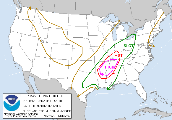
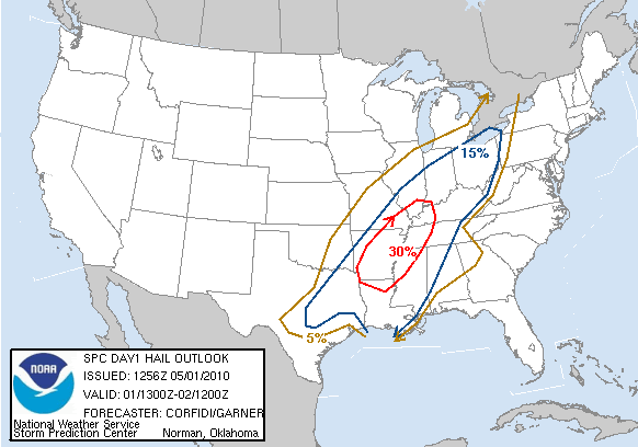
DAY 1 CONVECTIVE OUTLOOK
NWS STORM PREDICTION CENTER NORMAN OK
0756 AM CDT SAT MAY 01 2010

VALID 011300Z - 021200Z

...THERE IS A HIGH RISK OF SVR TSTMS OVER PARTS OF AR...MS...TN AND
THE MO BOOTHEEL...

...THERE IS A MDT RISK OF SVR TSTMS SURROUNDING THE HIGH RISK AREA
OVER PARTS OF THE LWR MS...LWR TN AND LWR OH VLYS...

...THERE IS A SLGT RISK OF SVR TSTMS SURROUNDING THE ABOVE AREAS
FROM E TX NEWD INTO THE UPR OH VLY...

...SYNOPSIS...
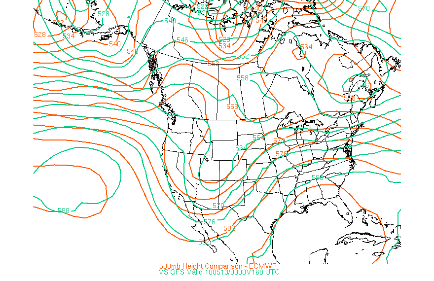
HIGH AMPLITUDE CNTRL STATES TROUGH WILL MOVE ONLY SLOWLY E THIS
PERIOD AS ASSOCIATED NRN PLAINS UPR LOW REMAINS QSTNRY AND ATTENDANT
SHORTWAVE TROUGH NOW ENTERING CHIHUAHUA SHEARS ENE ACROSS W
TX...OK...AND...BY SUN MORNING...KS/MO. MID/UPR LVL
SPEED MAX WITH THE CHIHUAHUA SYSTEM WILL REDEVELOP NE INTO N TX/OK
BY THIS EVE...AND FURTHER EXPAND NE ACROSS MID MS VLY/UPR GRT LKS
EARLY SUN.

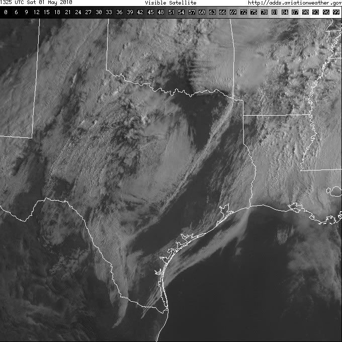
AT THE SFC...MAIN FRONTAL ZONE WILL REMAIN NEARLY STNRY FROM LWR MI
TO E TX TODAY...WITH COMPOSITE OUTFLOW BOUNDARY LEFT BY OVERNIGHT
STORMS LIKELY TO LIFT SLOWLY N ACROSS AR AND THE LWR TN VLY. A WAVE
SHOULD FORM OVER NE TX OR THE ARKLATEX LATER TODAY...NEAR
INTERSECTION OF OUTFLOW BOUNDARY WITH FRONT. THE WAVE SHOULD TRACK
NNE INTO THE LWR OH VLY TONIGHT/EARLY SUN.

...E TX/LWR MS VLY INTO THE LWR TN/LWR OH VLYS THROUGH TONIGHT...
WSW-ENE ORIENTED QLCS OVER THE LWR MS AND TN VLYS MAY FURTHER WEAKEN
LATER THIS MORNING AS WEAK HEIGHT RISES OVERSPREAD REGION AND SFC
TEMPERATURES REACH DIURNAL MINIMUMS. SFC HEATING AND CONTINUED
INFLOW OF VERY MOIST AIR SHOULD...HOWEVER...SUPPORT REDEVELOPMENT OF
SOME STORMS IN WHAT IS LEFT OF THE MCS BY EARLY AFTN...WITH
ADDITIONAL DEVELOPMENT POSSIBLE TO ITS S OVER SRN/CNTRL AR AND NRN
MS. OTHER STORMS MAY FORM LATER THIS MORNING AND THIS AFTN OVER NE
TX AND SE OK...AS ISENTROPIC ASCENT DOWNSTREAM FROM CHIHUAHUA UPR
IMPULSE INCREASES ATOP SHALLOW FRONT.

COMBINATION OF DAYTIME HEATING AND RICH MOISTURE /PW 1.50-1.75
INCHES WITH SFC DEWPOINTS IN THE LOW 70S/ SHOULD ALLOW FOR
SUBSTANTIAL LOW LVL DESTABILIZATION ALONG AND S OF MCS OUTFLOW
BOUNDARY AND E OF FRONT...WITH SBCAPE EXPECTED TO BE AOA 2000 J/KG
WITH MINIMAL CINH. COUPLED WITH STRONGLY-SHEARED LOW TO MID LVL
WIND FIELD...SETUP COULD SUPPORT SCTD SUSTAINED SUPERCELLS WITH
TORNADOES/SVR HAIL.

AS THE CHIHUAHUA SYSTEM AND ASSOCIATED MID/UPR LVL SPEED MAX /WITH
250 MB FLOW AROUND 150 KTS/ CONTINUE NEWD LATER THIS AFTN AND
TONIGHT...DOWNSTREAM SLY LLJ SHOULD MARKEDLY INCREASE OVER THE LWR
MS AN TN VLYS. THIS SHOULD SUPPORT ENHANCEMENT OF EXISTING
STORMS...AS WELL AS ADDITIONAL DEVELOPMENT...FROM THE ARKLATEX
E/NEWD INTO THE LWR TN AND LWR OH VLYS THROUGH THE
EVENING/OVERNIGHT.

60 KT DEEP SWLY SHEAR AND DEEPLY-MOIST ENVIRONMENT WITH NEARLY
UNIDIRECTIONAL MID/UPR LVL FLOW WILL BE FAVORABLE FOR SUPERCELL ECHO
TRAINING/LEWPS AS SFC WAVE TRACKS NE TOWARD THE OH VLY. THE SETUP
ULTIMATELY MAY SUPPORT MULTIPLE CORRIDORS HAVING A POTENTIAL FOR
STRONG TORNADOES FROM MUCH OF AR AND NRN MS NEWD INTO WRN/CNTRL
TN...WRN/CNTRL KY AND PERHAPS SRN IL/SRN INDIANA TONIGHT/EARLY SUN.

...MIDDLE/UPR OH VLY...
ERN END OF AFOREMENTIONED QLCS SHOULD CONTINUE E ACROSS ERN KY AND
CNTRL/ERN OH THROUGH LATER THIS MORNING. DIURNAL DESTABILIZATION
AND MODEST LOW LVL MOISTURE INFLOW MAY SUPPORT A MODEST SVR THREAT
/DMGG WINDS OR AN ISOLD TORNADO/ THROUGH EARLY EVE. ADDITIONAL
STRONG TO SVR ACTIVITY MAY AFFECT THE REGION LATE IN THE PERIOD
/AFTER 06Z SUN/ AS SFC WAVE MOVES NE TOWARD THE LWR OH VLY AND
ASSOCIATED LLJ STRENGTHENS OVER ERN KY/OH.

..CORFIDI/GARNER.. 05/01/2010
Carla/Alicia/Jerry(In The Eye)/Michelle/Charley/Ivan/Dennis/Katrina/Rita/Wilma/Humberto/Ike/Harvey

Member: National Weather Association
Facebook.com/Weather Infinity
Twitter @WeatherInfinity
User avatar
srainhoutx
Site Admin
Site Admin
Posts: 19616
Joined: Tue Feb 02, 2010 2:32 pm
Location: Maggie Valley, NC
Contact:

Just took a peek at the RUC, SREF and WFR data. Very impressive severe weather parameters for the areas in the High Risk. Also concerned with the clearing in Eastern TX. This may very well lead to further destabilization as the day progresses...

Image
Carla/Alicia/Jerry(In The Eye)/Michelle/Charley/Ivan/Dennis/Katrina/Rita/Wilma/Humberto/Ike/Harvey

Member: National Weather Association
Facebook.com/Weather Infinity
Twitter @WeatherInfinity
User avatar
srainhoutx
Site Admin
Site Admin
Posts: 19616
Joined: Tue Feb 02, 2010 2:32 pm
Location: Maggie Valley, NC
Contact:

HGX Update continues with capping issues in the Houston Metro area. Points just N of DT Houston may see some storms as the cap is eroding behind the frontal boundary...

AREA FORECAST DISCUSSION
NATIONAL WEATHER SERVICE HOUSTON/GALVESTON TX
1044 AM CDT SAT MAY 1 2010

.DISCUSSION...
MORNING ACARS SOUNDINGS SHOWING A VERY STRONG CAP IN PLACE OVER
THE SOUTHERN FA WITH 700MB T OF 12C! THE COLD FRONT JUST MADE IT
TO COLLEGE STATION AND EXTENDS SOUTHWEST TOWARD LAREDO AND
NORTHEAST TO TYLER. MODELS SHOW THAT THE CAP DROPS OFF QUICKLY
NORTHWEST OF THE COLLEGE STATION TO SHREVEPORT LINE. WITH HEATING
TODAY REACHING THE 82-87 DEGREE RANGE OVER THE CWA EXPECT THAT THE
EROSION OF THE CAP TO PRIMARILY ONLY OCCUR OVER THE NORTHERN CWA.
NOT MUCH CHANGE TO THE CURRENT FORECAST EXCEPT TO DOWNPLAY PRECIP
CHANCES OVER THE SOUTH THIS MORNING AND AFTERNOON. THE FRONT
CREEPS SOUTHEASTWARD AND WILL HAVE TO WATCH FOR ANY FLARE UPS OF
STORMS AS THE PROFILE WOULD SUPPORT THE THREAT OF SEVERE WITH
STRONG WIND PROFILES AND CAPE 1500+. BUT FOR NOW WILL BE STICKING
WITH PREVIOUS ASSESSMENT OF SEVERE THREAT AREA BEING OVER THE
NORTHERN ZONES PARTICULARLY BRAZOS/MADISON/HOUSTON/TRINITY/WALKER
AND POLK COUNTIES. THE FRONT CRAWLS INTO HOUSTON METRO AROUND
07-10Z. STILL SOME THREAT FOR SHRA/TSRA AFTER 06Z BUT
LINGERING/WEAKENING CAP MAY BE SUFFICIENT TO LIMIT COVERAGE.
45
Carla/Alicia/Jerry(In The Eye)/Michelle/Charley/Ivan/Dennis/Katrina/Rita/Wilma/Humberto/Ike/Harvey

Member: National Weather Association
Facebook.com/Weather Infinity
Twitter @WeatherInfinity
User avatar
wxdata
Site Admin
Site Admin
Posts: 1059
Joined: Wed Feb 03, 2010 3:04 pm
Location: Houston, TX
Contact:

Late morning update from SPC still keeping slight risk away from most of SE TX; further northwest may have a problem though..


http://www.spc.noaa.gov/products/outloo ... _1300.html
User avatar
wxdata
Site Admin
Site Admin
Posts: 1059
Joined: Wed Feb 03, 2010 3:04 pm
Location: Houston, TX
Contact:

12z NAM showing little or no rain heading our way in the next 84 hours...
User avatar
wxdata
Site Admin
Site Admin
Posts: 1059
Joined: Wed Feb 03, 2010 3:04 pm
Location: Houston, TX
Contact:

Pressure awfully low- below 29.50 over most of the area. 18z NAM suggests that it might be possible to break the cap with frontal passage. Either way, it'll be a close call..

Mid afternoon update from SPC has edged the slight risk a little closer to SE TX/Houston; however most of the 'action' stays north and east..
User avatar
srainhoutx
Site Admin
Site Admin
Posts: 19616
Joined: Tue Feb 02, 2010 2:32 pm
Location: Maggie Valley, NC
Contact:

Storms 'trying' to fire in Walker and Houston Counties.
Carla/Alicia/Jerry(In The Eye)/Michelle/Charley/Ivan/Dennis/Katrina/Rita/Wilma/Humberto/Ike/Harvey

Member: National Weather Association
Facebook.com/Weather Infinity
Twitter @WeatherInfinity
User avatar
wxdata
Site Admin
Site Admin
Posts: 1059
Joined: Wed Feb 03, 2010 3:04 pm
Location: Houston, TX
Contact:

Perhaps .50 inch hail moving out of Houston County and heading for Trinity County.
User avatar
wxdata
Site Admin
Site Admin
Posts: 1059
Joined: Wed Feb 03, 2010 3:04 pm
Location: Houston, TX
Contact:

SPECIAL WEATHER STATEMENT
NATIONAL WEATHER SERVICE HOUSTON/GALVESTON TX
631 PM CDT SAT MAY 1 2010

TXZ163-177-020030-
HOUSTON-WALKER-
631 PM CDT SAT MAY 1 2010

...SIGNIFICANT WEATHER ADVISORY...

AT 626 PM CDT...NATIONAL WEATHER SERVICE DOPPLER RADAR INDICATED A
LINE OF RAPIDLY DEVELOPING THUNDERSTORMS ALONG A LINE EXTENDING FROM
21 MILES NORTHEAST OF CROCKETT TO 15 MILES SOUTHWEST OF HUNTSVILLE.
THIS LINE WAS NEARLY STATIONARY.

WINDS UP TO 45 MPH...OCCASIONAL CLOUD TO GROUND LIGHTNING...BRIEF
HEAVY DOWNPOURS...ARE POSSIBLE WITH THESE STORMS.

LOCATIONS IN THE PATH OF THESE STORMS INCLUDE...WECHES...CRABBS
PRAIRIE...LOVELADY AND CROCKETT.
User avatar
wxdata
Site Admin
Site Admin
Posts: 1059
Joined: Wed Feb 03, 2010 3:04 pm
Location: Houston, TX
Contact:

New Mesoscale Discussion-

"FARTHER SSW INTO EAST CENTRAL-SERN TX...LARGE SCALE ASCENT SPREADING
INTO THIS REGION WITH AN INCREASE IN LOW LEVEL CONVERGENCE ALONG THE
SSWWD TRAILING COLD FRONT SHOULD SUPPORT ADDITIONAL TSTM
DEVELOPMENT. LIMITED AREAL COVERAGE OF STRONGER ACTIVITY JUST TO
THE SSW OF WW 125 SHOULD PRECLUDE THE NEED FOR A NEW WATCH OVER
PARTS OF EAST CENTRAL-SERN TX."


http://www.spc.noaa.gov/products/md/md0451.html
User avatar
wxdata
Site Admin
Site Admin
Posts: 1059
Joined: Wed Feb 03, 2010 3:04 pm
Location: Houston, TX
Contact:

Close, but no cigar. I think we've lost our chance for storms developing our way.
User avatar
wxdata
Site Admin
Site Admin
Posts: 1059
Joined: Wed Feb 03, 2010 3:04 pm
Location: Houston, TX
Contact:

The map mirrors may concerns about the lack of rain over most of SE TX. Even with a potent shortwave moving across Texas Tuesday, the 12z GFS is showing only .02" here for the next 16 days. We're quickly approaching the time of year when we start looking southward for rain rather than north and west.
sleetstorm
Posts: 651
Joined: Thu Feb 04, 2010 12:33 pm
Contact:

It seems as though the components in the atmosphere over all of southeast Texas, including Houston and the cities beleaguering it, are simply not coming together adequately/at the right time.
sleetstorm
Posts: 651
Joined: Thu Feb 04, 2010 12:33 pm
Contact:

I honestly do not remember when the city of Houston, and other cities beleaguering it, had a good severe thunderstorm outbreak. Do any of you?
User avatar
Mr. T
Posts: 992
Joined: Wed Feb 03, 2010 4:22 pm
Location: Kingwood
Contact:

Ed Mahmoud wrote:............................... HOUSTON HELL DROUGHT 2010
You are really annoying.

I just wanted to make that clear...
User avatar
Mr. T
Posts: 992
Joined: Wed Feb 03, 2010 4:22 pm
Location: Kingwood
Contact:

Anyway, as the NWS states this morning, both the GFS and Euro do show a relaxation and an eastward shift of the upper ridge's control over our area after the day 7 period. If you want some rain, you're probably going to have to wait one more week...

Ensembles trying to help out...

Image

Image

Cross your fingers
User avatar
srainhoutx
Site Admin
Site Admin
Posts: 19616
Joined: Tue Feb 02, 2010 2:32 pm
Location: Maggie Valley, NC
Contact:

As Mr. T pointed out, we may be a bit closer to seeing a shift in the Upper Flow next week. A rather potent Long Wave Trough is forecast to move slowy E and push the persisant ridge that has dominated our area for the past several weeks. The GFS and ECMWF are in fairly good agreement at this range...

Image

We need some rain!
Carla/Alicia/Jerry(In The Eye)/Michelle/Charley/Ivan/Dennis/Katrina/Rita/Wilma/Humberto/Ike/Harvey

Member: National Weather Association
Facebook.com/Weather Infinity
Twitter @WeatherInfinity
User avatar
Mr. T
Posts: 992
Joined: Wed Feb 03, 2010 4:22 pm
Location: Kingwood
Contact:

srainhoutx wrote:As Mr. T pointed out, we may be a bit closer to seeing a shift in the Upper Flow next week. A rather potent Long Wave Trough is forecast to move slowy E and push the persisant ridge that has dominated our area for the past several weeks. The GFS and ECMWF are in fairly good agreement at this range...

We need some rain!
It'll be our pattern breaker.

Hopefully this idea actually comes to pass. We need a big Pacific system like that to eat away on the ridge.
User avatar
wxman57
Global Moderator
Global Moderator
Posts: 2621
Joined: Thu Feb 04, 2010 5:34 am
Location: Southwest Houston (Westbury)
Contact:

GFS long range almost always shows some "big rain event" here. Most of the time it doesn't materialize. We are definitely in a dry pattern for May.
User avatar
Kludge
Posts: 254
Joined: Wed Feb 03, 2010 11:53 pm
Location: Bedias, Texas
Contact:

Ed Mahmoud wrote:
Mr. T wrote:
Ed Mahmoud wrote:............................... HOUSTON HELL DROUGHT 2010
You are really annoying.

I just wanted to make that clear...

Shooting the messenger...
During "Hell Drought 2009" we would've been merciful enough to just shoot the messenger.

If this year becomes another Hell Drought, we're gonna tie the messenger to a tree and make him watch it happen. :shock: :lol:

I'm starting to think that this cap is the REAL montezuma's revenge... :twisted:
Post Reply
  • Information
  • Who is online

    Users browsing this forum: Ahrefs [Bot], Amazon [Bot], Semrush [Bot] and 121 guests