
August 2020:
-
Stormlover2020
- Posts: 565
- Joined: Mon Jun 01, 2020 6:04 pm
- Contact:
Ike was a major hurricane I don’t care what anybody says
-
Ptarmigan

- Statistical Specialist

- Posts: 4526
- Joined: Wed Feb 03, 2010 7:20 pm
- Contact:
Forecast model of Invest 92L.
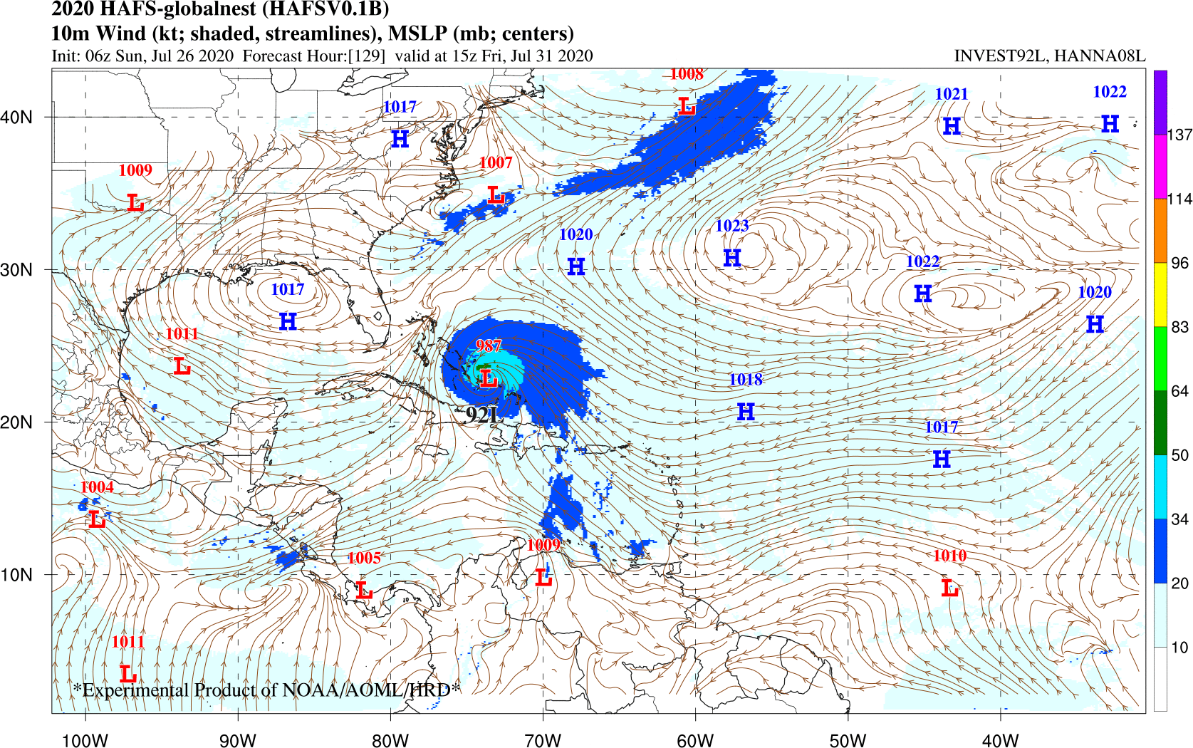
Hurricane Analysis and Forecast System (HAFS) has Invest 92L/Isaias as a hurricane over Bahamas this Saturday. Subject to change.
Hurricane Analysis and Forecast System (HAFS)
https://www.weather.gov/media/sti/nggps ... ragada.pdf
Hurricane Analysis and Forecast System (HAFS) has Invest 92L/Isaias as a hurricane over Bahamas this Saturday. Subject to change.
Hurricane Analysis and Forecast System (HAFS)
https://www.weather.gov/media/sti/nggps ... ragada.pdf
-
Ptarmigan
- Statistical Specialist
- Posts: 4526
- Joined: Wed Feb 03, 2010 7:20 pm
- Contact:
GFS Ensemble for Invest 92L.

Looks to be an East Coast hurricane at this time. Always subject to change.
Looks to be an East Coast hurricane at this time. Always subject to change.
-
srainhoutx

- Site Admin

- Posts: 19700
- Joined: Tue Feb 02, 2010 2:32 pm
- Location: Maggie Valley, NC
- Contact:
92L will likely we a slow developer and probably will not slow down it's rapid Westerly motion until mid/late this week as it begins its approach to the Eastern Caribbean. Careful with the various computer schemes including the ensembles beyond 3 to 5 days. I suspect they will not an idea what might happen until reconnaissance missions from the AF and possibly a G-IV high altitude mission give additional data to those model solutions.
Carla/Alicia/Jerry(In The Eye)/Michelle/Charley/Ivan/Dennis/Katrina/Rita/Wilma/Humberto/Ike/Harvey
Member: National Weather Association
Facebook.com/Weather Infinity
Twitter @WeatherInfinity
Member: National Weather Association
Facebook.com/Weather Infinity
Twitter @WeatherInfinity
-
Cpv17
- Posts: 7094
- Joined: Fri Aug 31, 2018 1:58 pm
- Location: El Campo/Wharton
- Contact:
Models tend to recurve systems out to sea at first and then adjust back west with time. Don’t let your guard down with 92L because it’s way too early for models to know where it’ll go. Ridges and troughs constantly change, especially past 3 days.
-
Texaspirate11

- Posts: 1278
- Joined: Tue Dec 31, 2013 12:24 am
- Contact:
I'm liking the gfs and I never like the gfs
I'm really hoping for a recurve and ots
I'm really hoping for a recurve and ots
Just because you're disabled, you don't have to be a victim
Be Weather Aware & Prepared!
Barbara Jordan Winner in Media
Disability Integration Consultant
Be Weather Aware & Prepared!
Barbara Jordan Winner in Media
Disability Integration Consultant
-
Ptarmigan
- Statistical Specialist
- Posts: 4526
- Joined: Wed Feb 03, 2010 7:20 pm
- Contact:
I am not letting my guards down yet.
-
Cpv17
- Posts: 7094
- Joined: Fri Aug 31, 2018 1:58 pm
- Location: El Campo/Wharton
- Contact:
The latest Euro takes this as far west as the central Gulf before turning north. Models shifting further south and west it seems.
-
Stormlover2020
- Posts: 565
- Joined: Mon Jun 01, 2020 6:04 pm
- Contact:
Let’s see how strong that trough is
-
unome
- Posts: 3062
- Joined: Fri Feb 12, 2010 6:11 pm
quite the storn - no chance of getting back to sleep now though, might as well put the coffee on !
https://map.blitzortung.org/#7.14/29.712/-95.461
https://www.harriscountyfws.org/

https://map.blitzortung.org/#7.14/29.712/-95.461
https://www.harriscountyfws.org/
-
Cpv17
- Posts: 7094
- Joined: Fri Aug 31, 2018 1:58 pm
- Location: El Campo/Wharton
- Contact:
The HRRR is having fits trying to figure this setup out.
-
Cromagnum
- Posts: 3065
- Joined: Thu Feb 03, 2011 10:42 pm
- Location: Georgetown
- Contact:
Raining like crazy south of town since about 5 AM. Glad I mowed.
-
Cpv17
- Posts: 7094
- Joined: Fri Aug 31, 2018 1:58 pm
- Location: El Campo/Wharton
- Contact:
Got another .60 this morning. I’ll take it!
-
unome
- Posts: 3062
- Joined: Fri Feb 12, 2010 6:11 pm
August Precip Climo - it looks like there is a dry donut hole right over Jason's neighborhood - validation
large image: https://pbs.twimg.com/media/EeWiNa0U4AA ... =4096x4096
https://twitter.com/Climatologist49/sta ... 28/photo/1
large image: https://pbs.twimg.com/media/EeWiNa0U4AA ... =4096x4096
https://twitter.com/Climatologist49/sta ... 28/photo/1
-
jasons2k

- Posts: 6196
- Joined: Thu Feb 04, 2010 12:54 pm
- Location: Imperial Oaks
- Contact:
Hehe! Yep a big red/brown dot right on me.unome wrote: ↑Sun Aug 02, 2020 3:20 am August Precip Climo - it looks like there is a dry donut hole right over Jason's neighborhood - validation
large image: https://pbs.twimg.com/media/EeWiNa0U4AA ... =4096x4096
https://twitter.com/Climatologist49/sta ... 28/photo/1
Total opposite of the Tampa Bay area.
-
jasons2k
- Posts: 6196
- Joined: Thu Feb 04, 2010 12:54 pm
- Location: Imperial Oaks
- Contact:
There are some storms up to the northwest drifting down towards the area.
-
DoctorMu

- Posts: 8047
- Joined: Sun Jun 28, 2015 11:58 am
- Location: College Station
- Contact:
Yeah, we've been getting that northerly flow for about 24 hours. Breezy and some cells drifting down toward B/CS. The last few days are the kind of Texas summer I can live with.
Enjoying this while it lasts (which won't be long)!
-
DoctorMu
- Posts: 8047
- Joined: Sun Jun 28, 2015 11:58 am
- Location: College Station
- Contact:

-
Cpv17
- Posts: 7094
- Joined: Fri Aug 31, 2018 1:58 pm
- Location: El Campo/Wharton
- Contact:
It’s still really hot down here in Wharton today. It’s very steamy here because of all the rain we’ve had. Quite uncomfortable out there.
-
DoctorMu
- Posts: 8047
- Joined: Sun Jun 28, 2015 11:58 am
- Location: College Station
- Contact:
Major donut hole effect with this cluster. Northern skies with dark blue green a moment ago. Seas attempting to part...
It's 2 AM at the August climo bar, and we need to belly up one last time!
It's 2 AM at the August climo bar, and we need to belly up one last time!